WebQuest: What is CWPPRA and How Are Regions Monitored? Exploring CRMS!
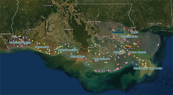
Click the image above to explore an interactive map of CWPPRA’s protection and restoration projects across coastal Louisiana. Is there a project near your home or one of your favorite places to visit?
Introduction
The coastal regions of Louisiana are in a constant state of change. From hurricanes to sea level rise, the marsh lands are in critical condition. Additionally, human impacts have increased the rate at which the coastal regions are changing. The Coastal Wetlands Planning, Protection and Restoration Act, (CWPPRA pronounced kwǐp-rŭh), is federal legislation enacted in 1990 that is designed to identify, prepare, and fund construction of coastal wetlands restoration projects. Since its inception, 229 coastal restoration or protection projects have been authorized, benefiting approximately 100,600 acres in Louisiana. Use the following resources to learn more about CWPPRA and how CRMS provides data for coastal restoration efforts.
CRMS: Understanding why monitoring is so important.
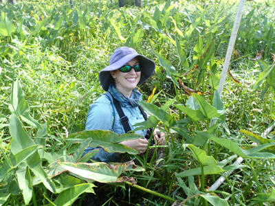
Pictured above is Rachel Villani collecting data for CRMS. Click on the image to learn about monitoring coastal wetlands through CRMS in a podcast sponsored by USGS.
When teams of biologists, engineers, environmental scientists, and concerned citizens work together to protect the environment, positive changes can be made. In order to understand what needs to be done and to develop solutions, we must first understand what is happening in coastal regions. The data from monitoring coastal wetlands is used to understand what is happening throughout Louisiana’s coastal zone. Check out the August 2018 Watermarks publication to understand how CWPPRA gets data about coastal wetlands.
Resource: https://lacoast.gov/new/Data/WaterMarks/Watermarks58.pdf
MS-LS2-5, MS-ESS2-2, MS-ESS3-2, MS-ESS3-3
- What does the acronym CRMS stand for?
- What are the four types of data CRMS collects?
- How can these sets of information be helpful for planning CWPPRA projects:
- Use the images on page 4 and 5 to explore the following monitoring systems.
- An H01 hydrographic stations
- a soil pore water station
- a surface elevation change station
- a vertical accretion station
- Choose one of the stations listed above to study in detail. Research the following information in the Watermarks publication as well as other trusted resources.
- What type of data is being collected?
- What tool is used to measure the data?
- How does the information help with CWPPRA’s goals?
- Once you have completed the research and you understand how the information is gathered, make a functional model of the monitoring station.
You can use common household materials such as: tissue boxes, pipe cleaners, cardstock, construction paper, string, and empty paper towel rolls. Using building blocks (such as Legos) may also help.
- Your model should demonstrate how the machinery works and how the data is read.
- Discuss your research and model with your classmates.
- Two of the critical data points collected at coastwide monitoring system sites include salinity and temperature. If possible, use a refractometer to measure salinity of a local body of water. Also, your teacher can show you how to use a water thermometer.
It is best to monitor a body of water over time. You may see seasonal shifts so averaging the data can show annual changes. If your class is able to collect salinity and temperature data of a water sample, create and maintain a chart for each data collection. You may want to use one such as the following:
|
Date of Colletction
|
Temperature (°C)
|
Salinity (ppt)
|
|
|
|
|
|
|
|
|
|
|
|
|
|
|
|
|
|
|
|
|
|
|
|
|
|
|
|
|
- The data that these monitoring stations collect is published on the CRMS website. Access the website to explore the conditions: https://lacoast.gov/crms/Home.aspx#
Click on the link of maps. This link shows you the widespread monitoring occuring along the coastal wetlands.
Zoom into an area, and click on a monitoring site.
- Record the latitude and longitude of the site you selected. You can find this information under the info tab.
- Using the tabs at the top, determine:
- What has CRMS done in that location? You can use the pre and post construction pictures to help you.
- What is the most recent water salinity (mean) reading?
- How has it changed over the last year?
- What is the most recent water temperature (mean) reading?
- How has it changed over the span of time that the site has been collecting data?
- Record at least three other pieces of important data.
Spend some time exploring other data on the CRMS website. It is a fascinating and informative site. Share your findings with classmates.
Watch the following CWPPRA video: Be sure to pause the video as you research the following questions.
- How much area of wetlands is lost every hour?
- Mr. Kinler talks about wetland loss being a natural phenomenon and a human-induced problem.
- Describe the natural changes that are causing wetland loss.
- What have humans done that have negatively impacted wetlands?
- What do CWPPRA projects do?
- Why do numerous project types have to occur in order to best preserve wetlands?
- How does CWPPRA benefit from a wide range of expert input?
- Why do wetlands need protecting?
- Coastal Louisiana wetland loss was called an ecological disaster. Explain this term.
In conclusion, you began this research to understand more about CWPPRA, it’s mission, and the on-going restoration projects. Now that you’ve explored data, the goals, and tools used for wetland restoration, consider the following scenario.
You and your friends are walking on a Louisiana beach. While observing the beautiful scenery and listening to the waves, you notice orange construction banners. As you walk closer to the construction zones, you notice that a sign is posted. The sign states that the beach is a CWPPRA restoration project. There are boulders and rocks that are being neatly placed as a buffer zone away from the beach. Your friend asks you what CWPPRA is and what is going on. How would you answer this question?
Create a graphic novel style cartoon that illustrates the scenario. Within the graphics, be sure to include descriptions of what the characters are thinking or saying. Your answer to the question about CWPPRA should be clearly recognizable. A template for your drawings is below. However, if allowed, you can also choose to make a cartoon online.
Graphic Novel Template: