
Much of the basin is occupied by three large
bays: East Cote Blanche Bay, West Cote Blanche Bay, and Vermilion Bay. Marsh
Island is an important hydrologic feature because it separates these bays from
saltier water in the Gulf of Mexico. Therefore, marshes in this basin are
primarily fresh, intermediate, and brackish with relatively few salt marshes.
The Vermilion Basin lost 42,293 acres (14.8 percent) of marsh since 1932,
nearly half of which was lost between 1951 and 1974, which is a relatively low
rate compared to rates in other basins. Marsh loss is relatively slow because
the basin is in the later stages of the delta lobe cycle; the more delicate
wetlands deteriorated centuries ago. In fact, the delta lobe cycle has proceeded
to the point that the basin should be experiencing rapid wetland creation in
association with the emerging Atchafalaya River delta, but wetlands are not
being built at maximum rates because the flow of fresh water and sediments down
the Atchafalaya River is controlled at the Old River Control Structure. Fresh
water and sediments from the Atchafalaya River benefit the basin nonetheless.
Furthermore, numerous live and relic oyster reefs southeast of Marsh Island
buffer water exchange between the big bays and the Gulf of Mexico, which also
contributes stability.
Although the basin is geologically stable and benefits from the emerging
Atchafalaya River delta, geomorphologic and hydrologic conditions have been
altered by the dredging of navigation and petroleum access canals and the
construction of spoil banks and levees. The effects of these alterations vary
greatly from place to place, but generally they have created artificial barriers
between wetlands and wetland maintenance processes, or removed natural barriers
between wetlands and wetland decay processes. Interior marshes, traditionally
maintained by annual flooding with fresh water in the spring, may deteriorate
when exposed to increasing marine conditions, particularly in marshes where the
soils have low mineral content. However, marshes near the Gulf of Mexico benefit
from linkage with the gulf because winter storms deliver sediments to those
marshes. Many landowners have responded to changing conditions caused by
large-scale alterations by managing hydrologic conditions on a small scale using
marsh management techniques. It is possible that some of these management
efforts may not preserve marsh, particularly older ones. However, marsh
management is an actively evolving field.
Some wetland loss might also be related to herbivory. Moderate herbivory alone
is not believed to cause wetland loss, but it may be the "final straw"
in marshes experiencing additional stresses such as flooding or saltwater intrusion.
Most wetland loss in the basin occurs either as shoreline erosion or in
isolated hot spots. Areas are classified as hot spots when they experience rapid
loss relative to other marshes within this basin. Hot spots in this basin are
smaller than in other basins; they presumably originate from hydrologic changes
that alter the balance between the marsh maintenance and deterioration
processes, but the specific causes vary from place to place. Canals and spoil
banks have impounded some areas and increased tidal energy in other areas. Thus,
some areas have become isolated from sediment input, whereas water exchange
removes more sediments than are introduced in other areas. Inadvertent
impoundment also causes some areas to flood excessively.
Shoreline erosion on the large bays is caused primarily by natural wave
energy. Wave energy has gradually increased over the centuries because the bays
are naturally getting deeper due to the very slight but constant subsidence and
global sea-level rise. Wave energy is also believed to have been increased
because humans reduced the size of the oyster reefs between Marsh Island and
Point Au Fer that shielded the large bays from wave and tidal energy in the Gulf
of Mexico. Severe shoreline erosion occurs on Marone and Redfish Points, Shark
Island, and the shore of Weeks Bay.
Shoreline erosion can dramatically affect wetland loss when it causes
relatively isolated marsh drainage systems to become hydraulically connected
with dynamic water bodies such as navigation canals and the large bays. In other
areas, shoreline erosion is particularly rapid and causes the direct loss of
significant wetland acreage. These may be classified as hot spots of erosion.
Erosion caused by boat wakes and water surges associated with the passage of
large vessels also causes wetland loss along the GIWW and other navigation
canals.
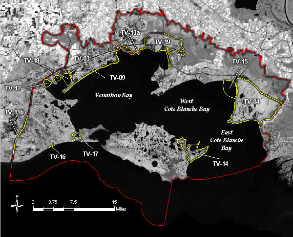
Projects in the Teche / Vermilion Basin
Summary of the Basin Plan
STUDY AREA
The Teche/Vermilion Basin contains roughly 243,000 acres of wetlands in
Vermilion, Iberia, and St. Mary parishes. The basin extends westward from Point
Chevreuil through East and West Cote Blanche Bays, and includes Marsh Island and
Vermilion Bay. The basin is bordered on the east by the West Atchafalaya Basin
Protection Levee, on the west by Freshwater Bayou Canal and Louisiana Highway
82, on the north by the Lafayette/Vermilion and St. Martin/Iberia parish lines,
and on the south by the Gulf of Mexico (Figure TV-1).
EXISTING CONDITIONS AND PROBLEMS
Much of the basin is occupied by three large bays: East Cote Blanche Bay,
West Cote Blanche Bay, and Vermilion Bay. Marsh Island is an important
hydrologic feature because it separates these bays from saltier water in the
Gulf of Mexico. Therefore, marshes in this basin are primarily fresh,
intermediate, and brackish with relatively few salt marshes. The Teche/Vermilion
Basin lost 42,293 acres (14.8 percent) of marsh since 1932, nearly half of
which was lost between 1951 and 1974, which is a relatively low rate compared to
rates in other basins. Marsh loss is relatively slow because the basin is in the
later stages of the delta lobe cycle; the more delicate wetlands deteriorated
centuries ago. In fact, the delta lobe cycle has proceeded to the point that the
basin should be experiencing rapid wetland creation in association with the
emerging Atchafalaya River delta, but wetlands are not being built at maximum
rates because the flow of fresh water and sediments down the Atchafalaya River
is controlled at the Old River Control Structure. Fresh water and sediments from
the Atchafalaya River benefit the basin nonetheless. Furthermore, numerous live
and relic oyster reefs southeast of Marsh Island buffer water exchange between
the big bays and the Gulf of Mexico, which also contributes stability.
Although the basin is geologically stable and benefits from the emerging
Atchafalaya River delta, geomorphologic and hydrologic conditions have been
altered by the dredging of navigation and petroleum access canals and the
construction of spoil banks and levees. The effects of these alterations vary
greatly from place to place, but generally they have created artificial barriers
between wetlands and wetland maintenance processes, or removed natural barriers
between wetlands and wetland decay processes. Interior marshes, traditionally
maintained by annual flooding with fresh water in the spring, may deteriorate
when exposed to increasing marine conditions, particularly in marshes where the
soils have low mineral content. However, marshes near the Gulf of Mexico benefit
from linkage with the gulf because winter storms deliver sediments to those
marshes. Many landowners have responded to changing conditions caused by
large-scale alterations by managing hydrologic conditions on a small scale using
marsh management techniques. It is possible that some of these management
efforts may not preserve marsh, particularly older ones. However, marsh
management is an actively evolving field.
Some wetland loss might also be related to herbivory. Moderate herbivory
alone is not believed to cause wetland loss, but it may be the final straw in
marshes experiencing additional stresses such as flooding or saltwater
intrusion.
Most wetland loss in the basin occurs either as shoreline erosion or in
isolated hot spots. Areas are classified as hot spots when they experience rapid
loss relative to other marshes within this basin. Hot spots in this basin are
smaller than in other basins; they presumably originate from hydrologic changes
that alter the balance between the marsh maintenance and deterioration
processes, but the specific causes vary from place to place. Canals and spoil
banks have impounded some areas and increased tidal energy in other areas. Thus,
some areas have become isolated from sediment input, whereas water exchange
removes more sediments than are introduced in other areas. Inadvertent
impoundment also causes some areas to flood excessively.
Shoreline erosion on the large bays is caused primarily by natural wave
energy. Wave energy has gradually increased over the centuries because the bays
are naturally getting deeper due to the very slight but constant subsidence and
global sea-level rise. Wave energy is also believed to have been increased
because humans reduced the size of the oyster reefs between Marsh Island and
Point Au Fer that shielded the large bays from wave and tidal energy in the Gulf
of Mexico. Severe shoreline erosion occurs on Marone and Redfish Points, Shark
Island, and the shore of Weeks Bay.
Shoreline erosion can dramatically affect wetland loss when it causes
relatively isolated marsh drainage systems to become hydraulically connected
with dynamic water bodies such as navigation canals and the large bays. In other
areas, shoreline erosion is particularly rapid and causes the direct loss of
significant wetland acreage. These may be classified as hot spots of erosion.
Erosion caused by boat wakes and water surges associated with the passage of
large vessels also causes wetland loss along the GIWW and other navigation
canals.
FUTURE WITHOUT-PROJECT CONDITIONS
Over the next 20 years, 14,700 acres or 6.1 percent of the marsh (based on
1988 marsh acres) will be lost unless preventative measures are taken (Table
TV-1). Within the next 50 years, 36,750 acres or 15.1 percent percent of the
marsh will be lost. Cumulative losses since 1932 will approach 28 percent by
2040. In 50 years, shoreline erosion will reduce Marone Point, Redfish Point,
and Shark Island, and Weeks Bay will be larger. The interior marshes on Marone
Point, those north and south of the GIWW between the Vermilion River Cutoff and
Tigre Lagoon, the south central marshes on Marsh Island, and marshes on State
and Rainey refuges will become shallow ponds. This will reduce fisheries
available for harvest by commercial and recreational fishermen and wintering
habitat for millions of waterfowl. The growing ecotourism industry will be
negatively affected, and storm surge protection will be reduced.
Table TV-1
Wetland Loss in the Teche/Vermilion Basin.
Measured Loss Projected Loss in 20 years Projected Loss in 50 years
1932-1990 (Acres) (Acres) (Percent) (Acres) (Percent)
42,293 14,700 6.1 36,750 15.1
BASIN PLAN
Several objectives were developed to guide protection, restoration, and
creation of wetlands within the Teche/Vermilion Basin. These objectives were
based on prevailing conditions in the basin. A description of the plan
formulation process is contained in Appendix G.
The short-term portion of the plan is dominated by projects that protect
critical shorelines, restore more natural hydrological conditions, and determine
the causes of marsh loss in hot spots so that site specific counter-measures can
be designed. Locations of major areas of activity are noted in Figure TV-2. The
long-term goal of the plan is to maximize spring flooding of wetlands, which
will require feasibility studies and coordination with adjacent basins.
Shoreline erosion will ultimately slow because the bays are gradually filling
with Atchafalaya River sediments. But this may take centuries without additional
flow from the Mississippi River into the Atchafalaya River. Nonetheless, it may
be possible to accelerate this process in some areas, and high priority is given
to projects that speed this beneficial process, such as sediment trapping in
Little Vermilion Bay.
There are substantial benefits to protecting some current shorelines that
shield relatively isolated marsh ponds and bayous. It is preferred that these
projects use beach nourishment, dredged material, and sediment trapping, but it
may be necessary to use hard structures to protect some fragile but critical
shorelines. Such projects are cost effective because they prevent rapid
hydrological changes from occurring throughout large areas. This is the primary
focus of critical short-term projects in many areas such as Lake Sand at Marsh
Island.
Several critical projects restore more natural hydrological conditions on a
small scale. For example, the Cote Blanche Hydrologic Restoration project slows
shoreline erosion, restores hydrologic barriers between interior marshes and the
bays, and controls water exchange between the GIWW and the project area, but
does not include complete enclosure by levees. The net result is that this marsh
is protected from artificial water exchange and shoreline erosion, but can still
flood with fresh, sediment-rich water from the Atchafalaya River that is
available in the adjacent GIWW and bays each spring.
Reducing loss in hot spots requires various measures such as sediment
trapping, hydrologic restoration, and freshwater diversion. Addressing hot spots
requires site-specific techniques in different areas because causes of wetland
loss and the availability of counter measures vary throughout the basin.
Restoring spring flooding with fresh, sediment-rich waters may someday stop
marsh loss in hot spots, but it is important to protect these areas from loss
now because if they convert to ponds, they will have to be restored--a much more
expensive process.
Thus, these projects are also classified as critical short-term even though
specific causes of wetland loss must first be determined in each hot spot. Once
site specific causes of marsh loss have been determined, then appropriate
techniques, e.g., sediment trapping, hydrologic restoration, and freshwater
diversions, can be implemented.
Restoring spring flooding to interior marshes provides optimum salinity
levels and introduces mineral sediments, which promote plant growth. Restoring
spring flooding on a regional scale is an important long-term goal, but it
requires increased sediment delivery to the Wax Lake Delta; managing diversions
into the Vermilion
River, Bayou Teche, and the GIWW during the spring flood; or increasing
discharge of the Atchafalaya River. Increasing fresh water and sediments
available from the Atchafalaya will also speed bay filling, which will slow
shoreline erosion and initiate wetland creation in Vermilion Bay, West Cote
Blanche Bay, and East Cote Blanche Bay. Detailed study and planning are
necessary to determine if these concepts are feasible. Thus, no projects are
proposed at this time even though restoring spring flooding on a regional scale
is a critical long-term strategy.
Projects in the Teche/Vermilion Plan are listed in Table TV-2, which displays
the project type and classification. A detailed description of all projects
proposed in the Teche/Vermilion Basin can be found in Appendix G, Table 9.
COSTS AND BENEFITS
The short-term projects proposed in the selected plan will protect or create
4,770 acres of marsh and prevent 30 percent of the predicted loss at a cost of
$34,039,000 (Table TV-3). In addition, 5,010 acres of marsh and submerged
aquatic vegetation will be enhanced. Costs and benefits of the other three
short-term critical projects cannot be determined until the site-specific causes
of marsh loss can be determined in each hot spot.
Table TV-3
Costs and Benefits of the Selected Plan
Acres Created, Percent Total
Project Protected, or Loss Benefited Cost
Classification Restored Prevented Acres ($)
Critical Short-Term 3,840 26 8,720 22,149,000
Supporting Short-Term 930 4 1,060 11,890,000
Total 4,770 30 9,780 34,039,000
Less than half of the marsh loss predicted to occur in this basin can be
countered with the projects listed in the plan. Additional efforts will
therefore be needed to achieve no net loss of wetlands. Substantial gains may be
possible by addressing marsh loss in the hot spots. However, the most beneficial
action is likely to be maximizing spring flooding on a regional scale. In
addition to slowing marsh loss processes of saltwater intrusion and sediment
starvation, this would likely promote creation of new wetlands. This is one of
the few basins with substantial potential for wetlands creation, and every
avenue to maximize spring flooding should be explored.
Back to Top
Dynamics of the Basin
The Teche/Vermilion Basin contains approximately 243,000 acres of wetlands in
Vermilion, Iberia, and St. Mary parishes (figure 23). The basin extends westward
from Point Chevreuil through East and West Cote Blanche bays, and includes Marsh
Island and Vermilion Bay. The basin is bordered on the east by the West
Atchafalaya Basin Protection Levee, on the west by Freshwater Bayou Canal, on
the north by the Lafayette/Vermilion and St. Martin/Iberia parish lines, and on
the south by the Gulf of Mexico. Portions of the marshes are privately owned,
and over 50% of the marshes are managed as wildlife refuges by the state of
Louisiana and the Audubon Society. Collectively, the Louisiana State Wildlife
Refuge, Marsh Island Wildlife Refuge, and the National Audubon Society's Paul J.
Rainey Wildlife Refuge encompass over 139,000 acres of marsh and associated
bayous, ponds, and lakes. The basin is composed of 5% cypress/tupelo swamp, 14%
fresh marsh, 11% intermediate marsh, 36% brackish marsh, and 3% salt marsh
(LCWCRTF 1993). The marsh soils are classified as highly organic peats, which
are continually forming on the marsh surface through plant production and, more
importantly, below ground through root growth (Nyman et al. 1992).
The principal hydrologic features of the basin include the Vermilion River,
Charenton Canal, the Gulf Intracoastal Waterway (GIWW), the natural levee ridges
of the Vermilion River and Bayou Teche, East and West Cote Blanche bays, and
Vermilion Bay. Unlike other basins in the chenier plain, the Teche/Vermilion
Basin has direct riverine inputs. This basin is experiencing an increase in
riverine conditions because of sediment-laden freshwater flow from the
Atchafalaya River (DeLaune et al. 1987). Water and sediment from the Atchafalaya
River enter the basin from the east, flow westward, and dominate hydrological
conditions in East and West Cote Blanche bays, which are gradually filling with
sediment.
Wetlands in the Teche/Vermilion Basin are stable relative to many other
Louisiana coastal marshes, with only 50,540 acres of land loss (9% of land area)
since 1932 (Dunbar et al. 1992). The current basin land loss is approximately
650 (Barras et al. 1994) to 900 (Dunbar et al. 1992) acres per year and accounts
for less than 3% of Louisiana's total coastal land loss. This lower relative
loss rate is attributable to the older, and therefore more compacted, soils of
the chenier plain. Wetland loss in the basin tends to be localized and occurs
primarily as either shoreline erosion or in isolated hot spots of interior marsh
deterioration (figure 23). Alterations resulting in hot spots of loss include
the construction of navigation channels, oil and gas access canals, spoil banks,
and levees. Some of the basin's wetland loss may also be related to heavy
grazing by nutria and possibly muskrat. At current land loss rates, the
Teche/Vermilion Basin will lose between 12,840 and 17,860 acres of land during
the next 20 without restorative action.
Marsh loss in the Teche/Vermilion Basin also occurs as a result of shoreline
erosion along large bodies of water and navigation canals. Shoreline erosion on
the large bays is mainly caused by natural wave energy. In contrast, erosion
along the GIWW and other navigation channels is caused by boat wakes and water
surges associated with the passage of large vessels. Some shorelines form
natural barriers between dynamic water bodies, such as bays and navigation
channels, and the relatively isolated marsh ponds and bayous of the marsh
interior. When these shorelines erode, the high energies associated with the
dynamic water bodies begin to erode the fragile interior marsh (figure 24).
Although the bays are relatively sediment rich, spoil banks, levees, and
access canals have isolated some areas from sediment input, which can result in
a net loss of sediment. Areas that become impounded are subject to excessive
flooding, while areas that have existing hydrologic barriers removed may be
subject to saltwater intrusion.
Back to Top
Discussion
In order to successfully protect, restore, and enhance the marshes within the
Teche/Vermilion Basin, it is critical that projects be implemented to optimize
use of freshwater and sediment inflows, address marsh loss hot spots, and
preserve shorelines that serve as barriers between dynamic water bodies and
interior marshes. Efforts to maximize flooding input from the Atchafalaya River
are critical since, unlike other basins in the chenier plain, the
Teche/Vermilion Basin has significant potential for fluvial inputs. The CWPPRA
projects that have been or will be implemented address these objectives.
Although it is too early to determine the success of the CWPPRA projects,
preliminary indications are that the project goals are being met.