
The three large lakes, Maurepas,
Pontchartrain, and Borgne cover 55 percent of the basin. Lakes Maurepas and
Pontchartrain are separated by land bridges of cypress swamp and
fresh/intermediate marsh. A brackish marsh land bridge separates Lake
Pontchartrain from Lake Borgne.
The basin contains 483,390 acres of wetlands, consisting of nearly 38,500
acres of fresh marsh, 28,600 acres of intermediate marsh, 116,800 acres of
brackish marsh, 83,900 acres of saline marsh, and 215,600 acres of cypress
swamp. Since 1932, more than 66,000 acres of marsh have converted to water in
the Pontchartrain Basin--over 22 percent of the marsh that existed in 1932. The
primary causes of wetland loss in the basin are the interrelated effects of
human activities and the estuarine processes that began to predominate many
hundreds of years ago, as the delta was abandoned.
The Mississippi River levees significantly limit the input of fresh water,
sediment, and nutrients into the basin. This reduction in riverine input plays a
part in the major critical problem in the Pontchartrain Basin--increased
salinity. Construction of the MRGO, which breaches the natural barrier of the
Bayou La Loutre ridge and the Borgne land bridge, allowed saline waters to push
farther into the basin. Relative sea level rise of up to 0.96 feet per century
gives saltier waters greater access to basin wetlands. Mean monthly salinities
have increased since the construction of the MRGO and other canals. However,
these mean increases are less than the overall variability in salinity. In
recent years, salinities have stabilized. The heightened salinity, caused mainly
by subsidence, stresses wetlands, especially fresh marsh and swamp.
A second critical problem, occurring in the lower basin, is the erosion along
the MRGO caused by ship-induced waves. The channel's north bank continues to
eroding at a rate of 15 feet per year. This mechanism has resulted in the direct
loss of over 1,700 acres of marsh since 1968.
The third critical problem is the potential loss of the Borgne and the
Maurepas land bridges where wetland soils are especially vulnerable to erosion.
Since 1932, approximately 24 percent of the Borgne Land Bridge has been lost to
estuarine processes such as severe shoreline retreat and rapid tidal
fluctuations, and the loss rate is increasing. During the same time, 17 percent
of the Maurepas Land Bridge marshes disappeared due to subsidence and spikes in
lake salinity. In addition, from 1968 to 1988, 32 percent of the cypress swamp
on this land bridge either converted to marsh or became open water. These land
bridges prevent estuarine processes, such as increased salinities and tidal
scour, from pushing further into the middle and upper basins. If these buffers
are not preserved, the land loss rates around Lakes Pontchartrain and Maurepas
will increase dramatically.
The fourth critical problem is that several marshes in the basin are
vulnerable to rapid loss if adequate protection is not provided soon. Examples
of theses areas are: marshes adjacent to lakes and bays where if the narrow rim
of shore is lost, interior erosion will increase dramatically; the perched fresh
marsh on the MRGO disposal area which will drain and revegetate with shrub
unless the back levee dikes are repaired; and near Bayou St. Malo, where unless
canals are plugged, rapid water level fluctuations and salinity intrusion into
adjacent marshes will continue.
Site specific problems of shoreline erosion, poor drainage, salinity stress,
and herbivory are apparent throughout the basin. Solving these problems is
important, but less urgent than solving the four critical problems described
above.
Projects in the Potchartrain Basin
Summary of the Basin Plan
STUDY AREA
The 1,700,000-acre Pontchartrain Basin is an abandoned delta generally
bounded by the Pleistocene Terrace on the north and west, by Chandeleur Sound on
the east, and by the Mississippi River and the disposal area of the Mississippi
River Gulf Outlet (MRGO) on the south. Portions of nine parishes lie within the
basin: Ascension, St. James, St. John the Baptist, St. Charles, Jefferson,
Orleans, St. Bernard, St. Tammany, and Livingston. The basin is divided into six
distinct areas: the upper, middle, lower, and Pearl basins, and the Lake
Maurepas/Pontchartrain and Lake Pontchartrain/Borgne land bridges (Figure PO-1).
Approximately 17 percent of the land in the basin is in public ownership.
EXISTING CONDITIONS AND PROBLEMS
The three large lakes, Maurepas, Pontchartrain, and Borgne cover 55 percent
of the basin. Lakes Maurepas and Pontchartrain are separated by land bridges of
cypress swamp and fresh/intermediate marsh. A brackish marsh land bridge
separates Lake Pontchartrain from Lake Borgne.
The basin contains 483,390 acres of wetlands, consisting of nearly 38,500
acres of fresh marsh, 28,600 acres of intermediate marsh, 116,800 acres of
brackish marsh, 83,900 acres of saline marsh, and 215,600 acres of cypress
swamp. Since 1932, more than 66,000 acres of marsh have converted to water in
the Pontchartrain Basin--over 22 percent of the marsh that existed in 1932. The
primary causes of wetland loss in the basin are the interrelated effects of
human activities and the estuarine processes that began to predominate many
hundreds of years ago, as the delta was abandoned.
The Mississippi River levees significantly limit the input of fresh water,
sediment, and nutrients into the basin. This reduction in riverine input plays a
part in the major critical problem in the Pontchartrain Basin--increased
salinity. Construction of the MRGO, which breaches the natural barrier of the
Bayou La Loutre ridge and the Pontchartrain/Borgne land bridge, allowed saline
waters to push farther into the basin. Relative sea level rise of up to 0.96
feet per century gives saltier waters greater access to basin wetlands. Mean
monthly salinities have increased since the construction of the MRGO and other
canals. However, these mean increases are less than the overall variability in
salinity. In recent years, salinities have stabilized. The heightened salinity,
caused mainly by subsidence, stresses wetlands, especially fresh marsh and
swamp.
A second critical problem, occurring in the lower basin, is the erosion along
the MRGO caused by ship-induced waves. The channel's north bank continues to
eroding at a rate of 15 feet per year. This mechanism has resulted in the direct
loss of over 1,700 acres of marsh since 1968.
The third critical problem is the potential loss of the Pontchartrain/Borgne
and the Pontchartrain/Maurepas land bridges where wetland soils are especially
vulnerable to erosion. Since 1932, approximately 24 percent of the
Pontchartrain/Borgne Land Bridge has been lost to estuarine processes such as
severe shoreline retreat and rapid tidal fluctuations, and the loss rate is
increasing. During the same time, 17 percent of the Pontchartrain/Maurepas Land
Bridge marshes disappeared due to subsidence and spikes in lake salinity. In
addition, from 1968 to 1988, 32 percent of the cypress swamp on this land bridge
either converted to marsh or became open water. These land bridges prevent
estuarine processes, such as increased salinities and tidal scour, from pushing
further into the middle and upper basins. If these buffers are not preserved,
the land loss rates around Lakes Pontchartrain and Maurepas will increase
dramatically.
The fourth critical problem is that several marshes in the basin are
vulnerable to rapid loss if adequate protection is not provided soon. Examples
of theses areas are: marshes adjacent to lakes and bays where if the narrow rim
of shore is lost, interior erosion will increase dramatically; the perched fresh
marsh on the MRGO disposal area which will drain and revegetate with shrub
unless the back levee dikes are repaired; and near Bayou St. Malo, where unless
canals are plugged, rapid water level fluctuations and salinity intrusion into
adjacent marshes will continue.
Site specific problems of shoreline erosion, poor drainage, salinity stress,
and herbivory are apparent throughout the basin. Solving these problems is
important, but less urgent than solving the four critical problems described
above.
FUTURE WITHOUT-PROJECT CONDITIONS
If nothing is done, and marsh loss continues at the pace set from 1974-1990,
another 62,400 acres, or 23 percent of the basin's existing marshes, would be
lost by the year 2040, as displayed in Table PO-1. If no action is taken, 69,400
acres of swamp, 32 percent of the basin's existing swamp, would be converted to
marsh or open water by 2040. This does not include the possible loss of the
upper basin swamps. As the land bridges are lost, estuarine processes would push
farther into the basin and erosion rates would increase. The middle basin would
be a lake surrounded by shallow ponds where marshes once existed. The lower
basin marshes would be a tattered remnant of what exists today. Fewer fish and
shellfish would be available for commercial or recreational fishermen. Vast
marshes for wintering ducks would no longer exist. The emerging ecotourism
industry would be hindered, and storm surge protection would be lost as lakes
and bays inched closer to levees and roads.
Table PO-1
Projected Marsh and Swamp Loss
Projected Loss in 20 years Projected loss in 50 years
Subbasin (Acres) (Percent) (Acres) (Percent)
Upper Basin
Swamp 0 0 0 0
Pontchartrain/Maurepas Land Bridge
Swamp 23,200 38 58,000 95
Marsh 1,320 6 3,300 15
Middle Basin
Swamp 9,600 62 11,400 74
Marsh 3,800 12 9,500 30
Pontchartrain/Borgne Land Bridge
Marsh 4,560 10 11,400 30
Lower Basin
Marsh 14,580 9 36,450 24
Pearl River Basin
Marsh 700 4 1,750 10
Total Swamp Loss 32,800 15 69,400 32
Total Marsh Loss 24,960 9 62,400 23
Insert Figure PO-1. Pontchartrain Basin, Basin and Subbasin Boundaries.
Back of Figure PO-1. Pontchartrain Basin, Basin and Subbasin Boundaries.
BASIN PLAN
The main strategies of the basin plan are shown in Figure PO-2. Restoration
of riverine input into the basin via freshwater diversion from the Mississippi
River through the Bonnet Carr Spillway solves the first critical problem,
salinity. This is preferred to the strategy of a navigable gate in the MRGO
because the diversion has the added benefit of restoring fluvial input and is
less costly overall and on a per-acre basis. The project is already authorized
and need not be funded under the CWPPRA. An outfall management plan for the
diversion is critical. Construction of a rock dike on the north bank of the MRGO
and the beneficial use of all the material dredged for the MRGO would stop
erosion, addressing the second critical problem, and create large amounts of
marsh. The diversion at the Bonnet Carr Spillway and bank protection with
marsh creation along the MRGO are critical projects.
Additional short-term projects include the following.
- Preservation of the land bridges through shoreline protection, hydrologic
restoration, and marsh management solves the third critical problem. Various
critical projects reduce future marsh loss rates and prevent estuarine processes
from pushing farther into Lakes Pontchartrain and Maurepas.
- Preservation of the several marshes in the basin which are immediately
vulnerable to loss is crucial to resolving the fourth critical problem. Projects
which protect shorelines in several critical areas, preserve the fresh marshes
on the MRGO disposal area, and retain the brackish marshes in the St. Malo area
all require quick implementation.
- Several site specific areas of loss are scattered throughout the basin.
Small-scale measures to preserve, restore, and enhance these marshes and swamps
are important. These supporting projects should be considered once the more
critical projects are in place.
In the long term, getting more fresh water and nutrients into the basin is
critical. Five small-scale freshwater diversions into swamps and marshes of the
basin are proposed. First, however, a study on the sediment and water budget for
the Mississippi River must be completed.
Going beyond these diversions to achieve no net loss of wetlands in the
long-term depends on cost-effective importation of sediment either by diversions
or by dedicated dredging with dispersal by barging or pipelines. This critical
long-term strategy could significantly reduce wetland loss in the basin, but it
is very costly at this time.
Creation of artificial barrier islands could preserve the outer saline
marshes. Although expensive, it is defined as critical and retained in the
selected plan for possible implementation in the long term. Studies are planned
on methods to reduce the cost of construction and to better evaluate benefits to
interior marshes. If costs can be reduced and benefits increased, priority for
implementing this strategy will increase.
The selected plan uses a combination of measures to achieve basin objectives.
Projects accounting for the majority of the acres preserved or created are
distributed in the following manner: hydrologic restoration (27%), freshwater
diversion/outfall management (28%), shoreline protection (24%), and marsh
creation (18%).
In summary, the short-term portion of the basin plan consists of the
freshwater diversion at the Bonnet Carr Spillway and bank protection and marsh
creation along the MRGO complemented by the preservation of the land bridges,
critical areas, and other wetlands using numerous hydrologic restoration, marsh
creation, and shoreline protection projects. The long-term portion of the plan,
necessary to achieve a no net loss of wetlands, consists of additional
freshwater diversions, sediment import, and the creation of barrier islands.
Projects included in the Pontchartrain Basin Plan are listed in Table PO-2.
The table provides the classification (e.g., critical, supportive,
demonstration), estimated benefits and costs, and status of these projects. A
complete listing of all the projects proposed for the Pontchartrain Basin can be
found in Appendix A, Table 8. More detailed information on each project is also
included in Appendix A.
COSTS AND BENEFITS
An expenditure of $132,738,000 on short-term projects and $72,000,000 on
construction and 20 years of maintenance of the Bonnet Carr Freshwater
Diversion will create or preserve 17,320 acres of marsh and 3,600 acres of swamp
and thus prevent 69 percent of the marsh loss and 7 percent of the swamp loss in
the Pontchartrain Basin (see Table PO-3).
As shown in the table, short-term projects prevent 83 to 92 percent of the
future marsh loss on the land bridges and achieve no net loss of marsh in the
middle basin. However the plan prevents only 44 percent of the marsh loss in the
lower basin. Clearly, additional long-term efforts are needed to preserve these
eroding marshes. Construction of the artificial barrier islands prevents the
loss of an additional 33 percent of the lower basin. However, the cost of
barrier island creation, using present technology, is an additional $600
million. Long-term sediment import projects are essential in achieving no net
loss in the lower basin. Sediment import into the upper basin is necessary to
begin to preserve its cypress swamps. The cost of these sediment import projects
is unknown. Thus, complete restoration of the upper and lower basins requires
investigation of cost effective techniques to build barrier islands and import
sediment.
Back to Top
Dynamics of the Basin
The Pontchartrain Basin contains approximately 1.7 million acres and is
bounded by the Pleistocene Terraces on the north and west, by Chandeleur Sound
on the east, and by the Mississippi River and the disposal area of the
Mississippi River Gulf Outlet (MRGO) on the south (figure 17). The marshes are
primarily privately owned (625,000 acres); however, some extensive areas are
managed as a federal wildlife refuge (25,400 acres) or as state wildlife
management areas (100,000 acres). The basin is part of the abandoned St. Bernard
delta and has approximately 935,000 acres (56%) of open water within its
boundary. The remaining 44% of the Pontchartrain Basin is composed of 13%
cypress/tupelo swamp, 2% fresh marsh, 2% intermediate marsh, 7% brackish marsh,
5% saline marsh, and 15% other land.
The major hydrologic features of the basin are Lakes Maurepas, Pontchartrain,
and Borgne, and Chandeleur Sound. Lake Pontchartrain is connected to Lake
Maurepas to the west and Lake Borgne to the east by passes through interlying
land bridges (i.e., a land area separating two hydrologic features). The Inner
Harbor Navigation Canal (IHNC) and the MRGO provide a direct link between Lake
Pontchartrain and the Gulf of Mexico. Historically, fresh water entered the
Pontchartrain Basin through Bayou Manchac (until its closure in 1812) and from
natural crevasses from the Mississippi River (until construction of the Mississippi River
levees in the 1930s). Fresh water now enters the basin through leaks in the
Bonnet Carr Spillway, through the IHNC Lock, the Violet Siphon, numerous small
rivers and bayous (totaling approximately 9,500 cfs), and from direct rainfall.
Urban storm water discharges from the New Orleans metropolitan area also enter
Lake Pontchartrain.
Since 1932, over 76,000 acres of marsh (almost 8% of the basin's land area)
have converted to open water in the Pontchartrain Basin (Dunbar et al. 1992,
figure 17). Based on current loss rates, approximately 1,250 acres of marsh will
continue to be lost each year without restorative action (Dunbar et al. 1992,
Barras et al. 1994) . This loss amounts to approximately 25,000 acres during the
next 20 years. If no action is taken to restore and protect the remaining
wetlands, it is projected that an additional 23% will be lost by the year 2040
(LCWCRTF 1993).
Back to Top
Discussion
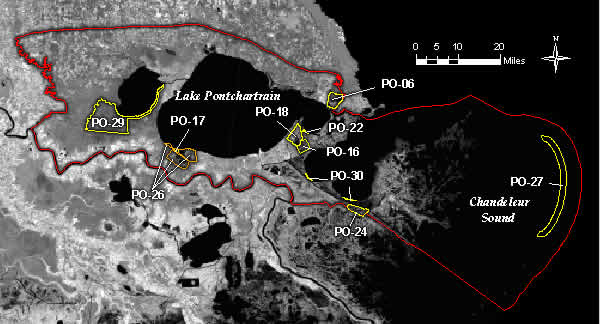
All of the approved CWPPRA projects in the Pontchartrain Basin contribute to the restoration objectives
previously listed. One project, the Violet Freshwater Distribution Project, manages fresh water to
reduce salinity and preserve marsh and swamp. The MRGO Back Dike Marsh Protection project will preserve
marsh within an existing spoil disposal area. Two projects, Bayou Sauvage Phases I and II, improve
hydrology and manage marshes on the land bridges between Lake Pontchartrain and Lakes Maurepas
(on the west) and Borgne (on the east). The Fritchie Marsh project restores wetlands where loss is
imminent. The Bayou Chevee and Bayou La Branche projects beneficially use dredged material to create
marsh. Preliminary results from the Bayou La Branche wetland creation project indicates that this project
is already successful at creating new wetlands in the Pontchartrain Basin (Carriere 1996a). The Eden
Isle project will restore former marsh and regulate water levels to prevent excessive inundation from
Lake Pontchartrain, while the Red Mud Demonstration project will examine some of the issues and concerns
regarding the use of this waste material for marsh creation on a small scale.