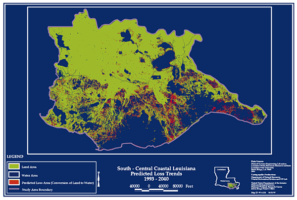
Figure 10. South central coastal Louisiana predicted loss trend from 1993-2040 (adapted from T. Baker Smith & Son, 1996)
Wetland Loss In Louisiana
History of Wetland Loss
Over the last 200 years, wetlands in the United States have been drained, dredged, filled, leveled and flooded for urban, agricultural, and residential development (Mitsch and Gosselink 1993). Because of these activities, 22 states have lost 50% or more of their original wetlands. The problem in Louisiana is somewhat different–wetland growth and deterioration have been naturally occurring here for thousands of years.
Over the past 10,000 years, the Mississippi River has built southeast Louisiana as a series of overlapping delta lobes (Kolb and van Lopik 1958). With the transition from one delta lobe to another, marsh sediments compact and sink under their own weight. Vegetation becomes increasingly flooded, gradually loses vigor, and dies. The marsh slowly breaks up, until it is replaced by open water, and the stage is set for a repetition of the cycle and the building of new land. The chenier plain in western Louisiana also developed in association with the river switching from one delta location to another. When sediment was discharged in the western part of the deltaic plain, longshore currents led to the accumulation of vast mud deposits to the west. When the river switched to a more easterly location, these deposits were eroded and reworked, forming cheniers as the coarser sediment was pushed landward. This cycle was repeated, leading to a sequence of cheniers, parallel to the shore, separated by wetlands.
Therefore, while wetland loss has occurred for thousands of years in Louisiana, it has, until recently, been balanced by various natural wetland building processes. During the twentieth century, with the help of detailed aerial imagery, we have discovered that land is being lost at a far greater rate than it is being replaced; that loss is threatening the sustainability of the entire ecosystem (figure 8). Varying degrees of land loss are occurring among the state’s nine hydrologic basins, ranging from 0.1 square miles (64 acres) per year in the Atchafalaya Basin to 11.1 square miles (7,104 acres) per year in the Barataria Basin (figure 9).
Causes of Wetland Loss in Louisiana
The causes of Louisiana’s wetland loss have been researched extensively, and are well documented as being the result of cumulative natural and human-induced impacts (Boesch 1982, Mendelssohn et al. 1983, Titus 1986, Turner and Cahoon 1987, Day and Templet 1989, Duffy and Clark 1989, LCWCRTF 1993, Nyman et al. 1993, Touchet 1994, Penland et al. 1996). An important implication of the delta lobe cycle for coastal Louisiana is the associated subsidence. Subsidence is variable from one part of the coast to another, but regardless of the specific rate, this natural process cannot be controlled by human intervention.
More within human control are the processes that build wetlands vertically and maintain marsh vegetation at an intertidal elevation where it can survive. In some areas, fresh vegetative growth has been able to compensate for subsidence and maintain marsh elevation with more fragile organic material. Sediment deposition and organic accumulation have been occurring naturally (in concert with subsidence) for thousands of years (Touchet 1994, Nyman et al. 1992). However, with construction of extensive levee systems along the Mississippi River to maintain navigation and reduce flooding of adjacent homes and businesses, the Mississippi River has been confined to a small portion of its original flood plain. The levees have prevented coastal wetlands from receiving the regular nourishment of riverine water, nutrients and sediment that are critical to coastal wetland survival. In addition, the declining sediment load in the Mississippi River, due to upstream dams on the river and its tributaries, results in less sediment available for coastal marsh nourishment to compensate for subsidence (Kesel 1988). The amount of sediment currently being carried by the Mississippi River is only 50% of that carried during historic delta building conditions (Kesel 1988, Kesel 1989, Kesel et al. 1992, Mossa 1996).
These regional impacts are exacerbated by the hydrologic alterations that have modified the movement of freshwater, suspended sediment, and saltwater through the system. Canals, dredged for navigation or in support of mineral extraction, have allowed saltwater to penetrate into previously fresh marshes. The placement of straight canals in areas previously drained by sinuous natural channels has increased the speed of tidal movements through the coastal marshes. High canal banks formed from placement of dredged material can restrict both the drainage of water from the marsh and the input of suspended sediment necessary to maintain marshes. Most of these canals were dredged from the 1950s to the 1970s. The current regulatory climate, along with improved exploration technologies, prevents similar impacts today. However, this damage to the coastal ecosystem continues to make local areas less able to combat subsidence and more susceptible to saltwater intrusion.
Implications of Wetland Loss
If the current land loss rates continue unabated, by the year 2040 Louisiana will have lost more than one million acres of coastal wetlands, an area larger than the state of Rhode Island (Watzin and Gosselink 1992). In addition, the Gulf of Mexico will continue to advance inland as much as 33 miles during this period, transforming previously productive wetlands into open water and leaving major towns and cities, such as New Orleans and Houma, exposed to open marine forces of the Gulf of Mexico (figure 10). By the year 2040, the commercial and recreational fisheries harvest could decline by 30%, and nearly 50,000 jobs directly related to fishing, processing and wholesaling activities would be at risk. Production of numerous food staples and basic minerals, such as sugar, rice, salt, sulphur and lime will be reduced and have an impact on national markets. Not only will the use values associated with aquaculture, fur trapping, hunting enterprises, recreational fishing, cattle grazing, alligator egg sales and alligator hunting decrease, but the taxable income based on these revenues will also suffer (Roberts et al. 1996). Oil and gas production and supply to the nation will be severely impacted (LCWCRTF 1993). Existing transportation infrastructures will suffer as highways and rail systems are lost and costs of channel and river maintenance increase. Treatment costs of drinking water will increase. In addition, populations of migratory birds and other wildlife directly dependent on the marshes and swamps will decrease dramatically, which might, for some species, result in impacts felt in much of North America (LCWCRTF 1993). Since many of these benefits are of national interest, the entire country, not just Louisiana, stands to lose economic resources.
|
Figure 10. South central coastal Louisiana predicted loss trend from 1993-2040 (adapted from T. Baker Smith & Son, 1996) |
Previous Section Contents Next
Section
Back to LA
Coast