I. INTRODUCTION
I.1 Monitoring Program Overview
In response to accelerated wetland loss in Louisiana, Act 6 of the 2nd
Extraordinary Session of the Louisiana State Legislature in 1989 and the
Coastal Wetlands Planning, Protection, and Restoration Act (CWPPRA) of
1990 were created to conserve, restore, create, and enhance Louisiana's
coastal wetlands. The agencies responsible for designing and implementing
coastal conservation and restoration projects are the Louisiana Department
of Natural Resources, U.S. Department of Commerce, U.S. Department of Agriculture,
U.S. Department of the Interior, U.S. Department of the Army, and the U.S.
Environmental Protection Agency. The restoration plans developed pursuant
to these acts specifically require an evaluation of the effectiveness of
each coastal wetlands restoration project in achieving long-term solutions
to arresting coastal wetlands loss. This necessitated the development of
a monitoring program to adequately assess the effectiveness of coastal
restoration projects. The above agencies have a responsibility to the State
of Louisiana, and to the nation, to develop a monitoring program that will
effectively ensure the best use of state and federal funds for the restoration
and conservation of wetlands.
CWPPRA created an interagency task force and charged it with the development
and implementation of a comprehensive approach to the long-term conservation
and restoration of coastal wetlands. Because in a broader context, the
mission of the CWPPRA is to provide appropriate management plans for the
Louisiana coastal zone over the next 50-100 yr, monitoring protocols could
be applied on a regional scale across the coastal zone to provide the data
necessary for effective management planning at that scale. CWPPRA requires
that not less than three years after the completion and submission of the
restoration plan, and at least every three years thereafter, a report shall
be made to Congress containing a scientific evaluation of the effectiveness
of the coastal wetlands restoration projects in creating, restoring, protecting,
and enhancing Louisiana's coastal wetlands. Consequently, a quality management
plan was needed to ensure that all activities associated with the CWPPRA
Monitoring Program were documented and met a high standard of quality.
I.1.1 Program Goals
Monitoring of projects implemented from the CWPPRA restoration plan
must provide:
A. "An evaluation of the effectiveness of each coastal wetlands
restoration project in achieving long-term solutions to arresting coastal
wetlands loss in Louisiana," PL 101-646, Sec. 303 (b)(4)(L); and
B. "A scientific evaluation of the effectiveness of the coastal
wetlands restoration projects carried out under the plan in creating, restoring,
protecting and enhancing coastal wetlands in Louisiana," PL 101-646,
Sec. 303(b)(7).
In order for the above mandates to be achieved, the monitoring efforts
must generate results that can aid in determining the effectiveness of
existing projects, in the beneficial modification of existing projects,
in the design of future projects, and most importantly, support future
decisions on selection of projects proposed for creating, restoring, protecting,
and enhancing Louisiana's coastal wetlands. Comparisons of results among
projects of similar types is a way to determine which projects are most
effective in achieving long-term solutions to arresting coastal wetlands
loss.
I.1.1 (1) Mission Statement
The highest quality data are needed to ensure that the monitoring efforts
are successful. Therefore, it is our mission to collect, analyze, and interpret
high-quality, ecological data. This mission will be realized by: (1) pragmatic
data collection based on specific goals and objectives, using sound experimental
design, (2) unbiased evaluation of data to determine the effectiveness
of wetland projects, (3) documentation and dissemination of project data,
and (4) the evaluation of program effectiveness as the knowledge and technology
base expands. The fulfillment of our mission will result in appropriate
management decisions to ultimately create, restore, protect, and enhance
coastal wetlands in Louisiana.
I.1.2 Program Structure, Responsibilities, and Coordination
CWPPRA directed the Secretary of the Army to convene the Louisiana Coastal
Wetlands Conservation and Restoration Task Force to consist of the following
members: Secretary of the Army; Secretary of the Interior; Secretary of
Agriculture; Secretary of Commerce; Administrator, U.S. Environmental Protection
Agency; and Governor, State of Louisiana. In practice, the Task Force members
named by the law have delegated their responsibilities to other members
of their organizations. The Task Force established the Technical Committee
and Planning and Evaluation (P&E) Subcommittee to assist in the implementation
of CWPPRA. Each of these bodies contains the same representation as the
Task Force: one member from each of the five federal agencies and one from
the state. The P&E Subcommittee established several working groups
to develop and/or evaluate critical information necessary for selection
and implementation of priority list projects. The Monitoring Work Group
(MWG) established a standard procedure for monitoring CWPPRA projects,
developed a monitoring cost-estimating procedure, and determined how the
monitoring program would be implemented. The Technical Advisory Group (TAG)
ensures that the monitoring program is implemented properly. Figure 1 illustrates
the CWPPRA Program Structure.
The Louisiana Department of Natural Resources, Coastal Restoration Division
(LDNR/CRD), is responsible for management of all monitoring activities
of CWPPRA, including monitoring plan development, data collection and storage,
statistical analysis, quality control, data interpretation, and report
generation. The National Biological Service/Southern Science Center (NBS/SSC)
is responsible for habitat mapping and GIS analysis (geographic information
systems support) and other related monitoring as deemed appropriate by
LDNR/CRD for each project. LDNR/CRD and NBS/SSC jointly prepare reports
for each CWPPRA project implemented. These reports are submitted to the
P&E
Task Force |
Technical Committee |
Planning and Evaluation Subcommittee |
Wetland Value Assessment Work Group |
Environmental Work Group |
Monitoring Work Group |
Engineering Work Group |
Other Work Groups As Needed |
TECHNICAL ADVISORY GROUP · Federal Project Sponsor · State Project Sponsor · National Biological Service/SSC Representative · Wetland Ecologist · Biostatistician |
Figure 1. Coastal Wetlands Planning, Protection, and Restoration
Act (CWPPRA) program structure.
Subcommittee, Technical Committee, and Task Force for final approval.
The P&E Subcommittee shall direct the MWG to provide a technical review
of the project reports. The implementation of all monitoring plans will
follow the protocols developed in the CWPPRA Monitoring Program Document
(Steyer and Stewart 1992). A technical advisory group (TAG), consisting
of a federal project sponsor representative, state (LDNR/CRD) project sponsor
representative, NBS/SSC representative, wetland ecologist, and biostatistician,
assists in the development of project-specific monitoring plans. The P&E
Subcommittee is advised of all TAG meetings. Assistance by the other sponsoring
agencies in the development of the monitoring plans is available on a voluntary
basis. These plans are reviewed by the MWG and Scientific Advisory Group
and submitted to the P&E Subcommittee, Technical Committee, and Task
Force for final approval (figure 2). The contracted wetland ecologist and
biostatistician will also provide an independent evaluation of quality
assurance (QA) and verification of data interpretations to ensure unbiased
determinations of results.
Information that is generated in the CWPPRA Monitoring Program is developed,
reviewed and/or quality controlled by the TAG committee. Further review
is conducted by the following entities: academic and interagency peers,
MWG, Scientific Advisory Group, P&E Subcommittee, Technical Committee,
and the Task Force. This thorough review and coordination provides the
highest level of quality assurance and promotes credibility. Additionally,
this coordination aids in the information exchange process that is critical
to understanding and promoting wetland restoration science.
CWPPRA involves federal, state, and local governments, as well as private
landowners; thus, the ultimate customers of information generated are the
citizens of the state of Louisiana. Generally, the federal sponsoring agency
of a given project will be the primary customer for the monitoring information,
generated by the LDNR/CRD and NBS/SSC.
I.1.3 Program Description
The CWPPRA Monitoring Program was developed by the MWG using a broad-based,
standardized approach. Steyer and Stewart (1992) provide a guidance document
that can be used to develop project-specific and basin-wide monitoring
plans and monitoring cost estimates. The monitoring protocols developed
by Steyer and Stewart (1992) broadly categorize project types, goals, and
biological variables, and standardize data collection methodologies using
a matrix design. The protocols were developed by subgroups of technical
experts for seven categories of monitoring variables: water quality, hydrology,
soils, and sediments, vegetative health, habitat mapping, wildlife, and
fisheries. This organization provides accessibility to three levels of
information: project type, category of variable, and variable. These three
levels are cross referenced and ranked to guide personnel in the development
of appropriate monitoring plans. The highest priority variables to be considered
for monitoring by project type are listed in table 1.
Monitoring plans for CWPPRA projects were developed based on the minimum
monitoring variables necessary to provide sufficient information to determine
if project goals and object-
Table 1. Highest priority monitoring variables by project type. |
Project Type Essential Additional Variables Variables or Substitutions Freshwater Habitat Mapping Fisheries Diversion Salinity Discharge Water Level Precipitation Vegetation Wind Speed/Direction Marsh Management Habitat Mapping Sediment Accretion Salinity Water Level Vegetation Fisheries Hydrologic Habitat Mapping Fisheries Restoration Salinity Sediment Accretion Water Level Water/Sediment Quality Vegetation Sediment Diversion Habitat Mapping Vegetation Bathymetry/ Suspended Sediment Topography Discharge Vegetative Planting Vegetation Habitat Mapping Shoreline Markers Salinity Beneficial Use of Habitat Mapping Shoreline Markers Dredged Material Vegetation Bathymetry/ Topography Barrier Island Habitat Mapping Shoreline Markers Restoration Vegetation Bathymetry/ Topography Sediment/Nutrient Habitat Mapping Suspended Sediment Trapping Vegetation Bathymetry Nutrients Shoreline Habitat Mapping Vegetation Protection Shoreline Markers Bathymetry/ Topography |
ives are being met. The essential variables category illustrates those
variables that generally will be measured for each project type. However,
due to the limited availability of funds, all of the highest priority variables
may not be monitored. The MWG determined by project type which variables
were essential in judging project effectiveness and which additional variables
may need to be monitored, based on project objectives and possible impacts.
This list does not preclude other variables from being monitored if determined
necessary by TAG.
However, project-specific goals and objectives may dictate that some
of these variables may be nonessential. Additionally, monitoring budgets
may be insufficient to measure all essential variables.
The CWPPRA Task Force required that monitoring costs be standardized
for each project type. Monitoring costs vary considerably depending upon
the size and complexity of projects and site-specific concerns within the
project area. Therefore, it was a difficult task to standardize monitoring
costs. MWG determined that monitoring costs cannot be set at a fixed percentage
of project cost due to varying project goals and objectives and project
sizes. They did, however, generate an initial estimate of an average annual
cost (below) necessary to adequately monitor each type of wetland restoration
project. This cost estimate was reviewed by the P&E Subcommittee, Technical
Committee, and Task Force, and was reduced by 40%.
Average annual monitoring costs for each project type will not exceed
the following:
Project Type Average Annual Cost
Freshwater Diversion $ 25,875
Marsh Management $ 25,875
Hydrologic Restoration $ 25,875
Sediment Diversion $ 8,625
Vegetative Planting $ 4,325
Beneficial Use of
Dredged Material $ 4,325
Barrier Island Restoration $ 4,325
Sediment/Nutrient Trapping $ 4,325
Shoreline Protection $ 2,150
Freshwater diversion, marsh management, and hydrologic restoration project
costs can be prorated based on project size as follows:
less than 1,000 acres = 60%
1,000-5,000 acres = 70%
5,000-15,000 acres = 80%
15,000-60,000 acres = 100%
In addition, those projects that require continuous data recorders for
active management will also be funded at 100%, regardless of project size.
Monitoring costs for any given project will not exceed 125% of the original,
fully funded monitoring cost estimate. Monitoring costs for any given project
will not exceed 50% of the fully funded project cost without monitoring.
Project-specific exemptions to the preceeding monitoring costs will
be mutually agreed upon by the State of Louisiana and the federal cost-share
sponsor. Monitoring costs will be included as a component of the fully
funded project cost using the above average annual monitoring cost guidelines.
In situations where monitoring costs must be added to a previously approved
project, such an addition should not cause the previously approved fully
funded project cost to be exceeded by more than 25%. If the cost is exceeded,
approval must be obtained from the P&E Subcommittee, Technical Committee,
and Task Force.
Once budgets have been determined and projects have been planned, designed,
and approved for construction, preconstruction aerial photography planning
is conducted and monitoring plans are developed. Once project boundaries
have been finalized, these boundaries are provided through the Wetland
Value Assessment (WVA) planning effort to the NBS/SSC for incorporation
into the CWPPRA Regional GIS Data Base. In order to obtain photography
for preconstruction conditions in the project area, these boundaries are
then transferred to the mapping section of NBS/SSC. There, preflight planning
is initiated. Flight lines are reviewed by personnel at NBS/SSC and LDNR/CRD
before the photography is flown.
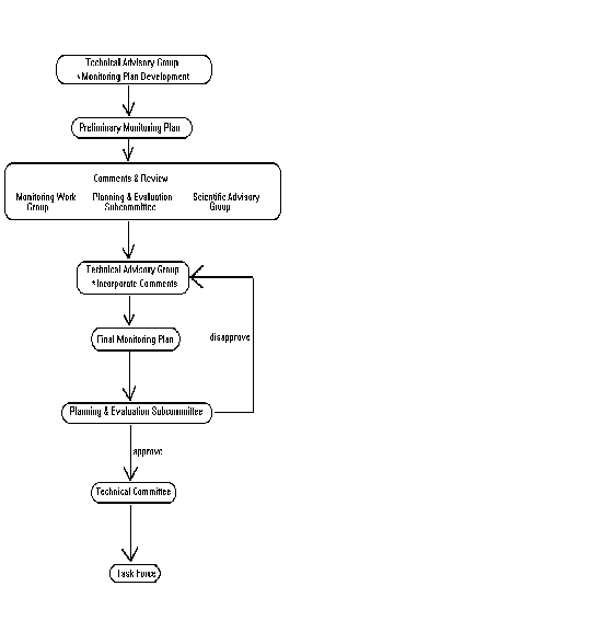
Monitoring plans undergo a thorough development and review process prior
to finalization and acceptance. The following steps are initiated in completing
a monitoring plan:
A. The monitoring manager is LDNR/CRD's representative on the TAG committee.
Monitoring managers have the job classification of geoscientist. The monitoring
manager should make initial contact with the LDNR/CRD project manager and
the lead federal agency representative for acquisition of historical data,
research reports, feasibility studies, WVA analyses, etc., in order to
develop project objectives, goals, reference areas, monitoring elements,
null hypotheses, and anticipated statistical analyses. The LDNR/CRD monitoring
manager should develop the preliminary monitoring plan. The following documents
should be used as templates in preparing the plan: standardized monitoring
plan format; standardized null hypotheses and statistical analyses; LDNR/NBS
joint monitoring proposal; and the CWPPRA Monitoring Program Document (Steyer
and Stewart 1992). A plan-view map of the project area should be developed
during this stage. If known, sampling stations, transect lines, etc., should
be included on the plan-view map. Once this plan is developed, it should
be reviewed by the monitoring supervisor and program manager, then sent
to the lead federal agency representative for refinement. A site visit,
travel, or meetings may be necessary with the lead federal agency representative
in order to develop a mutually agreeable preliminary plan. Once a mutually
agreeable preliminary plan is completed, a preliminary budget is prepared
by the monitoring manager. The plan developed at this stage should have
the goal of needing minimal changes to be approved by TAG.
B. Monitoring managers initially mail to the NBS/SSC representative,
ecologist, and statistician the preliminary monitoring plan, project description
report, and WVA analysis, at a minimum. A copy of the preliminary monitoring
plan only will be mailed out to representatives of the MWG and TAG.
This mail-out will be completed at least three weeks prior to a scheduled
TAG meeting. Other data or information requested should be supplied unless
it is too bulky or large to copy. Otherwise, all other project information,
documents, drawings, etc., should be brought to the TAG meeting.
C. All comments at the TAG meeting must be noted by the monitoring manager.
All areas of consensus, conflict, changes, and tasks to be completed, by
whom and when, must be noted. It is the responsibility of the monitoring
manager to type up these notes and have them sent, via FAX mail, to the
TAG representatives within two days.
D. The goal of the TAG meeting is to finalize a monitoring plan, however,
it may not be finalized after one meeting. Additional telephone calls,
FAX mail, and/or meetings may be necessary. If major changes are made during
the process, then all members of TAG must receive copies of the revised
document. Some projects may require a field trip by TAG representatives
either before or after the TAG meeting.
E. Other agency personnel are able to attend the TAG meetings on a voluntary
basis. Their input is considered but they are not a voting member.
F. Once a monitoring plan is finalized by TAG, it is sent to the Scientific
Advisory Group, MWG, and P&E Subcommittee representatives for a two-week
review. Comments received by the monitoring manager must be considered
by TAG. A justification by TAG is needed for any comments not incorporated.
G. After review comments are incorporated, the final monitoring plan
is sent to the P&E Subcommittee chairman for final approval. Attached
to the final plan are all comments received during review, a written response
to comments, and a proposed budget. It is the responsibility of the P&E
Subcommittee chairman to submit the final monitoring plan to the Technical
Committee and Task Force.
H. Once a monitoring plan is developed, it is the responsibility of
LDNR/CRD and NBS/SSC to implement the plan following the procedures outlined
in this Quality Management Plan (QMP).
I. The implementation of the monitoring plan will be dependent on project
construction timetables. In cases where a project is delayed because of
unforeseen causes, the monitoring activities timetable will be adjusted
accordingly.
I.1.4 Program Implementation
The development and implementation of monitoring plans require a significant
amount of management oversight and inspection. Monitoring managers (geoscience
specialists) meet with their supervisors on a monthly basis to discuss
individual projects, job performance, quality control procedures, and to
plan for the following month. Each employee then provides his supervisor
with a list of items that were agreed to in the meeting, which is subsequently
used as a guide throughout the month. This list of items is then used as
an outline in the subsequent meeting to ensure that issues raised in the
previous meeting were addressed during the month. Field trip reports are
generated for each field trip that addresses both logistical and biological
components and identifies any problems encountered. Field procedures and
any quality control items are also discussed during monthly meetings with
supervisors to ensure that each employee is familiar with standard operating
procedures and that problems encountered in the field are not recurring.
Inspection oversight is conducted by the Geoscience Program Manager and
the QA Auditor.
Procedures for field and office protocols within the Biological Analysis
Section (BAS) have been developed and implemented through the issuance
of a BAS Policies and Procedures Manual compiled by the Geoscience Program
Managers. Standard office protocols for the LDNR/CRD are utilized where
applicable and specialized protocols have been developed under the direct
supervision of Geoscience Program Managers. Specialized policies are developed
when certain procedures become frequent enough to warrant the Geoscience
Program Managers' attention. Departmental policies that are periodically
updated by upper management and new policies that are developed by Geoscience
Program Managers are introduced and reviewed at monthly staff meetings.
I.1.5 Approach
The CWPPRA Monitoring Program develops monitoring plans and collects
data on individual projects based on specific project goals and objectives.
The framework on which the plans are developed is based on a basin level
approach. All monitoring efforts are coordinated within each hydrologic
basin in order to adequately address secondary or cumulative effects of
projects.
I.1.6 Deliverables
The CWPPRA Monitoring Program will generate data on all implemented
projects under CWPPRA. Results from these projects will be published in
progress reports three times a year and in reports to the U.S. Congress
and Louisiana Legislature not less than three years after the completion
and submission of the restoration plan, and at least every three years
thereafter. The due dates may change based upon project construction timetables.
Program level documents will also be generated as outlined below.
A. The CWPPRA Program Effectiveness Report will be completed by October
1, 1996, and updated every three years until October 1, 2017.
B. The status and assessment of the CWPPRA Monitoring Program will be
completed by October 1, 1996.
C. The CWPPRA Monitoring Program Atlas will be completed by October
1, 1997, and updated every five years until October 1, 2017.
I.2 Management and Organization
The importance of a sound Quality Assurance (QA) Program is acknowledged
by CWPPRA and is addressed in CWPPRA's overall program goals. It is the
specific policy of LDNR/CRD and NBS/SSC that all environmentally related
measurements are of known and documented quality. This level of assurance
is necessary because of the vast quantities of data collected by numerous
entities. These data will ultimately assist in a decision regarding project
and program-level effectiveness, therefore, it is critical that this information
is of the highest quality.
CWPPRA has dedicated resources to the monitoring program for 20 yr.
These resources will provide the commitment for the continued development
and improvement of the monitoring program as technologies advance and protocols
are improved upon. Necessary training and technical support will be afforded
to meet program needs. Quality control (QC) checks have been provided throughout
the program to minimize impacts on data quality and integrity and to identify
problems that could influence program implementation. Any situation that
compromises data quality will be identified and addressed immediately.
It is understood that the QMP is a "living" document that
will evolve over time. Any changes to the QMP will be distributed to all
individuals performing work under the QMP as the change occurs, and these
changes will be reviewed during the annual Field Methods training. If significant
changes are made, a revised version will be published and distributed.
Quality assurance training and evaluation will be conducted annually to
assess the effectiveness of the Quality Management System, both organizationally
and procedurally.
The team responsible for the implementation of the monitoring program
and Quality System is identified in the organizational chart in figure
3.
QA responsibilities are dispersed throughout all levels of the organization.
However, specific oversight and management of QA activities are carried
out by three authorities: QA Officer (Geoscience Specialist III), QA Auditor
(Contract Wetland Ecologist,) and QA Manager (Geoscience Manager).
The QA Officer is responsible for assuring compliance of daily QA activities and reporting problems immediately to the QA Manager. The QA Auditor performs an independent evaluation of activities annually in order to provide management oversight to maximize the success of the QA activities. The
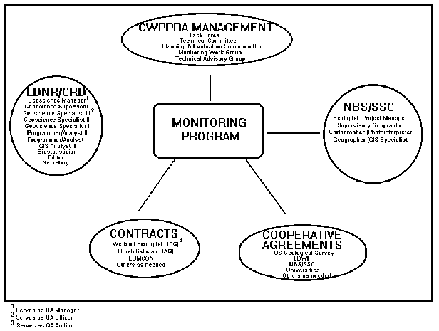
Figure 3. Illustration of teams responsible for implementation
of monitoring program.
QA Auditor reports directly to the QA Manager and provides a written
quality assurance report annually to the QA Manager. The QA Manager will
keep the P&E Subcommittee, Technical Committee, and Task Force informed
about quality issues, and has complete authority and accountability for
the QA program.
I.3 Quality Management System
The Quality Management System of the Monitoring Program is nested inside
a larger Quality Management System for the entire CWPPRA process (figure
1). At the largest scale, quality is assured by the Project Selection Process;
i.e., only projects with a high likelihood of success and large increases
in wetland function relative to cost are selected for implementation. Likewise,
the Monitoring Program is the quality control system of CWPPRA activities.
The Monitoring Program is so vital to the achievement of the CWPPRA mandates
that the program itself is the subject of this Quality Management Plan.
Activities outside the Monitoring Plan, such as the Project Selection Process
and deciding when to modify or abandon a particular project, are not within
the scope of the Monitoring Program and the Quality Management System described
in this document. Instead, the Quality System described in this document
is designed to provide a review process of the Monitoring Program. This
Quality System is as young as CWPPRA and is still evolving.
Monitoring is more critical to the success of CWPPRA than to traditional
mitigation programs because large spatial scales and uncertainty regarding
the status of the wetlands at any given time preclude the use of repeated
trial and error, which is allowed in the Clean Water Act, Section 404,
process. Instead, monitoring plans prepared by this Monitoring Program
will be designed with the expectation that some projects will be less effective
than others to facilitate learning from all projects, regardless of their
success. This monitoring philosophy is a departure from traditional monitoring
programs in which documenting effectiveness of a project is the goal of
monitoring, and understanding why and how a project was effective (or not)
is of minor importance. Thus, the monitoring philosophy behind the CWPPRA
Monitoring Program is based on adaptive management (Boesch et al. 1994)
and feedback monitoring (Gray and Jensen 1993). Consequently, the Monitoring
Program not only detects unsuccessful projects, but also provides other
CWPPRA working groups with a basis for improved project designs and operation.
Determining the effectiveness of CWPPRA projects in creating, restoring, protecting, and enhancing coastal wetlands in Louisiana is a daunting task because spatial and temporal variability cause differences between reference and project areas that hinder traditional experimental design and statistical techniques (Underwood 1994). The temporal variability and large spatial variability across the Louisiana coastal zone in wetland loss rates not only reduce the value of traditional experimental design and statistical techniques but also require a monitoring approach with a high degree of flexibility if the effectiveness of management actions under different environmental conditions are to be detected (Boesch et al. 1994). Thus, the Monitoring Program is designed not only to detect unsuccessful projects, but also to provide a basis for improved project designs and operation. The data generated from the Monitoring Program will be used to refine decision criteria and improve the level of accepted decision error. This will improve the quality of results and confidence in management decisions.
Management of all monitoring activities is the responsibility of LDNR/CRD,
however, QC responsibilities (i.e., verifying that all decisions and practices
will result in quality data) are shared by senior staff members. QC is
consolidated under the QA Manager who has final QC authority.
A critical early step by MWG was the development of rigorous, standardized
protocols that could guide the monitoring of projects (Steyer and Stewart
1992). That document was prepared with the input of the academic community
and categorized project types, goals, biological variables, and standardized
data collection methodologies. Its use by project managers ensures that
project monitoring plans will dictate the proper variables to be monitored,
along with proper sampling methods, proper sampling frequency, and appropriate
statistical tests.
MWG verifies that project monitoring plans were designed according to
the standardized protocols and that deviations from the protocols will
not alter the ability to draw conclusions on the effectiveness of the project
at protecting or restoring coastal wetlands. After verification by MWG,
project monitoring plans are finalized by TAG and submitted to the P&E
Subcommittee.
A technical audit will be conducted annually by a consulting wetland
ecologist (QA Auditor) from the academic community. The primary focus of
the technical audit is to verify that instructions laid out in the monitoring
plans are being followed. Field collection methods, data handling methods,
data analyses methods, and prepared project monitoring reports will be
audited.
A program audit will be conducted annually by the QA Manager and periodically
by the chairman of the P&E Subcommittee. The primary focus of this
audit is to verify that the management decisions made by TAG and the Program
Manager advance the goals of the Monitoring Program. This audit will use
the benefit of hindsight to determine if policies should be re-evaluated.
TAG and the Program Manager will use the technical and program audits to
revise monitoring activities.
An accessible data base of temporal and spatial monitoring data, maintained
by the State of Louisiana, will encourage the publication of monitoring
results so that the ecosystem management techniques developed in Louisiana
can be made available to and be peer reviewed by a national and international
audience. Peer review is a final step to verify that monitoring plans provide
the data necessary to determine the effectiveness of projects.
II. PERSONNEL
CWPPRA provides for the selection of approximately 5-15 projects each
year for implementation. A priority list of projects has been approved
each year since 1991 and will continue through 1995. Pending availability
of funds, additional project lists may be approved for implementation.
With the approval of each successive priority list, monitoring responsibilities
increase and personnel requirements expand. LDNR/CRD assures that adequate
staffing levels will be provided to meet monitoring responsibilities.
II.1 Qualifications
The broad range of ecological data collected in the monitoring program
requires a diversity of expertise in the collection, analysis, and interpretation
of such data. Personnel within the program have specialties in the following
areas: estuarine ecology, wetland ecology, coastal processes, wildlife
and fisheries science, plant and soil taxonomy, hydrology, water quality,
geography, and statistics. Most personnel on-board have graduate degrees.
All personnel who conduct data collection are familiar with basic wetland
ecology or biology. Appendix A includes position descriptions and qualifications
of all personnel involved in the program. Tables 2a and 2b list current
personnel involved in the monitoring program.
II.2 Training
II.2.1 Field Methods
Field data required by project monitoring plans will be collected by
geoscience specialists stationed at regional field offices or the LDNR/CRD
Baton Rouge office of the Biological Analysis Section. Qualifications for
those positions are given in appendix A. All geoscience specialists will
attend an annual Field Methods meeting where personnel will practice standardized
techniques to ensure adequate training. Personnel will practice using all
field gear including, but not limited to, Global Positioning Systems (GPS)
(section V.6), continuous data recorders, dissolved oxygen meters, velocity
meters, soil redox electrodes, soil coring devices, salinometers, staff
gauges, and transit levels. Personnel will practice collection and handling
techniques of biomass plots, soil samples, water samples, and fishery samples.
Personnel will practice species identification of all common emergent and
submersed plant species and visually estimating distance and cover. The
meeting will be conducted over 3-5 days and be developed and directed by
the Geoscience Program Supervisor with assistance from the Geoscience Program
Manager and the academic community. The Geoscience Program Supervisor will
identify academic trainers and appropriately certified instructors and
will be responsible for ensuring that all instructors and materials are
current for any particular training under sections II.2.1-II.2.5 before
that training is administered. Training will be verified by testing at
the conclusion of the Field Methods meeting and via Louisiana Civil Service
evaluations. The course will be evaluated
Table 2a. Biological Analysis Section staff and their positions as of April 1, 1995.
EMPLOYEE |
|
Steyer, Gregory |
|
Underwood, Steve |
|
Libersat, Ralph |
|
Webb, Eric |
|
Raynie, Rick |
|
Vacant |
|
Alonzo, Al |
|
Holbrook, Shannon |
|
Vacant |
|
Vincent, Karl |
|
Beasley, Marty |
|
Haywood, Edward |
|
Kelley, Suzanne |
|
Miller, Charles |
|
Rhinehart, William |
|
Steller, Diana |
|
Weifenbach, Dona |
|
Carriere, John |
|
Cheramie, Vincent |
|
Thibodeaux, Christine |
|
Sun, Bin |
|
Olinde, Margo |
|
Oswald, Elfrieda |
|
Table 2b. National Biological Service, Southern Science Center, Analysis Section staff and their positions as of April 1, 1995.
EMPLOYEE |
|
Fuller, Deborah and Johnston, James |
|
Handley, Lawrence |
|
Greco, Robert |
|
Seeger, Eric |
|
Jones, William |
|
by geoscience specialists and comments will be provided to training
personnel as part of the quality improvement process.
II.2.2 Laboratory Methods
All personnel who conduct routine laboratory procedures will attend
an annual Laboratory Methods meeting where personnel will review standard
laboratory practices related to the handling and measurement of samples
for soil bulk density, dry weight of soil and vegetation samples, soil
organic matter content, and water salinity. Laboratory training related
to more complicated or less used techniques, or techniques requiring the
use of hazardous materials, will not be conducted because those analyses
will be contracted to commercial and academic laboratories. Personnel will
be trained, however, in the preparation of spiked samples that will be
sent to contract laboratories to verify the quality of those analyses.
The Laboratory Methods meeting will be developed and directed by the Geoscience
Program Supervisor with assistance from the Geoscience Program Manager
and the academic community and will generally be conducted concurrently
with the Field Methods meeting. Training will be verified by testing at
the conclusion of the meeting and via Louisiana Civil Service evaluations.
The course will be evaluated by geoscience specialists and comments will
be provided to training personnel as part of the quality improvement process.
II.2.3 Data Processing and Analysis Training
All personnel who conduct data processing and analysis will attend training
in the use of relevant software packages.
Spatial data are processed by NBS/SSC via a cooperative agreement with
LDNR/CRD. Their training is described in a Standard Operating Procedures
(SOP) document (NBS n.d.).
Nonspatial data are processed by the Biological Analysis Section, LDNR/CRD.
Data will be processed and analyzed by geoscience specialists trained in
the use of ORACLE, EXCEL, WordPerfect®, and SAS software
by experienced geoscience specialists and Information Systems Applications
Programmer/Analyst 1. Training will be developed and directed by an Information
Systems Applications Programmer/Analyst 2 and verified by a biostatistician,
geoscience supervisor and via Louisiana Civil Service evaluations.
II.2.4 Safety
Safety training is a critical component of the monitoring program due
to exposure to potential hazards in land, sea, and air. All personnel will
be required to attend safety training every three years. The following
is a list of types of trainings required in this program:
A. Water safety and boat handling: U.S. Coast Guard-approved
boat safety training required of all field personnel involved in boat operation.
B. Airboat training: Eight hours of airboat training, including
operation, by a qualified airboat operator.
C. First aid and CPR: Mandatory for field personnel and encouraged
for office personnel.
D. All-terrain vehicle (ATV): Eight hours training by a certified
instructor in the safety and use of an ATV before operation.
E. Aviation Safety Training: NBS/SSC employees flying special
use missions or serving as aircrew members must have OAS Aviation User
training every three years. NBS/SSC policy requires pinch-hitter training
and certification for employees flying regular missions on projects.
F. Laboratory Safety Standards: Training and certification required.
II.2.5 Technical and Project Management
All personnel having technical and/or project management responsibilities
will initially attend introductory project management training upon accrual
of these duties. The training will be developed and directed by the Geoscience
Program Supervisor with assistance from the Geoscience Program Manager.
Continual training will be required as additional responsibilities are
accrued.
II.2.6 Professional Development
All personnel will be encouraged and solicited to make presentations at scientific and professional meetings. Personnel are required to stay current in the scientific literature and are encouraged to seek additional scientific/academic training. Professional development is also maintained through the state of Louisiana 's Certified Public Training Program.
III. PROCUREMENT OF EQUIPMENT, SERVICES, AND SUPPLIES
III.1 Contract and Purchasing Procedures
LDNR/CRD Program Managers have the responsibility of acquiring services
needed to fulfill all the obligations and requirements of the monitoring
program. LDNR/CRD has an administrative staff that is responsible for administering
contracts and legally binding agreements through which LDNR/CRD acquires
or renders all goods (deliverables) and/or services.
LDNR purchasing, individually and in conjunction with other state entities,
operates under various statutes (Louisiana Revised Statutes [LRS]); administrative
codes (Louisiana Administrative Codes [LAC]); and Executive Orders. The
documents pertinent to procurement of equipment, services, and supplies
include, but are not limited to:
1. LRS 39, Chapter 17, Louisiana Procurement Code
2. LAC 34, Part I, Rules and Regulations
3. Executive Order EWE 92-53 (small purchases)
4. LRS 38:2211 et al., Chapter 10 (construction/public works-letting bids)
5. LRS 39, Chapter 19 (Louisiana Minority and Women's Business Enterprise
Act)
The administrative staff have extracted and simplified these documents
to provide in-house guidelines (unpublished Policy and Procedural Memoranda)
that identify procedures to be followed to adequately track and manage
contracts. The completed codification of procedures, however, appears in
the above listed documents. Specific guidelines include, but are not limited
to: (1) requests for contracts and amendments, (2) billing and invoices,
(3) selection of vendor, (4) contracting party requirements, and (5) purchasing
process. Checklists are provided to ensure submission and routing of appropriate
information to minimize contracting and purchasing problems. The administrative
staff are expected to, at a minimum:
1. Review and track all significant paperwork, including: project narrative;
scope of services; budget; request for contracts and amendments or proposals;
purchase and change orders; invoices; payments; ensure dual sign-off where
needed for technical and administrative review; and ensure all commitments/requests
of any kind are in writing and by the appropriate persons.
2. Ensure complete documentation and filing of all significant documents,
correspondence, and other information.
3. Coordinate, develop, or initiate correspondence, written alternatives,
recommendations, responses, and preventative actions to project concerns/problems.
4. Prepare postassignment reports on all projects and contracts when
completed.
5. Inquire and arrange for orderly transfer of project/contract management
responsibilities.
6. Ensure that minority/disadvantaged business enterprises have the
maximum opportunity to compete for and perform contracted services.
7. Personally inspect all purchases and deliverables and verify whether
they are satisfactory and in keeping with the terms and conditions of the
contract. Authorization or payment of invoices should not be processed
until deliverables are in-hand or documented.
8. In the case of contracted facilities or laboratories, monitoring
reports are provided by the contractor at the time of invoicing and reviewed
by LDNR/CRD program managers for compliance and provided to the administrative
staff. The LDNR/CRD program managers complete a performance evaluation
form at the end of the contract period and provide this to the administrative
staff. The review of the contractor includes evaluating compliance with
LDNR/CRD standards and the contract conditions and deliverables.
IV. QUALITY ASSURANCE OBJECTIVES
IV.1 QA Mission Statement
The objective of this QMP is to define and assure that processes involved
in the implementation of the monitoring program meet QA and QC requirements
of CWPPRA. The QA Mission is to certify that all data collected in this
program meet the quality objectives defined below, and that CWPPRA management
will support decisions necessary to meet the level of detail described
in this QMP.
IV.2 Measurement Quality Objectives
Introduction
QA methodology, as set forth in this QMP, is used to ensure that the
QA Goals outlined in this section are met. All participants must be impressed
from the beginning with the importance of maintaining a commitment to QC
throughout the program. Training field personnel is an important part of
QC. All personnel must be familiar with the procedures to be used, and
confident in their ability to use the equipment, and that those procedures
used are standardized among personnel to keep errors associated with data
collected by different people to a minimum. Field and laboratory personnel
must be given the opportunity to assess procedures and to suggest improvements.
The Standard Operating Procedures for each method are discussed in detail
in section V. This section presents only general QA considerations.
Measurement of quality objectives will be determined from manufacturer
specifications, analytical methods, and the judgment of experts (if required).
The five general quality objectives are discussed below.
Accuracy
Accuracy is the degree to which a measured value agrees with an accepted
known value (Taylor 1988). Bias is the systematic error inherent in a method
or caused by a particular measurement device. Accuracy will be assessed
through the use of standards (manufacturer supplied) whenever such standards
exist. Internal standards will be devised for methods where a commercially
available standard does not exist. Accuracy is also ensured by field training
to be sure that all personnel follow the same procedures.
Precision
Precision is a measure of scatter among repeated independent observations
of the same property under controlled similar conditions (Taylor 1988).
Precision in the field will be assessed by replicate measurements. Laboratory
method precision will be estimated by repeating measurements of a sample
standard. The sample precision will be estimated by repeated measurement
of a sample or sample split.
Representativeness
Representativeness, or the degree to which data truly characterize a
population or environmental condition (Stanley and Verner 1985, Smith et
al. 1988), will be assessed by the use of the replicate samples. In the
laboratory multiple subsamples will be made, and each of the subsamples
will be analyzed in order to determine its variability. This will allow
for the calculation of the number of laboratory subsamples needed to adequately
describe the field sample.
Representativeness of the environment can only be assessed by examining
both the temporal and spatial variability on a given project area. Environmental
variability is usually estimated by collecting replicate samples (randomly
chosen) over space and time. However, randomly selected samples may not
adequately characterize a study area unless a large number of replicates
are collected. Where spatial variation within a study area is evident,
stratified random sampling may be employed. Temporal variation may be accounted
for by restricting sampling to comparable time periods.
Comparability
Comparability is the degree of confidence with which data sets may be
compared. Comparability will be ensured for laboratory analyses through
the use of standard methods for which there is a known accuracy and precision.
Comparability of field data sets will be accomplished by ensuring that
the same procedures are followed by all sampling personnel. This is accomplished
through the use of SOPs and proper training in field and laboratory techniques.
Completeness
Completeness, which is the ratio of the amount of valid data obtained
to the amount expected (Stanley and Verner 1985, Smith et al. 1988), will
also be used as an overall index for the program. If the completeness is
not high enough the evaluation of a project may be compromised. Completeness
for an individual project is defined as the amount of data and samples
actually collected as a percentage of the amount of data and samples assigned
to the monitoring effort when monitoring begins.
IV.3 Quality Assurance Goals
The quality assurance goals are summarized in table 3, which will serve
as the overall guideline for the monitoring program by presenting, for
each variable to be monitored, the accuracy, precision, and completeness
goals as well as the expected range of values to be encountered. The variables
to be monitored and the exact method by which each of these goals will
be met for an individual project will be outlined in the project monitoring
plan. However, the individual project plan must demonstrate that the goals
listed in table 3 will be met. Table 4 lists the types of QC samples that
will be employed.
Table 3. Quality Assurance Goals and expected ranges. Accuracy is in absolute units where possible; precision is based on the difference between replicated measurements. Percentages in the accuracy and precision goal columns represent tolerable error. The precision goal refers to individual measurements as well as between sampling crews. Data collected outside the expected range may be real but should be verified.
Type of Measurement Units Accuracy Precision Completeness Expected
Goal Goal Goal Range
1. Habitat Mapping
Photointerpretation habitat 7% NA 100% NA
Photoregistration m 15 m NA NA NA
2. Meteorological and Hydrologic Sampling
Precipitation cm/h 10% 5% 85% 0-15
Wind Speed m/s 0.7 m/s 0.5 m/s 85% 0-5
Wind Direction degrees 5 degrees 5 degrees 85% 0-360
Water Level (Stage) cm 1.0 cm 1.0 cm 85% -50-200
Salinity ppt 0.75 ppt 0.5 ppt 85% 0-36
Conductivity millsiemens 15% 10% 85% 0-50
Temperature centigrade 0.5 C 0.2 C 85% 5-35
pH pH units 0.2 0.1 85% 6-8.5
Discharge
Current Speed m/s 0.1 m/s 0.1 m/s 85% 0-2
Cross-Sectional Area m2 5% 5% 85% 0-500
Suspended Sediments mg/L 2 mg/L 2 mg/L 85% 0-200
Bathymetry cm 4.0 4.0 85% -200-0
Topography cm 4.0 4.0 85% -90-90
3. Soil/Sediment Sampling
Redox mV 20 mV 20% 85% -200-200
Percent Organic Matter % 10% 15% 85% 0-100
Bulk Density g/cm3 0.1 g/cm3 15% 85% 0.01-0.90
Percent Water % 10% 15% 85% 0-100
Salinity ppt 0.75 ppt 0.5 ppt 85% 0-50
Sulfides ppm 100 ppm 25% 85% 50-150
Grain Size microns NA 30% 85% 0.2-500
4. Surveying (horizontal)
GPS m 3 m 3 m 85% 0-300
Conventional m 0.3 m 0.3 m 85% 0-300
Table 3. (continued)
Type of Measurement Units Accuracy Precision Completeness Expected
Goal Goal Goal Range
5. Vertical Accretion
Feldspar cm 0.1 cm 30% 85% 0-2
SET Table cm 0.1 cm 30% 85% 0-2
Radionuclide cm 0.5 cm 30% 85% 0-2
6. Subsidence
From Tide Gauges cm/yr 0.5 cm/yr 0.5 cm/yr 85% 0-2
From C-14 Dating cm/yr 0.5 cm/yr 0.5 cm/yr 85% 0-2
From Extensometers cm/yr 0.5 cm/yr 0.5 cm/yr 85% 0-2
7. Marsh Erosion and Soil Creation
Large Scale m 2 m 2 m 85% 0-100
Small Scale cm 5 cm 5 cm 85% 0-200
8. Vegetative Health
Species Composition and relative abundance
Taxonomic ID species 10% NA 85% NA
Percent Cover % 10% 10% 85% 0-100
Number of Stems number/m2 10% 10% 85% 1-2,000
Aboveground Biomass
Clip Plots g/m2 20% 20% 85% 0-2,000
Stem Length cm 10% 20% 85% 1-200
9. Herbivory % 10% 10% 85% 0-100
10. Fisheries Sampling
Taxonomic ID species 10% NA 85% NA
Organism Counts numbers 10% NA 85% NA
Size mm 1 mm 1 mm 85% NA
11. Water Quality Sampling*
a) NH4 mg/L 15% 15% 85% 0.4-40
b) NO3 mg/L 15% 15% 85% 1-100
c) NO2 mg/L 15% 15% 85% 0.1-10
d) Ortho P mg/L 15% 15% 85% 0.2-3
Table 3. (continued)
Type of Measurement Units Accuracy Precision Completeness Expected
Goal Goal Goal Range
e) Organic Carbon mg/L 15% 15% 85% 5-200
f) Volatile Organic Cs ug/L 15% 15% 85% Unknown
g) Pesticides ug/L 15% 15% 85% Unknown
h) Herbicides ug/L 15% 15% 85% Unknown
i) Insecticides ug/L 15% 15% 85% Unknown
j) Triazines ug/L 15% 15% 85% Unknown
k) Carbamates ug/L 15% 15% 85% Unknown
l) Priority Pollutants ug/L 15% 15% 85% Unknown
m) PCBs ug/L 15% 15% 85% Unknown
n) Dioxins ug/L 15% 15% 85% Unknown
* Accuracy and precision goals are dependent on detection level. The following are various detection limits for the nutrients and priority pollutants identified above: (a-d) 0.01-0.001 mg/L; (e) 0.1 mg/L; (f) 3 -0.2 mg/L; (g-h) 0.1-0.01 mg/L; (i) 0.1-0.001 mg/L; (j) 0.2-0.05 mg/L; (k) 0.5 ug/L; (l) 1-0.001 ug/L; (m) 0.1-0.001 ug/L; and (n) 0.001-0.0001 ug/L. Organic compounds are qualified by the percent recovery of the extraction procedures. The U.S. Geological Survey and U.S. Environmental Protection Agency typically consider extractions with efficiencies of 30%-140% as acceptable.
Table 4. Summary of QC samples and procedures to be used. Indicated
for each type of QC is the purpose for which it is to be used (R = Representativeness,
A = Accuracy, P = Precision, C = Comparability).
Type of QC Sample Purpose
Field and Laboratory Standard Methods R, C
Field Replicates at a Sample Location
Spatial R, C
Temporal R, C
Reference Sites R
Laboratory Replicates
Sample Splits R, C
Replicate Field Samples R, C
Laboratory Standards
Multiple Standards (i.e., 5-point calibration) P, A, C
Blanks P, A, C
IV.4 Assessment of Measurement Quality
Periodic QC checks are necessary to ensure that all measurements made
will be reliable. Such checks are performed throughout all stages of field
sampling, laboratory preparation, and data analysis. Internal checks will
be made on no less than 10% of the samples taken, or measurements or estimates
recorded. Field QC checks will consist of discussions with the sampling
personnel to ensure that all personnel are following the standard field
procedures. Each individual must demonstrate consistency and accuracy for
the measurement technique during training. Sufficient training of each
individual will ensure comparability among individuals and sample sites.
In addition, replication of field sampling will allow for an estimate of
precision of the field and laboratory procedures.
The formulas discussed below outline the basic methodology for the calculation
of each of the five QA objectives. It should be pointed out that these
are not the only means that will be employed in assessing the QA objectives.
The monitoring plan for each individual project may, depending upon project
type, outline alternate methods of assessing the QA objectives. In all
cases, the methods used will be reviewed to ensure that they are statistically
valid.
1. Accuracy can be assessed by the relative percent difference between
the measured value and the true value, as set by a standard, using the
following formula:
% difference = | true value measured value | x 100
true value
In cases where more than two samples are involved (multiple readings
of a standard), the relative standard deviation (RSD) that is the coefficient
of variation (CV) expressed as a percentage can be used (Taylor 1988):
CV = standard deviation / mean
RSD = CV x 100
2. Precision, Representativeness, and Comparability, when based on analysis
of replicate samples, will use the following formula for comparing two
samples (or two subsamples of a given sample) as A and B:
% difference = | A B | x 100
(A + B) / 2
In cases where there will be more than two replicates, the coefficient
of variation can be used.
3. Completeness will be assessed by the percent of data collected as
a percentage of the number of proposed samples to be collected and will
be determined by the following formula:
% complete = | samples collected proposed samples | x 100
proposed samples
Data quality will be assessed using the above general principles along
with the Quality Assurance Goals. During analysis the geoscience specialist
or laboratory analyst will keep track of the standard, blank, and replicate
readings each time samples are measured to ensure that the values fall
within the guidelines. If values fall outside the guidelines, a decision
will be made by the geoscience specialist in consultation with the geoscience
supervisor regarding the acceptability of the error.
V. STANDARD OPERATING PROCEDURES
V.1 General Considerations
Introduction
Monitoring standard operating procedures (SOP)
provides an established method that can be followed to direct the development
and implementation of project-specific monitoring plans. Steyer and Stewart
(1992) developed a plan to provide these procedures. The SOPs described
in this QMP are taken and expanded from Steyer and Stewart and they describe
in greater detail the QA/QC measures employed with each procedure. The
SOPs were written by the CWPPRA Monitoring Work Group and refined by LDNR/CRD
geoscience specialists and the academic community. Other SOPs not covered
in the Steyer and Stewart (1992) document were written by academic experts
contracted by the Geoscience Program Manager. All SOPs are reviewed and
revised (if necessary) annually by the geoscience supervisors upon approval
by the QA Manager. The information provided in each document will have
some redundancy but should also compliment each other.
Project Types Requiring Monitoring
Under Act 6 and CWPPRA, all projects were categorized
into nine types: freshwater introduction and diversions, sediment diversions,
marsh management, hydrologic restoration, beneficial use of dredged material,
shoreline protection, barrier island restoration, vegetative planting,
and sediment and nutrient trapping.
A critical step in establishing a successful monitoring
program is to define the goals used to conduct the monitoring. If the goals
are poorly defined, there will be no guidance in the establishment of protocols.
CWPPRA requires an evaluation of the effectiveness of each project in achieving
its specific goals directed towards creating, restoring, protecting, and
enhancing coastal wetlands. For example, a project using dredged material
may be built to reduce wave energies and consequent physical erosion, or
develop a new soil and sediment base at a proper elevation to restore or
maintain vegetated marsh. Each of these projects begins with a hypothesis
or set of hypotheses related to the expected change in physical, biological,
or chemical variables of the project area. These hypotheses then guide
the monitoring program as to which variables will be monitored and how
frequently.
Freshwater Introduction and Diversion
Freshwater introduction and diversion projects
are designed to introduce fresh water and alluvial material from available
sources to shallow marsh estuaries. Areas targeted for freshwater diversion
projects are characterized by saltwater intrusion, sediment subsidence,
and shoreline erosion. The primary goal of these projects is to enhance
wetlands by increasing the use of fresh water, nutrients, and sediment
that will be provided by the freshwater diversions. Management of the outfall
will route the fresh water through the wetlands and provide greater deposition
of sediments in the marsh to offset subsidence, greater availability of
nutrients to vegetation, and a more gradual release of fresh water to the
benefit of wildlife, fish, and shellfish. Monitoring freshwater diversions
will help to determine if any changes or modifications are needed in the
operation.
Sediment Diversion
Sediment diversions are projects that increase
deposition of river-borne sediment in shallow bay areas that cannot keep
pace with subsidence through sediment accretion. A small-scale sediment
diversion project is designed around the concept of natural crevasse splay
development. Where a breach occurs in the bank of a river, sediment infilling
begins within the surrounding distributary bays, and crevasse splay sediment
eventually becomes subaerial and established with marsh vegetation. Large-scale
sediment diversions on the Mississippi River are designed to be similar
to the large natural crevasses such as the one at Baptiste Collette, La.
The primary goal of the project is to create and manage crevasses through
the natural levee ridges of rivers and major distributary channels so that
the natural land-building process can create emergent and submergent aquatic
communities critical to the overall productivity of the deltaic systems.
Monitoring of sediment diversions will help to determine the management
of the crevasses.
Marsh Management
In marsh management projects, structures actively
manipulate local hydrology to control water levels and salinity, while
concurrently allowing ingress and egress of marine organisms. Marsh management
plans generally incorporate existing canal spoil banks, the construction
of short levees to connect these spoil banks, the installation of water
control structures, and/or the construction of pump and other control structures
to introduce fresh water into the managed area and keep out saline water.
The main goals of marsh management are to minimize the loss of and promote
the growth of emergent and submergent plant communities by reducing salinities,
stabilizing water levels, and restricting tidal exchange. Monitoring of
marsh management projects will help determine operation schedules for pumps
and structures.
Hydrologic Restoration
Hydrologic restoration projects typically try
to reestablish former hydrologic pathways and flow regimes, with the goal
of redistributing fresh water to influence water levels and salinity. Specifically,
hydrologic restoration tends to reduce rapid tidal fluctuations and improve
freshwater retention. These manipulations of the local hydrology will aid
in the reestablishment of emergent and submergent plant communities. Monitoring
will help determine hydrologic effects on biological resources.
Beneficial Use of Dredged Material
Open-water bodies and navigational channels are
often sources of dredged sediment material that could be beneficially used
to create vegetated wetlands or to restore areas of deteriorating marsh.
Sediment can be pumped into confined or unconfined areas to a height conducive
to marsh development. Once the dredged material settles, growth of emergent
vegetation can be promoted. Monitoring will help determine the applicability
of this technique for marsh creation.
Shoreline Protection
Shoreline protection projects use structural and
nonstructural measures such as breakwaters, bulkheads, revetments, longyard
tubes, wave-damping fences, and levees to reduce wave energies and erosive
action. Critical shoreline areas threatened with hydrological breaches
could be protected to prevent wave erosion and water exchange from jeopardizing
the physical integrity of the shoreline and adjacent marshes. Vegetation
could also be incorporated into the shoreline protection design to create
habitat as well as an additional erosion buffer. Monitoring will help determine
the effectiveness of different shoreline protection techniques in reducing
wave erosion and in creating wetland habitat.
Barrier Island Restoration
Barrier islands provide protection to backbarrier
bays, estuaries, and marshes. This protection includes reduction of erosional
effects and wind and wave energies, dissipation of storm surges, and prevention
of saltwater intrusion. Over the last century, Louisiana's barrier islands
have been reduced by approximately 40%, resulting in loss of habitat and
protection for the coastal mainland. Barrier island restoration projects
are needed to reestablish this natural protective zone. Barrier island
restoration projects include creation of barrier islands or augmentation
of existing islands. The objectives of these projects are to increase the
height and width of the barrier island and close any shoreline breaches
by using dredged materials and vegetation. Monitoring will help determine
the effectiveness of restoration and creation techniques.
Vegetative Planting
Vegetative planting projects are designed to introduce
suitable plant species into deteriorating marsh areas and along eroding
shorelines to provide a buffer against erosive wave action. Vegetative
plantings also provide many other functions such as sediment stabilization,
sediment trapping, and habitat value. Monitoring will help determine the
success and effectiveness of different vegetative planting techniques in
reducing wetland erosional loss and in creating wetland habitat.
Sediment and Nutrient Trapping
Sediment and nutrient trapping projects use structural
devices such as brush fences or earthen berms to reduce wave energies,
promote the deposition of suspended sediment, and increase water clarity.
The goals are to reduce erosion of windward marsh edges, promote the growth
of emergent vegetation, and increase the overall productivity of the area.
Monitoring will help determine the effectiveness of different sediment-
and nutrient-trapping techniques.
Reference Areas
The importance of using appropriate reference
areas cannot be overemphasized. Monitoring on both project and reference
areas provides a means to achieve statistically valid comparisons, and
is therefore the most effective means of evaluating project success.
If appropriate reference areas are available,
they should always be included in the design to allow for interpretation
of the influence of temporal and spatial variation on projects. When monitoring
projects without a reference area(s), differences between pretreatment
means and post-treatment means may be misinterpreted. Long-term means are
often averages that do not adequately represent rates or conditions that
vary in space or time.
Selection of a reference area should ideally be
done before project initiation. Reference areas should be ecologically
similar to the project area yet located far enough away so as to not be
influenced by the project. Potential reference areas can be selected by
use of WVA methods or through more basic comparisons of structural and
functional attributes. To ensure the selection of appropriate reference
areas, an interagency team of scientists should be convened. If there is
any question concerning the similarity of the reference and project areas,
more than one reference area should be selected. Appropriate reference
areas are more likely to be found in smaller project areas.
It is recognized that in many areas of Louisiana,
appropriate reference areas cannot be identified. In addition, the extent
of wetland modification (both planned and unplanned) occurring in this
region often results in the loss of reference areas before monitoring efforts
are completed. We also recognize that occasionally, especially in the case
of very large projects (e.g., sediment diversions and freshwater diversions
from the Mississippi River or watershed projects) it may be difficult to
select reference areas that adequately reflect the same marsh type and
function as those being affected by the project. In these cases, two strategies
can be adopted:
1. Monitoring before and after project implementation.
The disadvantages of this strategy include delay in project implementation,
temporal variability, and the inability to clearly identify cumulative
impacts of the project in comparison to unaffected areas. In addition,
before and after monitoring cannot ensure that the same events are being
monitored for comparison; therefore, interpretation of the results will
be difficult. However, such monitoring would provide some indication of
project performance and impact.
2. Baseline data collection. This may be especially
important in areas where reference areas cannot be selected for monitoring.
As a "once only" data collection program, it would not delay
project implementation as much as full-scale monitoring before implementation
(as in [1] above). It would provide a datum against which changing biological
variables could be compared. In some cases, existing data bases might be
considered appropriate as baseline data. If this were to occur, an interagency
team of experts or their scientific advisors should be convened to evaluate
the suitability of the existing data bases for this purpose.
Although before and after monitoring of the project
implementation and baseline data collection do provide valuable information,
they do not necessarily provide a statistically valid evaluation of projects.
Statistical Analyses
The size of the project area, the number of different
habitats present, and the heterogeneity within those habitats should define
the number of statistical strata necessary for an analysis.
Before sampling is initiated, it is important
to determine the desired statistical power for the analysis (Fairweather
1991). This procedure involves using a variance estimate to calculate the
number of samples required to detect a percentage difference between two
means. Initially, the sample size required to achieve this power can be
estimated from sample variances reported in the literature, and these estimates
can be refined by using data collected in the reference area selection
process. It should be recognized that this power will often improve with
the use of data transformations and more complex analysis of variance (ANOVA)
designs.
Adequate characterization of environmental conditions
in project and reference areas requires that temporal and spatial variations
are addressed in the statistical design. A statistical comparison is only
valid if the statistical parameters being compared have been carefully
and adequately estimated by a sampling design that considers heterogeneity.
Randomly selected sample sites may not adequately characterize a study
area unless a large number of replicate samples are collected. Where spatial
variation within study areas is evident, stratified random sampling is
a more appropriate approach to adequate characterization. Temporal variation
may be accounted for by restricting sampling to comparable time periods.
When spatial variations within project and reference areas require replicate
sampling within environmental strata, sampling efforts among strata may
be uneven. Balance in the data set may be adjusted by weighing where sampling
efforts are not equal among strata. Habitat mapping of project and reference
areas is useful in defining weighing factors for statistical comparisons.
The adequacy of sampling may be evaluated by plotting
the behavior of means and variances against sample size. As the number
of samples approaches adequacy, the mean and variance should stabilize
(Hurtubia 1973; Pielou 1969).
Data analysis for a project may include a two-way
ANOVA with area and habitat as main effects. In the most basic design,
the null hypothesis is a two-tail test of whether the mean value for some
variable is equal between the project area and the reference area(s), or
between the preproject and postproject condition. The alternate hypothesis
should be whether the mean value for that variable at the project area
is greater or less than in reference areas or whether the preproject condition
is greater or less than the postproject condition. It is important to determine
whether the mean value for the variable increased or decreased because
of the project, taking into consideration other outside influences.
Field Data
A coding scheme will be used to identify the type of project, the project
name, the type of data, the date the data were collected, and the location
where the data were collected for each sample. The location will be provided
in either latitude/longitude or UTM coordinates. These steps are needed
to ensure that sufficient documentation exists for verification of data
accuracy. Data coding will be the responsibility of geoscience specialists
and oversight will verify that all data are properly coded to ensure compatibility
with the CWPPRA Regional GIS Data Base.
Spatial Data
All spatial data will conform to an Executive Order dated 11 April 1994,
describing standardized methods of data acquisition and access. The proper
coding of spatial data will be the responsibility of the Supervisory Geographer
and GIS Specialist to ensure compatibility with the CWPPRA Regional GIS
Data Base.
Routine QA Procedures
1. Field
For accurate data collection, necessary equipment must be in good working
order. The equipment will be checked and calibrated prior to departure
from LDNR/CRD or NBS/SSC (appendix B). Proper storage and stowage must
be practiced to prevent damage. At each site, equipment will be given a
routine check and, if necessary, calibrated before field use.
The entry of data onto a data sheet must be done accurately and neatly.
The following general guidelines will be observed and checked by the QA
Officer.
A. Ensure you are entering the correct data in the correct place on
the proper data sheet.
B. Double check sample numbers and station location ID codes when recording
data.
C. If data are entered in a nonstandard location on the data sheet,
be sure to document the reason for doing so.
D. All data are to be recorded in pencil.
E. Print all entries legibly, be sure that similar numbers (e.g., 5s,
8s, and 2s) are distinguishable.
F. Double check all entries on the data sheets.
G. Do not erase or use paper correction fluid; cross-out the entry and write the corrected number nearby and initial the cross-out. If there is not room to write the new number, write it in the margin or at the bottom of the page. Be sure to annotate all entries.
Upon completion of sampling but before departing a site, the monitoring
manager will examine all data forms for completeness and legibility. All
samples must be checked for proper identification and storage. If data
are missing or incomplete, the monitoring manager should attempt to collect
it before leaving the site. If the situation cannot be corrected, it will
be fully documented.
In the case of data readings that are outside the expected measurement
bounds (table 3), an attempt will be made to determine the cause of the
problem. The SOP will be checked for the method to be sure that the correct
procedures are being followed, and the field equipment will be rechecked
to be sure that it is functioning properly. If the field equipment is functioning
properly, record the data along with a note as to what was done. This will
help ensure that any outliers on the data set are real values, and not
due to sampling error. This procedure will also be followed on laboratory
analyses.
2. Laboratory
The following minimum criteria will be used in routine laboratory analyses
and will be checked by the QA Officer. Details of any additional criteria
for a specific variable will be discussed in the SOP for that variable.
A. Weighing Accuracy: balances will be checked by weighing standard
weights at the beginning of each batch. The number of samples in a batch
are defined in the laboratory SOP for the particular analysis. Three standard
weights will be weighed and the values recorded on the appropriate data
sheet. The values obtained must be within ±5% of the standard weights.
If the standard weights are not within 5%, stop the analysis and contact
the geoscience supervisor since it is likely that the balance needs repair.
B. Weighing Precision: determined by having 10% of the samples
from each analysis run reweighed, and the values recorded on the appropriate
data sheet. The samples are to be randomly selected. The weighings are
to be done independently and the data from the two weighings merged and
analyzed by one of the monitoring managers. The separate weightings must
be within ±5% of each other.
C. Temperature and Time Precision: analysis involving drying
and/or ashing samples for specified times and temperatures (as set forth
in the SOP for the variable being analyzed) shall have the times and oven
(or furnace) temperatures (determined with laboratory thermometer) logged
on the appropriate data sheet when a batch is placed in or removed from
the drying oven (or furnace).
D. Data Completeness: expressed as the percentage of data obtained
of the total that was possible from the analysis based upon the number
of samples brought to the lab. Data loss arises from improper storage,
illegible data sheets, or failure to follow the SOP. The program goal is
to have a data completeness value of 85% or greater.
E. Sample Representativeness: an estimate of how well an individual
analysis represents the value for the entire sample. This will be assessed
by taking three subsamples from every tenth sample. The values obtained
from the subsamples should be within the accuracy guidelines listed in
table 3.
In addition to the above general laboratory QA guidelines, laboratory
personnel are responsible for maintaining a sample custody log (appendix
B). The sample custody transfers to the laboratory when the monitoring
manager turns in the samples to be analyzed (the laboratory QA Manager
signs for the samples upon receipt). While samples are being inventoried
and analyzed, data sheets documenting receipt of samples, date of processing,
analysis results, and any problems encountered will be filled out and kept
on file. The entry of data into the laboratory notebook or onto a data
sheet must be done accurately and neatly, following the same guidelines
used for field data entry.
Samples will not be discarded until after all analyses have been performed
and the quality of the analyses checked. Should an analysis not meet the
quality guidelines, the samples will be reanalyzed.
V.2 Project Boundaries
Initial Determination Procedures
The WVA work group initially determines boundaries once a project has
been proposed for nomination as a priority project. The NBS/SSC obtains
these preliminary boundaries (delineated on various forms of base maps)
from the WVA work group. These boundaries are then digitized (either from
7.5-min quad sheets or heads-up digitizing), incorporated into an ARC/Info
data base and overlaid on thematic mapper (TM) base maps.
Final Determination Procedures
Once a reduced list of priority projects has been decided upon, a final
WVA assessment is conducted. During this process project boundaries may
be redefined or modified by the WVA work group. These modified boundaries
are then transferred to the NBS/SSC and appropriate changes made to the
data base.
The final determination of which priority projects have been approved
for the current fiscal year is determined by the CWPPRA Task Force. The
list of final projects is entered into the CWPPRA Regional GIS Data Base
housed at LDNR/CRD.
V.3 Habitat Mapping
Four dates of photography will be flown for each project. Certain types
of restoration projects (such as vegetative plantings or shoreline protection)
may only require having the aerial photography flown. Other projects (e.g.,
hydrologic restoration or marsh management), require detailed habitat mapping
in order to assess project impacts in the future. The basic goal of habitat
mapping is to provide a consistency of products by using the U.S. Fish
and Wildlife Service (USFWS) wetland classification system (Cowardin et
al. 1979) so that wetland habitat changes can be accurately assessed throughout
the project life. For those projects where detailed mapping is required,
the photography will be prepared and photointerpreted onto stable base
mylars. After the photoacquisition and photointerpretation phases, the
data will go through a digital conversion stage to be readied for geographic
information systems (GIS) analyses.
Aerial Photography
High-resolution, color-infrared aerial photography will be the primary
mapping medium for habitat monitoring. The scales of the aerial photography
are 1:12,000 or 1:24,000, depending on the project size. The level of effort
needed to establish baseline conditions, as described in each site-specific
monitoring plan, may differ depending on the project type. All of the restoration
projects will have photography flown and will have horizontal controls
established in the field using aerial targets and Global Positioning Systems
(GPS) for georeferencing. The georeferencing will be used for the development
of project base maps, photorectification, and replication of mapping for
future trend analysis.
Project areas to be flown will be identified by September 1 each year,
to the NBS/SSC Project Manager by the TAG chairman. The boundaries for
each unit shall be converted into digital files compatible with MapGrafix®
on the MacIntosh® for flight planning. Preflight planning
will include manipulation of the boundary files in MapGrafix®
to determine number of frames of photography to be acquired and the
optimal location of flight lines. Digital flightline files shall be reviewed
by the NBS/SSC mapping section leader, Spatial Analysis Branch (SAB) chief
at NBS/SSC, and the chairman of TAG. Digital flight planning files shall
be delivered to the photoacquisition contractor for coordination of photography
coverage. Preflight planning will be coordinated with the contractor in
order to provide detail for areas to be covered and to obtain maximum coverage,
given potential constraints imposed by weather, seasonal aspects of vegetation,
and budget. A communications network shall be developed with the contractor
so that researchers can be deployed at the time of the flight to obtain
data that will be correlated with the photography. The contractor shall
notify the project officer at least 24 hr in advance of any flight to allow
researchers enough time to get into the field.
All original aerial photography is duplicated and film is stored at
the NBS/SSC photograph archive. All aerial photographs will be indexed
by locating the center point of each frame on a 1:100,000-scale U.S. Geological
Survey (USGS) quadrangle. The center points will be labeled with the frame
number and joined together to show flight lines. The 1:100,000 will be
labeled with the roll number(s) and dates of photoacquisition. Each year's
photographs will be indexed on separate 1:100,000-scale quadrangles. The
center of points of each frame will be digitized using ARC/Info V.6.1.2.
A copy of the final digital flight line data (with ancillary information
such as date of acquisition of photographs (month/year), scale, emulsion,
and project name) will be submitted to the NBS/SSC Project Manager for
inclusion into the CWPPRA Regional GIS Data Base.
Whenever possible natural or human-made permanent features will be used
for horizontal ground control since these can be used year after year and
will not have to be revisited. GPS readings can be taken on these features
at any time, and planning for this part of the operation is not dependent
upon when the photographic flight is to take place. Where permanent features
are not present, nonpermanent features such as sharp points of marsh, trees,
etc., may be used to reduce the number of targets needed and thus time
involved in the operation. In order to use these nonpermanent features,
recent photography will have to be obtained because these features usually
do not show up on available topographic quadrangles, which makes preplanning
from the quadrangles virtually impossible.
For areas where these natural or human-made features cannot be found,
targets will need to be constructed and placed out in preplanned locations.
Planning for target construction will need to be coordinated with the contractor
flying the photography so that the targets are placed in the field within
two weeks of the flight. GPS readings will need to be obtained on the targets
when they are placed in the field.
Photointerpretation
Aerial photography will be field checked in order to ensure correct
photointerpretation using a standard check sheet (appendix B). Prior to
field checks, a review of available information for background on the ecology
of the area to be field checked will be conducted. Examples of materials
to be checked include: field guides, plant lists, hydric soils lists, salinity
maps, soil surveys, and National Wetlands Inventory (NWI) maps. Photographs
will be examined to choose checksites based on: (1) unusual but important
signatures; (2) problem signatures; (3) water regime signatures (salinities);
and (4) specific signature problems based on forest types.
The checksites should be marked on the photographs and the topographic
maps. In order to separate comments written prior to the field trip from
those taken while in the field, red and green Pilot pens will be used for
prefield notes and black Pilot pens for infield notes.
After the field check, all checksite classifications are transferred
onto the photographs and topographic maps. Make sure the field data sheet
number corresponds to the topographic map number. Place an asterisk on
the aerial photograph as close to the exact spot visited as possible within
the wetland polygon.
All photointerpreters should become familiar with the mapping techniques
and conventions created by the NWI. These methods will be adapted to the
specific needs of CWPPRA. The photointerpreter shall ensure that the overlays
are correctly aligned to the fiducial marks on the photographs before beginning
the interpretation process.
All delineations and labeling are made with waterproof black ink in
legible script. In order to ensure accurate delineations, wetland cover
types lying along the outer borders of each photograph should be edge-matched
in stereo with interpretations of all previous work. This linework should
not overlap the previous work but should stop just short of it. In addition
to matching edges, two registration points should be placed in stereo on
the overlays of all adjacent boundaries of the photographs. This will be
of great help to the GIS operator when the overlays are scanned and mosaicked.
The boundary between the fresh and salt marshes along with the appropriate
salinity modifier will be determined by using the Chabreck and Linscombe
1988 maps as the first cut for salinity delineation unless field verification
overrides.
For the greatest consistency of each project, which will impact precision
and accuracy, the same photointerpretor should photointerpret the preconstruction
and 1-2 yr postconstruction photography at the same time.
Digital Conversion and Photomosaicking
The digital conversion phase includes the scanning of photographs and
also the raster to vector conversion of the photointerpreted data set.
The aerial photography will be scanned and rectified using GPS georeferencing
points, mosaicked together and plotted to provide an accurate and current
base map for each restoration site. The photointerpreted mylars are scanned
and converted to binary raster file format. The raster file is registered
to Universal Transverse Mercator (UTM) coordinates using ground-truthed
GPS points. The raster file is then converted to vector format using a
GIS software package containing algorithms that recognize the difference
of the pixel colors, which in turn enables the software to follow the raster
edges and create vector lines. All vector linework is then cleaned to remove
over- and undershoots, dangling lines, etc., and topologically correct
polygons are created, which are then labeled with the appropriate habitat
codes from the photointerpretation phase. Raster to vector conversion technology
is a more accurate and efficient approach to producing a digital data set
in comparison to the manual zoom transfer scope and digitizing process.
Rectified photomosaic digital data for each restoration site will be
output in an image format readily useable by ARC/Info such as an ERDAS
.lan or .GIS format or an ARC/Info grid format. The NBS/SSC Project Manager
will ensure that the photomosaic datum for each site will be made available
for incorporation into the CWPPRA Regional GIS Data Base for use by end-users.
The photomosaic data will be archived at both NBS/SSC and LDNR/CRD.
GIS Analysis
For each time interval, standard habitat acreage summary reports will
be generated utilizing the ARC/Info polygon coverage for each site, and
a habitat area change table identifying and quantifying types of change
will be generated for each comparison. A summary change table and a simplified
change map will also be produced for each site for interpretation and presentation
purposes. Large-scale (1:18000 or 1:24000) and small-scale habitat maps
(report-sized, 11 x 17 in.) will be produced for each site utilizing either
electrostatic, laser, or color-thermal plotting devices. The maps will
utilize standard color schemes and a standard cartographic layout. Draft
maps and associated wetland trend data will be prepared and sent to the
NBS/SSC Project Manager for review. The manager will distribute the draft
data to the TAG members for comment. Once a map is finalized, a master
version will be produced for distribution. All digital plot files used
to produce the maps will be saved in both a device-specific and a PostScript
format. The maps will be clearly identified utilizing the NBS/SSC map identification
system. The hard-copy maps and digital plot files will be archived at both
NBS/SSC and LDNR/CRD.
The NBS/SSC Project Manager will receive copies of the final digital
and hard-copy versions of the habitat data. The project manager will then
ensure that the hard-copy and digital data are transmitted to LDNR/CRD
and the data are properly archived at both LDNR/CRD and NBS/SSC. The digital
habitat data will be stored in the CWPPRA Regional GIS Data Base and at
NBS/SSC and made available on-line to end-users along with the rectified
photomosaic image used to create the habitat data.
Each year of data will be incorporated into the GIS on a project-by-project
basis. Individual year maps will be created according to the original classification
scheme. As the next time period of data are accumulated on a project-by-project
basis, trend maps will be made with the original classification scheme
being aggregated to wetlands, uplands, and water for each date in the analyses.
For special projects, different combinations of the original classification
scheme can be used to determine more specific types of change. For all
GIS analyses, hard-copy maps and acreage statistics will be made available
to TAG. The importance of using the hard-copy maps in conjunction with
the acreage statistics for monitoring purposes is stressed to show the
spatial picture of what is happening at each project instead of strictly
reviewing numbers.
V.4 Meteorologic and Hydrologic Sampling
V.4.1 General Considerations
The hydrologic and meteorologic sampling is characterized by variables
that require monitoring at sampling frequencies ranging from continuous
to daily, depending upon the type of variable and the relative stability
of the environment in which it is being measured. Winds need to be monitored
on a continuous (~5 min sampling interval) basis owing to the highly dynamic
character of this variable. In near-coastal situations (salt, brackish,
and possibly intermediate marshes) the water movements are characterized
by fluctuations at periods ranging from tidal (25 hr) to annual. In these
areas, sampling generally needs to be at a 1-hr frequency. The fresh marsh,
swamps, and riverine areas are characterized by water movements dominated
by larger scale atmospheric frontal events that have time scales on the
order of several days, or by seasonal water level patterns. In these areas,
daily sampling is usually sufficient to characterize the system. The main
QC consideration is proper data entry. The data collection and handling
procedures should be carefully followed. Data should be verified independently
against field and laboratory notebooks.
V.4.2 Precipitation
Precipitation is measured on the basis of the vertical depth of water
that would accumulate on a level surface if the precipitation remained
where it fell. Recording precipitation gauges are recommended when continuous
records of precipitation are required. The tipping bucket continuous recording
gauge is used with equipment (e.g., Handar) for real-time transmission.
Other recording gauges include the weighing type gauge and the float type
gauge. Precipitation is accrued on an hourly or more frequent basis until
the gauge is reset. Standard rain gauges are used when continuous records
are not required. These gauges need to be read daily and emptied. Precipitation
is reported on a daily basis. The units of measure for precipitation data
are generally centimeters per hour (cm/hr).
Precipitation measurements are subject to various errors. Individually
the errors are small but cumulatively they could be significant. Errors
are smaller for standard rain gauges than recording gauges. In rainfall
of 12-15 cm/hr, the bucket of a tipping bucket gauge tips every 6-7 s.
About 0.3 s is required to complete the tip, during which some water is
still pouring into the already filled compartment. The resulting recorded
rate may be 5% too low; however, the water is all caught in the gauge reservoir
and can be measured independently of the recorder. The difference can be
prorated through the period of excessive rainfall. The most serious error
is the deficiency of measurements caused by wind, consequently wind shields
are recommended to reduce the error.
Methodology recommended for a project will depend on the uses for which
the precipitation data are intended and the site at which the gauge will
be located. Where accumulated volume of overland flow is of interest, the
depth of rainfall measured by standard rain gauges should be adequate if
the site is accessible on a daily basis. Recording precipitation gauges
reduce the need for daily visits and can be serviced during the project
site visits. Recording gauges also provide hourly or more frequent data.
For high-priority projects, the standard protocol recommended is the use
of tipping bucket gauges at water level or water quality sampling sites.
This practice allows for continuous data collection and real-time transmission.
Data of good quality will be obtained by establishing a system of quality
control that includes not only periodic inspection of stations and maintenance
or repair of equipment, but preliminary checking of data by internal consistency
checks.
The uses for which the precipitation data are intended should determine
network density. A relatively sparse network of stations would suffice
for determining annual averages over large areas. In general, sampling
errors in terms of depth tend to increase with increasing areal mean precipitation
and decrease with increasing network density, duration of precipitation,
and size of area. Average errors tend to be greater for summer than for
winter precipitation because of the greater spatial variability. The minimum
density of precipitation network recommended for general hydrometeorological
purposes for flat regions of tropical zones is 600-900 km2 per
station. For lower priority projects, records from nearby precipitation
stations may be sufficient. Gauges should be added, if necessary, to achieve
a good spatial density.
V.4.3 Wind Speed and Direction
Wind speed is measured with anemometers. Both
cup and propeller anemometers are commonly used. A wind vane measures the
direction from which the wind is blowing. Surface winds are generally reported
in miles per hour (mph), meters per second (m/s), or knots. Surface wind
directions are generally reported in degrees.
Reported wind speed above 1.5 m/s is nominally
accurate to plus or minus 0.75 m/s under steady-state conditions. Wind
vanes are constructed to indicate direction within plus or minus 5°.
Ideally, surface wind-sensing equipment should
be placed 6 m above the ground on a freely exposed tower over terrain that
is relatively level and free from obstructions to wind flow.
For high-priority projects, the standard protocol
recommended is to use automatic windspeed and direction equipment linked
to communication equipment for real-time data collection. Wind speed and
direction equipment would be installed at each water level and water quality
data collection station with a data collection platform. The advantages
are continuous real-time collection of data and reduced maintenance costs
of on-site equipment. This protocol is really the only effective way to
measure data of this type.
The recommended frequency for wind speed and direction
data collection is continuous. In many cases, the dynamics of the wind
data may be more important than the actual data. The same reporting periods
at the National Weather Service-hourly, daily, and monthly summations-should
be adopted.
Spatial distribution of wind speed and direction
equipment will be dependent on the use of the data collected and the complexity
of the project area. As data collection efforts move east across the coastal
zone, wind data become more important. Wind gauges are important in the
Barataria Bay, Breton Sound, Atchafalaya floodway, and Lake Pontchartrain
hydrologic basins. Wind gauges should be distributed closer than an 80-km
radius in these basins because large-scale wind cells and circulation patterns
develop in them. Wind gauges become less important in the Terrebonne and
Teche-Vermilion basins, and are generally not important in the Mermentau
and Calcasieu-Sabine basins. Because land breezes are different from sea
breezes, data at airports should be only cautiously used in the coastal
zone. Fewer wind gauges are needed if the data are to be used in conjunction
with a wind-field model. Where data collection is a lower priority, continuous
records from a second site within a 60-km radius are sufficient if this
second site has similar hydrologic and hydraulic characteristics. Wind
speed and direction gauges should be installed at existing real-time stage
recording sites to achieve a good spatial distribution.
Maintaining data quality is ensured by establishing
a system of quality control that includes not only periodic inspection
of stations and maintenance or repair of equipment but also preliminary
checking of data by internal consistency checks.
V.4.4 Surface Water Levels
Stage is a measure of water level surface in a
body of water. Stage can be measured discretely or continuously over a
period of time. Depending on the measurement device, accuracy limitations
will range from 0.3 cm to 3 cm.
Stage measurements can be made by using several
different devices. A staff gauge is the simplest of stage measurement devices.
Water level measurements are made by visual inspection of a vertical graduated
staff. Water level measurements can also be measured with a continuous
stage recorder. The water levels are determined by using a tape-float system
or pressure transducer. Readings are recorded on a regular time interval
on digital recorders, graphic recorders, or electronic data recorders.
Electronic data recorders are devices like basic data recorders, where
the stage values are stored in memory and downloaded into a computer during
field inspections or into data collection platforms that transmit the data
via satellite, radio, or telephone on a real-time basis. Stage recorders
can be temporary or built to last over a long period of time and under
various environmental and climatological conditions.
Where cost is not a major issue and where water
level data are a high priority, real-time data collection platforms (DCPs)
are recommended as the standard protocol. DCPs have a high equipment and
installation cost for the stage recorders but reduce the cost of collecting
other variables such as water temperature, dissolved oxygen, and precipitation
because the equipment that measures the other variables can also use the
DCP. DCPs reduce maintenance costs; maintenance personnel can see when
a gauge is not functioning properly and can perform maintenance on a less
frequent basis than without the DCP. Because maintenance is performed immediately
rather than on a scheduled basis, periods of bad or missing data are reduced.
The measurement of stage over time can be from
one reading at a site to whatever interval is required, such as daily,
hourly, or less over a determined period. Measurement of stage at one location
can be compared to other water levels within a certain range of the gauge
in common hydrologic areas. Spatial distribution of water level gauges
will depend on the project type and the hydrologic characteristics of the
project area.
At many project areas, existing stage recorders
or real-time DCPs in the vicinity will suffice. At some locations, an observer
may be hired to daily record stage from a staff gauge. Some sites can be
monitored continuously for a short time (i.e., 30 to 180 days) to determine
the relationship of stage at the project to a nearby permanent location.
Other sites can have a staff gauge installed, which would be read during
the site visits. These protocols are best suited for projects where collection
of water level data is a low priority.
There will be some projects where the level of the water is not as important
as the forces of the waves and littoral transport. Directional wave gauges
may be necessary to determine these forces. Wave gauges are placed in deep
and shallow water near the area of interest. Data are gathered for a period
of two to three years and used to develop a wave model. The wave model
predicts the nearshore wave climate based on the deep-water wave gauge
data. The model then replaces the shallow-water gauges.
Data quality is maintained by periodic inspection of stations and maintenance
and repair of equipment. Internal consistency checks and reviews are employed
on all data.
V.4.5 Groundwater Levels
Probably the easiest technique to measure groundwater is to install
a shallow piezometer at the same time soil cores are initially taken. The
piezometer would be slotted PVC and would need some type of fine gravel
pack to minimize siltation, an upper casing, and a protective cap. Height
of groundwater could be measured by using a simple ruler from the top of
the casing during site visits, or any other data collection event. Piezometer
monitoring could be done during site visits or when personnel are in the
field for other monitoring. Should continuous monitoring of groundwater
levels be necessary, the levels in a well can be monitored through the
use of a float-counterweight system (Swenson and Turner 1987; Swarzenski
et al. 1991) attached to a data logger.
Quality Control is assured by periodic maintenance of piezometers and
replicate ruler measurements.
V.4.6 Surface-Water Salinity and Temperature
Salinity is a measure of dissolved minerals in sea water in units of
parts per thousand (ppt). Salinity is typically measured by using either
electrical conductivity (or resistivity) or electrical inductance. Salinity
is computed using the known relationship between temperature and electrical
conductance (or inductance). These instruments can either be internally
recording or have a probe for field spot measurements. The accuracy with
these types of measurements is about 0.10 ppt. Spot measurements of salinity
can also be measured using a refractometer. However, this instrument is
only accurate to about 1.0 ppt. Salinity can also be determined in the
laboratory (from field-water samples) through the use of an automatic digital
chloride titrator. This device works with small sample volumes (less than
1 ml) and can measure salinity with an accuracy of about 0.25 ppt.
There are water level gauges like the Endeco 1159 that also measure
temperature and conductivity in addition to stage. Hydrolab H2O
equipment is another gauge that measures all three variables. Both can
be used with DCPs. Where water level, conductivity, and water temperature
are high priorities, this is the recommended standard protocol. Where salinity
is a lower priority, monthly collection is recommended in conjunction with
site visits. Salinity can be measured during the site visits by using a
field instrument like a YSI 3800, which measures items such as water temperature,
pH, conductivity, and dissolved oxygen. Existing data collection platform
equipment can also be upgraded to measure and record conductivity and temperature.
The following general guidelines should be employed for all conductivity
and temperature measurements. All meters should be calibrated before use,
following the manufacturer's guidelines. A log book of the calibration
information should be maintained. The meters should be cleaned and properly
stored after each use. All personnel should be instructed in the proper
calibration, use, and care of the meters. In the case of recording meters,
periodic field checks (every 2 weeks to 1 mo) need to be performed on the
meters. During these field checks, the proper operation of the equipment
should be verified, calibration samples should be collected, and the equipment
cleaned.
V.4.7 Discharge
Discharge is the measurement of volume of water passing a given point within a given period of time. Units of measurement for discharge are typically cubic meter per second (m3/sec).
To determine discharge, a measurement of velocity and cross-sectional
area is necessary. Velocities are usually measured with mechanical velocity
meters, electromagnetic velocity meters, and acoustical velocity meters.
Some of these meters can measure only in one direction, while some can
measure bi-direction, and others in any direction. The measurement of area
is made with physical sounding of depth or by using electronic depth finders.
As was the case with the use of salinity meters, the calibration and operation
of the flow meters should be verified (according to manufacturer's specifications)
before use. During use, the flow meter should be periodically checked to
verify proper operation. Personnel using the meter should be trained in
the proper operation of the instrument.
Discharge measurements are instantaneous measurements; that is, measured
at one point in time. Some projects require that the discharge rate be
known over a period of time. Typically, discharge over a period of time
is determined by using a stage-discharge relationship. A series of discharge
measurements is made at different stage elevations and a relationship between
stage and discharge is determined. Unfortunately, this stage-discharge
relationship may not apply to tide-affected areas. Another method to determine
continuous discharge is to measure continuous velocity and to develop a
relationship between velocity and discharge as was done for the Lake Pontchartrain
Tidal Passes by Swenson and Chuang (1983). The recording meters should
be serviced on a periodic schedule (two weeks to one mo). During servicing,
the meter should be cleaned and checked for proper operation. A hand-held
meter should be used to obtain measurements of the flow at the recording
meter site before the recording meter is serviced. These measurements from
the hand-held meter can be compared to the data from the recording meter
to verify proper operation.
The standard protocol for data collection will vary with project type
and location. For example, large-scale uncontrolled diversions will require
discharge measurements to be taken from a boat on a routine basis. Conventional
measurements should be taken where cross-sectional geometry fluctuates
and where the relation between velocity and discharge will vary over time.
Frequency and spatial distribution of discharge measurements will also
be project dependent. Discharge measurements could be taken during the
project visits.
V.4.8 Suspended Sediment
Suspended sediment is expressed in parts per million (ppm) or milligrams
of dry sediment per liter (mg/L) of water sediment mixture. Suspended sediment
samples can be collected in several ways. In moving water, samples can
be collected by using a number of different types of point samplers. Samples
are collected at different points in a vertical profile and combined for
analysis or analyzed individually. Suspended sediment samples can be collected
in low velocities with wide-mouth samplers or by using a pump system. Automatic
samplers are also available to provide unattended sampling at the frequency
desired.
Where sediment sampling is a high priority, channel measurements taken
with a point sampler should be made or an automatic sampler should be installed.
Channel measurements generally require a discharge or velocity measurement
for correlation. Automatic samplers require implementation of a good quality
control system that includes routine visits for maintenance. The frequency
of measurements will be project and site dependent. Sampling should be
performed a minimum of six times per year. Sampling could be done during
the site visits.
Suspended sediment is determined in the laboratory by filtering a known
volume of water through a dry, preweighed filter. Suspended sediment filters
are rinsed with distilled water to remove any salt effects of the filters.
The filter is then dried in a laboratory oven (at 60°C)
and reweighed. The total amount of material in suspension is then determined
from the weight of material on the filter. Routine laboratory quality control
guidelines should be followed with this procedure.
V.4.9 Bathymetry
Bathymetric surveying is the measurement of depths of water bodies.
Bathymetry is generally measured from a boat by using positioning equipment
and a Fathometer®. This equipment should be calibrated before
use, following the manufacturer's guidelines. Range lines are laid out
to be surveyed on a routine basis. Positioning is usually recorded in x-y
coordinates; depth is recorded in feet. Data can be recorded electronically
and even transmitted over telephone hookups. Some shallower water bodies
may have to be surveyed by using topographic land surveying techniques.
The main consideration in bathymetric surveying is to use proper survey
techniques to ensure accurate locations for each depth measurement. In
addition the water levels at each site, relative to a fixed datum (or average
marsh elevation) must be known during each survey. When the surveys are
compared they must all be referenced to the same water level datum.
For projects where this variable is a high priority, bathymetry should
be measured once before project implementation and at least once during
each 3-yr reporting period. Frequency, methodology, and survey coverage
will be project and priority dependent. Spot elevations should be taken
annually in conjunction with aerial photography to provide supplemental
information.
V.4.10 Topography
Topographic surveying is the measurement of the elevation of land. Topographic
surveys can be taken by using three different methods: (1) A surveyor can
"walk" an area, recording horizontal location and vertical elevation
(see section V.6.2). A survey that uses the water surface as a base and
measures elevations with a rod is less expensive than a survey that uses
positioning equipment and a Fathometer®. The accuracy of
such a survey is about 0.15 m. (2) Surveying with GPS equipment should
be used when some smaller error in measurement is acceptable (see section
V.6.1). With GPS equipment, the use of range lines to determine location
is unnecessary. Data can be recorded electronically. (3) Conventional survey
equipment is used when horizontal and vertical accuracy is critical. Range
lines are laid out to be surveyed on a routine basis. Positioning is usually
recorded in x-y coordinates; depth is recorded in feet.
For projects where this variable is a high priority, topographic surveys
should be taken once before project implementation and at least once during
the 3-yr reporting period. Frequency, methodology, and survey coverage
will be project and priority dependent. Spot elevations should be taken
annually in conjunction with aerial photography to provide supplemental
information. For the other project types, measuring accretion by using
soil cores, feldspar marker horizons, and sediment trapping devices is
recommended.
For all bathymetric and topographic surveys, personnel
should be instructed in the proper calibration, use, and care of equipment.
Proper operation of the equipment should be verified during field checks.
V.5 Soil/Sediment Sampling
Bulk Density, Organic Matter, and Percent Water
Bulk density is defined as the total weight of material in a known volume
of sample and is given in units of grams per cubic centimeter (g/cm3).
Bulk density includes both the organic and the inorganic fractions. Bulk
density may be expressed as either wet bulk density (includes the water
in the sample) or as dry bulk density (the sample is allowed to dry). However,
since the convention is normally to use dry bulk density, this discussion
is confined to that variable. It has been shown (Gosselink and Hatton 1984)
that soil density is controlled by the amount of mineral material that
infiltrates the organic material framework of the highly organic marsh
soils. This organic material framework appears to have a fairly constant
ratio of mass to volume. Dry bulk density values generally range from 0.05
g/cm3 to 1.25 g/cm3. In highly organic soils, such
as those found in coastal marshes, it is more meaningful to express soil
nutrients in terms of volume instead of mass (Clarke and Harmon 1967; Mehlich
1972; Delaune et al. 1979; Rainey 1979). Since vegetation roots invade
a given volume of soil as opposed to a given mass of soil, plant biomass
shows a better relationship to soil nutrients expressed on a per volume
basis as opposed to a per mass basis (Delaune et al. 1979).
A core is carefully collected to obtain a known volume with a minimum
amount of compaction. The core must also be treated so as to prevent loss
of water or matter. Cores can be collected with a small piston core device
such as the one developed at the Coastal Ecology Institute (CEI) at Louisiana
State University (Swenson 1982), the Hargis corer (Hargis and Twilley 1994)
or with a PVC or metal core tube (if chemical analysis is to be run on
the samples, be sure to use a core tube made of appropriate material).
The CEI piston corer consists of a sharpened core tube with an internal
piston (with an O-ring seal). The whole assembly is mounted on a stand.
In use, the corer is placed on the marsh surface and the sharpened tube
is pushed into the marsh. As the core tube moves downward into the marsh,
the piston remains fixed since it is held by the stand. Thus, as a core
is taken, suction is created in the tube by the piston, virtually eliminating
compaction. The corer is designed to sample the top 11 cm of the marsh
surface, and collects a core with a volume of 50±2 cm3.
If a core tube is used (instead of the piston corer), be sure to collect
the core in such a manner (by carefully rotating the core tube as it is
inserted into the substrate) so as to minimize the compaction. By measuring
the distance from the top of the core tube to the sediment surface on both
the inside and the outside of the core tube, the compaction can then be
calculated by using the total core tube length, as follows:
Preparation of the samples for return to the laboratory consists of
ensuring that the tubes are tightly sealed, the outside of the tubes are
clean, well-labeled, and the samples are put on ice for shipment (to avoid
evaporation).
The main QC consideration for core collection is proper sample handling
and labeling. The sample procedures outlined should be carefully followed.
Representativeness and precision will be addressed by the collection of
replicate cores at each sample site.
Organic percentage will be determined by the amount of material loss
by a dried sample upon ignition at 550°C.
The sample will first be dried at ~60°C.
The dried sample will then be homogenized (with a mortar and pestle or
an electric mill). A subsample (~0.75 g) from the homogenized sample will
be used for percent organic analysis.
The field sample (of known volume) is weighed as soon as it is returned
to the laboratory. The wet sample weight is recorded, along with the sample
container weight. The sample is then allowed to dry in a laboratory oven
at 60°C until a constant weight is obtained.
The dry sample weight is recorded on the data sheet, and the sample is
then homogenized using the mortar and pestle and a laboratory grinder.
The sample is placed into a clean, preweighed and labelled crucible.
The crucible with the sample is weighed, then the crucible is placed in
a muffle furnace at 500°C for 60 min or
until weights are constant. The sample is then removed, allowed to cool
in a desiccator, then reweighed. The weight of the crucible and the weight
of the crucible plus sample, both before and after combustion, are recorded
on the data sheet.
The wet and dry weights are used to compute both the wet and the dry
bulk densities and percent water, using the following formulas.
Wet Bulk Density = Wet Sample Weight
Volume of Core
Dry Bulk Density = Dry Sample Weight
Volume of Core
Percent Water = Wet Sample Weight - Dry Sample Weight * 100
Dry Sample Weight
If the piston corer is used, the volume is constant at 50 cc. The crucible
plus sample weights before and after ignition (at 550°C
for 1 hr) are used, along with the crucible weights, to compute the percent
organic matter, using the following formula:
Percent Organic Matter = 1 - (weight at 550°C - crucible weight)
(weight at 103°C - crucible weight)
Data reporting will be done by the laboratory as soon as the samples
are analyzed. A report will be sent to the monitoring manager that will
document the following:
1. Batch and sample identificantion information,
2. Values of standards,
3. Results of QC checks,
4. Analysis results, and
5. Discussions of any problems along with steps taken to address them.
Data validation for this method consists of checking to be sure that
all sample containers are properly labeled and that sample numbers and
crucible numbers are double checked by laboratory personnel during analysis
procedures. In addition, the laboratory personnel must be sure to check
the labels on the standards before use.
Groundwater and Soil Salinity
Soil salinities change slowly, and variation will be dampened compared
to variation in salinity of the overlying water, which will change with
tidal cycle as well as wind direction, seasonal changes to freshwater input,
and climatic cycles. Thus, soil salinities can be measured monthly for
projects that rank this data collection a high priority, at least within
the season when projects are most likely to affect salinity. For example,
freshwater diversions are typically operated seasonally when fresh water
is available and when biota are most sensitive to high salinity. When soil
salinity monitoring is a medium priority, monitoring should be done monthly
during times when projects are most likely to affect soil salinity. With
those project types where soil salinity monitoring is a low priority, monitoring
may be done infrequently or not at all.
Soil salinities can be measured by extracting interstitial water from
a surface sediment sample by centrifuge or by using field collection tubes.
Vertical salinity profiles will be measured using sampling pipes made from
1.3-cm diameter PVC plumbing pipe. The pipe is cut to the desired length,
a PVC point is cemented to the end, and a series of small holes are drilled
about 10 cm above the end. In use, the pipes are inserted into the marsh
so that the holes are at the desired sampling depth and allowed to stay
in place until sufficient sample is collected. The pipes are then withdrawn
from the marsh, and the water that collects in the pipe is either measured
in the field or placed in vials for subsequent laboratory determination
of chlorides (salinity).
To collect a sample, carefully withdraw the tube by gently twisting
and pulling, keeping the tubes vertical at all times, otherwise you will
spill the sample. Carefully decant the sample from the tube into the prelabeled
sample vial, and seal. Make sure that sample vials are tightly capped,
labeled properly and are clean. Store in the ice chest. After sampling,
rinse out the sampling tubes so that they will be ready for the next sampling
site.
The main QA consideration is to ensure that samples are not contaminated
from upper layers when the sampling tube is inserted. This is accomplished
by covering the top of the tube with your thumb while inserting the tube,
then releasing your thumb only after the tube has been inserted to the
proper depth. A secondary consideration is to be sure to clean the tubes
after sampling and be sure the tubes are empty to ensure that no contamination
occurs between sampling sites.
The salinity samples collected will be analyzed in the field using a
conductivity probe. The conductivity meter should be used in accordance
with manufacturer's specifications. The main QC check is to be sure the
conductivity meter is calibrated. This is accomplished by running standards
before, during, and after sampling. The use of a standard also ensures
accurate data. Multiple analysis will be run on ~10% of the samples to
check for precision.
Soil Sulfide
A soil water sample is extracted at a predetermined depth using a syringe
attached to a stainless steel sampling tube. When collecting the sample,
collect ~5 ml up into the syringe, pinch the rubber tubing attaching the
syringe to the stainless steel sampling tube, remove the syringe, and expel
the water collected in it. Reattach the syringe to the rubber tubing and
collect the sample. This procedure lessens the amount of contact with oxygen.
The water collected is placed in an antioxidant buffer of equal volume.
Usually 5 ml of each (buffer and sample) are used, although 2 ml are possible.
The sample container is capped, number recorded, and returned to the laboratory
for analysis within 24 hrs. The antioxidant solution must be kept on ice
in a tightly sealed bottle to avoid contact with oxygen. A fresh bottle
of antioxidant should be opened at each sampling site. The main QC consideration
is to avoid introducing oxygen to the soil sample before being placed in
an antioxidant buffer. The samples must be analyzed for sulfide concentrations
within 72 hours, particularly at low concentrations (<2 ppm). Precision
will be addressed in the laboratory analysis by multiple sample readings.
Sulfide laboratory analysis consists of measuring the concentration
using a sulfide electrode. The system is calibrated by standards that are
prepared by the laboratory for each analysis. Detailed procedures for measurement
are contained in the instruction booklet that comes with the sulfide electrode.
The main QC consideration is to be sure that all air bubbles have been
removed from the electrodes before use, otherwise, erroneous values will
result. It is also important that the same stock antioxidant solution be
used in the field for the standard preparation and for sample analysis.
Multiple readings will be made on each sample to determine precision. The
before-sample run and after- sample run calibration curves will be compared
by visual inspection of the mV readings to ensure that there was minimal
drift while the samples were being run. The readings for each run should
not differ by more than ±0.03 volts (~5%).
Grain Size
There are standard field procedures for soil properties, including grain
size (Liu and Evett 1990). Most of these procedures are designed for description
of soils as opposed to peats, which will comprise ~90% of our samples.
Liu and Evett (1990) observed that estimating particle size components
on the basis of dry weight in the field requires considerable experience
and that frequent comparisons with laboratory particle-size analysis should
be made. Therefore, we will rely upon laboratory analysis, as opposed to
field determinations, for grain size. Samples will be collected as "grab
samples" using either a stainless steel core tube or scoop.
After all field sampling is completed the samples will be returned to
the laboratory for further analysis. Preparation of the samples for return
to the laboratory consists of ensuring that the containers are tightly
sealed, the outside of the tubes are clean, well-labeled, and the samples
are put on ice for shipment. If the sample is to be analyzed for nutrients
and contaminants in addition to grain size, it must be handled according
to the guidelines discussed in section V.
The main QC consideration for core collection is proper sample handling
and labeling. The samples should not be allowed to dry out before the grain
size analysis can be completed. Replicate samples will be taken for QC.
A combination of wet sieving and pipette analysis as outlined in Folk
(1974) will be used to analyze samples where information at a finer scale
than just percent sand, silt, and clay is needed. The silts and clays will
be further broken down into subclasses using the pipette analysis. The
resulting analysis will give a grain size distribution that ranges from
3 to 9 phi by 1-phi size classes. In the case where only percent sand silt
and clay is needed, a simpler hydrometer method (Liu and Evett 1990) can
be used.
Section V.1 outlines the general QC procedures to be followed in the
laboratory. The following guidelines are specific to this analysis. The
pipette method involves measurement by weight changes; it is important
to be extremely careful in weighing and to write the weights down in the
proper column on the data sheet. It is also imperative to verify the operation
of the balance, with standard weights before use. Additionally, all techniques
must use the same procedure for removing excess organic matter from samples
undergoing grain size analysis.
Soil Redox
Soil redox is measured with an eH electrode. Insert the eH electrode
carefully in the soil at the desired depth (15 cm). If the soil is unusually
hard, then a rod must be used to make a hole first. The probe must be allowed
to equilibrate for ~30 min. To make a reading, attach an alligator clip
to copper wire (which must be kept dry and not contact wet vegetation)
and insert calomel reference electrode into surface water or wet sediment
near the eH electrode. The proximity to the platinum electrode does not
matter as long as the calomel makes contact with the soil or surface water.
Record the reading; there may be some drift (~20 mV). If there are large
fluctuations in the reading, double check connections. After sampling,
soak electrodes in 30% hydrogen peroxide solution for ~5 min, rinse, then
place in storage container.
QC considerations for eH are (1) be sure that the eH electrodes are
checked and calibrated before use; (2) be sure the millivolt meter is operating
properly; (3) check the reference electrode operation; (4) be sure to allow
the electrodes 30 min to equilibrate before taking readings; (5) be sure
to soak electrodes in 30% hydrogen peroxide solution after use to prevent
organic layer buildup; and (6) multiple electrodes will be used in each
measurement plot, and two sets of readings will be made for each electrode
in order to address precision. The potential of the calomel (+244 mV) must
be added to the reading.
V.6 Surveying
V.6.1 Global Positioning Systems
Equipment
GPS data are collected using either the primary
system, a Trimble Pro XL 8-channel unit with TDC1 polycorder and 640 kb
memory (with submeter accuracy), or the secondary system, a Trimble Pathfinder
Basic Plus GPS for the rover (field) unit. This secondary unit is a single
frequency, 6-channel unit with 256 kb memory. The base station, located
at NBS/SSC in Lafayette, La., is a Trimble 4000 ST. This is a single frequency,
8-channel unit with 0.5 kb memory. The base station has been surveyed by
treating the Trimble 4000 ST as a rover unit and taking GPS readings at
several NGSM benchmarks for two hr and then calculating the coordinates
of the Trimble 4000 ST. The base station antenna will be surveyed in FY
95 to confirm these coordinates. A Trimble Navigation Beacon Model XL field
unit, which is accurate to 2-5 m after differential correction, is also
occasionally used when collecting field data, depending on field conditions.
Trimble Pfinder software (version 2.3.5) is used with the GPS units to
differentially correct the field readings. Equipment setup, operation,
and accuracy are conducted according to manufacture's specifications (Pro
XL System Operation Manual, September 1994, Part # 24342-00, revision B).
Base Station Locations
Base station files are obtained from the NBS/SSC
base station. The base station only runs during field data collection.
If the NBS/SSC base station is unavailable, base station files will be
obtained from the Louisiana State University (LSU), Department of Civil
Engineering, or other known base stations or benchmarks (National Geodetic
Survey Monuments [NGSM]), which are located throughout the state. In the
event of a base station failure while sampling, data will be obtained from
one of two community base stations operating in Lafayette, La. (Navigation
Electronics, Inc., or John Chance and Associates). Base station locations
are at a maximum of 480 km, however, submeter accuracy is achieved within
50 km. If location is farther than 480 km, a portable unit with antenna
is set up and used in conjunction with a benchmark location near the worksite.
If there is not a benchmark within the area, LSU's base station is used.
Survey Specifications
A. When taking GPS readings, a Trimble Pro XL
unit with dual frequency receiver and internal Maxwell chip is used. The
Nav Beacon XL is used in conjunction with this unit. Using both achieves
submeter accuracy within seconds. Using the Basic Plus, 180 GPS points
are taken at the same point, and upon returning from the field, corrected
with base unit files (4000 ST), and 180 points are averaged to get coordinates
for the occupied point. The Basic Plus can be used with the Nav Beacon
to receive 2-5 m accuracy every second in the field. If the Nav Beacon
is not used, collect 180 points and differentially correct them with the
base station upon return from the field.
B. Vegetation data will be recorded on vegetative
checksite sheets at each GPS site (appendix B).
C. Two photographs are taken at each GPS site
(usually a north-south and an east-west view).
D. After the GPS files are obtained, they are
downloaded into a PC, and the base station files are used to differentially
correct them back to the base station. GPS readings from known benchmarks
will be used to help determine the most accurate method for differential
correction of field files. Once the 180 GPS points are differentially corrected,
they are averaged to obtain the final GPS coordinate. Accuracy of the corrected
data is usually to within 2-5 m.
E. GPS readings and checksite field sheet data
shall be maintained in a digital data base, and copies of the digital files
shall be transferred to the NBS/SSC Project Manager for inclusion into
the CWPPRA Regional GIS Data Base. A copy of the digital data set shall
be used in georectification of photographs.
Datum
The datum used in GPS measurements can be a recognized
datum, such as NGVD, a local datum related to project or research activities,
or an arbitrary datum selected for expediency or convenience. The standard
practice is to select a recognized datum. A field reading from this datum
is used to check the accuracy of the GPS file readings and to aid in determining
the most accurate differential correction procedure to use.
GIS Compatibility
All GPS readings and ancillary data (field checksite
sheets; photographs including latitude and longitude) shall be recorded
with necessary information for incorporation into the CWPPRA Regional Monitoring
Data Base.
Special Personnel and Training Requirements
The skills necessary to conduct mission planning,
collect field data, and differentially correct GPS data require an extended
knowledge of the theories behind the settings for the unit and options
and experience in field deployment. At least one week of formal training
(including a field and laboratory component) would be a minimum requirement.
The technology related to GPS data collection is rapidly changing and refresher
training in GPS data collection is recommended on an annual basis. Basic
operation of the GPS equipment would be acceptable if all parameters and
settings were adjusted by someone with complete knowledge of the equipment
and the trainee's only responsibility were to take the unit into the field
and start/stop it, noting the file name and position on the photograph.
A basic operation can be done by someone with less than a half day of training.
Mission Planning
Potential GPS and datum sites are located with
aerial photography, and all GPS units are checked to ensure proper functioning
prior to field data collection. Standard field equipment (tool box, maps,
etc.) are assembled. Additional equipment as required by NBS/SSC safety
guidelines (e.g., cellular telephone, life jackets, etc.) are also assembled.
Mission planning in terms of scheduling data collection is conducted using
Trimble Pfinder software to determine the days and times when the most
accurate data can be collected. An almanac is used in ProPlan to coordinate
the best time for field work. It approximates the best times to be in the
field for a given location based on the location of the 24 satellites in
orbit. It is best to use at least a minimum of four satellites and a maximum
of twelve. The most accurate data are obtained when the base satellite
is at 10o above the horizon and the field (rover) unit mask
is set at 15o above the horizon.
V.6.2 Elevational Surveys
Equipment
Elevational data are collected using appropriate surveying devices (e.g.,
total station, laser level, surveying rod, etc.) and a generally accepted
method such as that described in Moffitt and Bouchard (1975). The equipment
must be calibrated and accurate to at least 10 mm in the vertical and 50
mm in the horizontal.
Permanent Benchmark Locations and Descriptions
Permanent benchmark locations and descriptions are obtained from recognized
federal (e.g., NOAA, USGS, etc.) or state (e.g., Department of Transportation
and Development [DOTD], etc.) agencies. These benchmarks are also identified
as first or second order. Permanent benchmarks are always referenced and
easily reoccupied. If no permanent benchmarks are present in the immediate
vicinity, temporary benchmarks may be established to bridge the gap between
the project area and the permanent benchmark.
Survey Specifications:
(1) The first step in collecting elevational data is to set up the leveling
device, which is usually done by the "levelman." This is done
by spreading the tripod legs so that the tripod head is approximately vertical.
The legs should be far enough apart and secured well enough to stablize
the level. The instrument is then leveled by centering the bubble on the
top of the instrument. The location of this bubble should be checked before
and after every reading to ensure that the instrument remains level.
(2) A second individual, the "rodman," will rest the survey
rod directly on top of the object or location to be surveyed (e.g., marsh
surface, benchmark, etc.). These numbers will be recorded by the levelman.
It is important that the rodman holds the survey rod in a vertical position.
In the coastal zone of Louisiana, this is generally equivalent to holding
the rod perpendicular to the marsh surface (see section V.7.1), however,
in sloped areas the rod may not be perpendicular to the ground.
(3) The numbers read from the rod represent the vertical distance between the level plane and the surface being surveyed. This number can be used to calculate the relative difference in elevation between any given surface and an established benchmark.
(4) To eliminate arithmetical mistakes in the reduction of field notes,
the final elevation (or the difference in elevation) on each page should
be calculated in two ways ("proving the notes"). First by summing
the plus (+) and minus (-) readings and second by calculating the difference
in elevation between each setup of the level. If these two values are identical,
then it is reasonably certain that no arithmetical mistakes were made.
GIS Compatibility
All elevational readings and ancillary data ( field check sheets, photographs)
shall be recorded with the necessary information (latitude, longitude,
state plane coordinates) for incorporation into the CWPPRA Regional GIS
Data Base.
Special Personnel and Training Requirements
Specialized skills necessary to collect accurate elevational data in
the field require that personnel be licensed professional surveyors or
be trained by and supervised by a licensed professional surveyor.
Mission Planning
Mission planning is conducted well in advance to determine transect
line locations, sampling intervals, and locations of permanent benchmarks.
Sample locations are identified using aerial photography, engineer drawings
(bluelines), and any historical or recent survey locations as reference
points. Up-to-date benchmark information is obtained prior to sampling,
and historical reference points are reoccupied to ensure data set comparability.
V.7 Vertical Accretion
V.7.1 Average Marsh Elevation
Fixed elevation datum is extremely rare in coastal Louisiana because
the great accumulation of Holocene sediments continually compact and cause
even the most carefully installed markers to subside. Therefore, in most
coastal locations the only way to measure elevations is to make the measurements
relative to average marsh elevation. Marsh elevation is not only practical
to determine but is ecologically valuable because of the relationship between
marsh elevation and marsh flooding frequency, and hence plant stress and
mineral sedimentation. Furthermore, the elevation of mean water levels
will not change with respect to marsh elevations where the marsh vertical
accretion rate is fast enough to counter global sea level rise and local
subsidence.
Where traditional benchmarks are unavailable, marsh elevation is defined
as 0.0 cm, and the elevation of any other item of interest is measured
relative to this datum. Average marsh elevation is most likely to be needed
when determining the placement of water level gauges, the elevation of
water control structures, and the depth of ponds, but may be needed on
other occasions as well. Even where traditional benchmarks exist, the average
marsh elevation is needed if average water level (see section V.4.4), average
flooding duration, and flooding frequency are to be determined from continuous
water level data.
The most important consideration in obtaining repeatable, accurate,
and precise estimates is to have a consistent definition of the marsh surface.
The definition to be used in all CWPPRA projects is that the surface is
vegetated. If the survey rod (see section V.6.2) is not among living stems
and not supported by soil containing living roots, then the rod is not
on marsh. It will often be necessary to cut stems in some Spartina patens
marshes where stem density is extremely high. The importance of placing
the rod on soil supported by living roots is most apparent in what are
commonly called clumpy marshes: marshes where the vegetation grows in distinct
clumps that are higher in elevation than the unvegetated areas between
the clumps. The difference in elevation between clumps and unvegetated
areas varies widely from marsh to marsh, may vary over time, and may increase
as marsh breakup progresses (Nyman et al. n. d.). When determining instrument
height, a minimum of 20 elevations (each one separated by 5 m to 10 m)
will be used.
In clumpy marshes, the elevation of the unvegetated area is of interest,
but as noted, should not be used in defining average marsh elevation. If
the marsh is flooded, then water depths (indicated on the survey rod) should
be noted when each marsh elevation is made. Surface-water elevation can
then be calculated and immediately referenced to a nearby staff gauge.
Staff gauges will generally be available for all water control structures
and all continuous data collectors, and along shorelines when pond (or
lake) depth is being monitored. If the marsh is not flooded, surface-water
elevation in ponds (or lakes) can be determined by carefully placing the
rod at the water's edge. Generally, 10 measurements of water elevations
are sufficient to obtain a precise estimate because still water elevation
varies minutely. Surface-water elevation cannot be determined when waves
occur.
V.7.2 Determination of Accretion Rates
Sedimentation rates may be lower in stressed marshes as a result of
altered hydrologic patterns (Cahoon and Turner 1989; Delaune et al. 1989).
The subsequent sediment deprivation may result in water-logged soil, nutrient
depletion, and altered plant morphology, if not production (Mendelssohn
and McKee 1988). Accretion rates can be measured by one of three methods:
feldspar marker horizons; sediment erosion tables; and radio nuclides (137Cs,
210Pb).
Feldspar Marker Horizons
The feldspar marker horizon is the simplest and consists of placing
a layer of feldspar clay on the surface of the marsh. Over time, material
is deposited on top of the feldspar, burying the feldspar marker. The depth
of material that has accumulated (after some length of time has passed)
is determined by collecting a core in the sample plot and measuring the
distance from the top of the current marsh surface to the feldspar layer.
The sample can be collected by using either a thin-walled core tube or
by a cryogenic technique. This involves freezing marsh soil onto a copper
tube and the extraction of a small diameter (5 cm) core without compaction
(Knaus and Cahoon 1990). The cores can be sliced into 1 cm or larger segments
while still frozen. This method is more field intensive than other methods
involving coring devices, but the frozen cores allow easier laboratory
analysis for bulk density than other standard practices (e.g., U.S. Department
of Agriculture, Soil Conservation Service 1984). Alternative coring methods
usually involve some compaction of sediment, which can be critical in the
evaluation of soil bulk density. A large-diameter (15 cm) core tube can
be used to minimize compaction, but it usually has to be dug from the substrate,
causing considerable disturbance. Such disturbance is not appropriate in
areas that are being monitored, i.e., where repeated sampling is required.
The core segments should be weighed while wet and then oven-dried before
reweighing. The difference in weights indicates the water content of the
soil and the weight of the dried segment which, when standardized for the
segment volume, provides the dry bulk density. Organic matter content can
be similarly determined by loss to ignition.
In using the feldspar marker technique, the sample plot in which the
feldspar is to be set put should be at least 50 cm x 50 cm. Enough feldspar
should be used to leave a layer at ~5 mm thick. This will require about
5 kg of feldspar. The location of the sample plot must be well marked for
future sampling. However, do not place a marker pole directly in the plot
since it may interfere with sediment deposition. When placing the feldspar
on the surface, broadcast it in a uniform manner so as to obtain an even
layer on the marsh surface. After the feldspar has been placed, wet it
using a sprinkling can to solidify the layer.
The plots are resampled after a known time interval (several months
to a year later). At this time a core is collected within the plot. This
core is later sectioned to determine the thickness of the material deposited
on top of the feldspar marker. The thickness of the material provides an
estimate of the accretion rate within the plot since the time period over
which the material was deposited is known. It is imperative that the core
be collected with very little compaction. The recommended technique is
the cryogenic sampler as outlined in Knauss (1986).
Sediment Erosion Table
The sedimentation erosion table (SET) technique was originally used
for measuring small changes in elevation on tidal flats in the Netherlands
(van Erdt 1985) and is presently being used in marsh surface studies in
Louisiana and Georgia. A 7.5-cm diameter aluminum pipe is inserted into
the marsh surface and represents a datum against which marsh surface elevation
is measured. A sedimentation table is placed on the notched pipe during
measurement. The distance between the table and the marsh surface is measured
by using nine thin aluminum rods. Changes in the distance between the marsh
and the table represent changes in the elevation of the marsh surface.
For each base the table can be placed in four positions, coinciding with
the points of the compass, to give a total of 36 measures of marsh elevation
for each plot.
Radio Nuclides (137Cs, 210Pb)
Accretion rates can be measured by using the 137Cs
pattern found in soils (DeLaune et al. 1978, 1983; Milan et al. 1994).
This radioisotope is a residual of bomb fallout, which first appeared in
1954, peaked in the spring 1963, with additional large amounts in 1964,
and has declined since with minor fluctuations. The radioisotopic activity
of 137Cs deposited
with sediments can be used to date subsequent accretion above the 1954
or 1963 horizon, when the initial or maximum isotopic deposition, respectively,
occurred. The depth at which the peak 137Cs
activity occurs will define the same time period for each of the cores
collected. The depth to the 1963 layer can also be used to estimate accretion
rates; however, caution must be exercised when making this measurement
since compaction occurs when collecting a core, and the error associated
with this compaction may be quite large. A 12 cm diameter plastic core
is taken at a predetermined plot and returned to the laboratory for analysis
where it will be sectioned into 1-cm increments and analyzed using a gamma
counter for 137Cs.
If the compaction is greater than the allowable QC goal, discard the
core and collect another. When a suitable core is obtained, be sure to
record the compaction measurements and tube number on data sheets identifying
site, date, and times.
Sediment accretion will be measured by counting the 137Cs
or 210Pb activity
as a function of distance down into the core. This is basically a three-step
process: (1) the cores are subsampled into 1-cm sections, (2) the sections
are dried, and (3) the radio isotope activity in each section is counted
using a Gamma or Alpha counter, depending upon the circumstances. The counting
system consists of a detector interfaced with a spectrum analyzer. Basically,
the system counts the radio isotope activity as a function of energy (in
electron volts). The resulting energy spectrum is then analyzed to determine
the amount of material of a given isotope that is present in the sample.
In addition a subsample is taken from each section for percent organic
determination using the method outlined in section V.5. It is anticipated
that the counting will be performed by an outside laboratory. The laboratory
must have written QC procedures approved by the program manager.
The main QC consideration is to be sure that the proper depth of the
subsample from a core is noted and recorded both on the sample dish and
on the data sheet. Sample numbers must be tracked carefully since the individual
samples will be combined to yield a vertical profile, so the exact location
of a sample is important.
The data are expressed as the relative activity (counts/second) per
unit weight as a function of distance down the core. These values are used
to determine the depth of peak Cs activity. This peak represents the 1963
depositional layer. This data can then be used to estimate the accretion
rate; however, the effect of compaction must be taken into consideration
since it can be quite high. The accretion rate can be calculated by the
following:
accretion (cm/year) = depth to peak (cm) / ([year core collected] -
1963)
Since compaction was measured when the cores were taken, two values
for the accretion rate can be calculated; one assuming all of the compaction
occurred above the 1963 layer, the other assuming all of the compaction
occurred below the 1963 layer. This will yield the range in accretion rate
for each core.
V.8 Subsidence
Historical tide-gauge trends can be determined by using data from existing
longterm gauges operated by the National Ocean Service and the U.S.
Army Corps of Engineers (USACE). In addition, GPS benchmarks and extensometers
can be used to monitor subsidence. Their location should be based on an
understanding of the framework geology of each basin. Vertical extensometers
are used to monitor aquifer compaction caused by withdrawal of groundwater.
They consist of a well with a casing installed to a chosen depth. A pipe
is placed inside the casing and anchored to the bottom of the casing. If
the formation above the base of the casing compacts, the pipe appears to
rise above the ground because it is free to move. Nests of three extensometers
completed at different depths can be used to determine the amount of shallow
compaction (or subsidence) and how it is vertically distributed.
V.9 Marsh Erosion and Soil Creation
Marsh erosion and creation can be defined on both a large scale (whole
site) and a small scale (e.g., the edge of a marsh pond). The methodologies
for the large-scale type of monitoring fall under the auspices of the habitat
mapping group and are discussed in section V.3. The small-scale projects
are those which will be carried out as field projects as discussed below.
Small-scale changes in the position of the marsh edge can be determined
by one of two techniques:
1. Repeated surveys of marker stakes (standard beach survey technique);
2. Repeated measures of the position of the marsh margin in relation
to a fixed point within the marsh (Letzsch and Frey 1980).
The survey technique provides information on marsh morphology and is
more accurate but requires experienced personnel for surveying. The surveying
techniques are discussed in section V.6. The Letzsch and Frey technique
requires the insertion of posts at fixed positions in relation to each
other and the original marsh edge. Subsequent measurements are made with
a tape measure and do not require experienced personnel.
Another method of measuring lateral changes in shoreline positions is
to use permanent stakes as a reference from which to measure shoreline
position and make measurement over time. A strength of this method is that
statistically powerful tests, e.g., repeated measures, result from the
comparison of different areas over time. Thus, this method is well suited
for comparison of erosion between project marshes and reference marshes,
whether the erosion being measured is along large water bodies, navigation
channels, or interior erosion resulting from tidal scour. A drawback of
this method is that stakes are frequently lost to vandalism (if the area
of interest is accessible via boat), fire (if the stakes are made from
PVC), or rust (if the stakes are metallic). This method is therefore best-suited
to interior broken marsh areas where the marsh is too shallow to be accessible
without an airboat. Such areas are also unlikely to burn, thus PVC is a
suitable material to use in the construction of those permanent stations.
Each station consists of a home stake and 3 direction stakes. All stakes
are 1.9 cm PVC pipe inserted vertically into the ground; direction stakes
are long enough that ~1 m of stake extends above the ground; home stakes
are long enough that they extend above marsh vegetation to aid in relocating
stations. The home stake is positioned 2-3 m from the shoreline; direction
stakes are all exactly 1 m from the home stake. One direction stake is
positioned directly between the shoreline and the home stake; this is the
center home stake. The other two home stakes are positioned such that they
are at right angles to one another and equally distant from the center
home stake. A frame constructed of 3.8 cm PVC pipe is used to ensure that
all direction stakes are 1 m from the home stake.
All measurements of shoreline position are made relative to the center
of the home stake. Measurements are made along a straight line that passes
through the home stake and a direction stake, thus three measurements of
shoreline position are made at each station. The frame used for placement
of the permanent stakes is needed during all measurements. The frame is
slipped over the stakes when measurements are made to ensure that they
are along the same line on each sampling date. Additional sections of PVC
pipe can be added to the frame until pipe extends out over the shoreline.
These sections of pipe are marked every centimeter and the position of
the shoreline is recorded. A plumb line or rod with a bubble level should
be used to ensure that the proper number is recorded.
It is critical to consistently define shoreline in a manner that is
repeatable; thus, water levels cannot be used. The definition to be used
in all CWPPRA monitoring is that marsh contains living roots of emergent
plant species, therefore, species such as Eleocharis parvula cannot
be used to define the marsh/water interface. Perennial species such as
Spartina alterniflora, Spartina patens, and Panicum hemitomon
define the difference between marsh and pond areas. The position of annual
plants such as Pluchea foetida or Echinochloa spp. also needs
to be noted, but their growth may occur in pond areas during drawdowns
and other prolonged, low-water levels and is temporary, and therefore does
not generally indicate the position of the marsh/water interface.
Data should be collected and recorded so that variations resulting from
station, direction, and time period will be accounted for during statistical
analyses. It is also important to remember that the difference in shoreline
position does not translate directly into the amount of shoreline erosion
that occurred because of the geometry of the direction stakes. Measurements
made on the left and right direction stakes are more sensitive to changes
in shoreline position and must be converted to linear measurements with
the relationship:
linear shoreline retreat = measured change * 0.7071
That relationship is based on the trigonometric function of a right
triangle: sin q = r/y, where q
= 45 degrees, r = length of the vertical leg, and y = the length of the
hypotenuse. Measurements made on the center stake indicate linear change
and do not require manipulation.
V.10 Vegetation Sampling
Species Composition and Relative Abundance
Monitoring of species composition and relative abundance requires compiling
a list of all species encountered within an area that best represents the
community, along with a measure of abundance or dominance. Relative abundance
more accurately documents the degree of change by providing a measure of
dominance and evenness of species. It is not just a measure of percent
cover, but also indicates what species dominate the area. Relative abundance
provides an estimate of the number of individuals per species in a given
sample area. It can be measured by cover estimates or stem counts, depending
on whether the measurement needs to be relative or absolute. The use of
cover estimates is limited by the preciseness of measure, with the potential
for introducing bias from one individual to the next. Therefore, it is
recommended that the same individual(s) conduct the monitoring every sampling
trip, if at all possible. Ocular estimates and low-level,
ground-truthed aerial photography are qualitative techniques that could
be used to measure relative abundances. The other quantitative technique
that could be used is stem counts.
The Braun-Blanquet method (Mueller-Dombois and Ellenberg 1974) should
be used to identify species compositions and abundances. It requires compiling
a species-area curve that will determine the minimal sample area size.
These samples should fulfill the following requirements: the cumulative
plot area should be large enough to contain all species, and the habitat
should be as uniform and representative as possible. The Braun-Blanquet
Cover-Abundance Scale provides absolute values in relation to fixed plot
sizes. Scale values that are chosen should not be deviated from for reasons
of comparability. Additionally, care must be taken in selecting the size,
shape, and numbers of plots. Depending upon the types of vegetation, the
area could have either a single canopy or multiple canopies. A single canopy
plot is one in which all of the vegetation is approximately the same height,
with the same general growing form. As one looks down on the plot from
above, all vegetation in the plot can be seen; there is no vegetation obscured
by overlying vegetation of a different height (or growth form). Percent
cover (by species) of the sampling quadrant will be estimated by ocular
estimation before the plot is clipped. Cover will be measured as an absolute
percentage, and cover classes will be assigned during the data analysis
phase.
In a multiple canopy plot, the vegetation will be of different heights
and/or growing forms. The result is that when viewed from above, all of
the vegetation in the plot cannot be seen. Estimate the cover for the lower
canopy, as if the upper canopy vegetation were not present, if possible.
Otherwise you will have to physically remove the upper canopy vegetation
(clipping it or pushing it out of the way) before you can estimate the
cover of the lower canopy. Percent cover (by species) of the sample plot
will be estimated as an absolute percentage for each canopy. Thus, the
totals for the plot can be greater than 100 percent. It is important to
fully document cases where the multiple canopy approach was used.
Biomass
Standing crop biomass is defined in terms of the accumulated dry weight
of plant material at the end of the growing season, but before the peak
accumulation has passed. The range of standing crop is from 300 to 1,200
g dry weight m2 in the northern
Gulf of Mexico (Turner 1976). The clip-plot method (Mueller-Dombois and
Ellenberg 1974) should initially be used to obtain aboveground biomass.
It would require the clipping of all aboveground matter in established
plots, drying it in an oven, and weighing it. Plot size and shape are just
as important for obtaining accurate estimates of biomass as they are for
the other measures. It is recommended that clip-plots be used until a regression
line between plant size and biomass can be developed. This regression could
be obtained by counting stems and measuring heights.
Aboveground biomass is harvested from the sampling plots. Remove all
standing live and dead culms and litter from the sampling plot using clippers
applied within 1 cm of the mud surface. The plant material clipped from
each plot is put into labeled plastic bags. In the case of shrubs, they
will be identified, counted, and then measured for stem diameter and total
height. Shrubs will not be clipped unless they are small seedlings (~15
cm in height). The dead material remaining on the marsh surface after the
plot has been clipped will be placed into a separate, labeled bag. This
bag of dead material will be placed in the bag with the clipped material,
thus the bag serving as a separate sample label should the labels on the
outside of the clipped material bag be lost.
Upon return to the laboratory, the samples will be separated (by species)
into live culms, dead culms, and litter (material left over on the table
after sorting). Plant material is dried at 75°C
to constant weight (to the nearest 0.1 g). Individual stem diameters will
be measured in the laboratory using digital calipers. These morphological
measurements are sometimes a simple substitute for measuring biomass, but
because the relationship between morphology and biomass varies in the experimental
treatments, morphometric relationships may also be an indicator of plant
stress.
The main QC consideration for vegetation harvesting is to ensure proper
identification of bags, spacing of the quadrant sides, and separation of
vegetation components into live and dead materials. Adequate field notes
must be taken in order to fully document the field data collection. If
required, species composition and relative abundance should be measured
at the same time as biomass by the same individual(s), if at all possible.
Data validation consists of being sure that sample numbers are double
checked against the sample numbers listed on the data sheet. This is extremely
important since the analysis depends on the weight of a given sample both
before and after drying.
Since the vegetation is clipped from plots with a known area, the dry
weight will be used to determine the aboveground biomass by the following
formula:
Biomass (g m2) = ([Dry sample
weight] - [bag weight]) / plot area (m2)
The general laboratory QC checks will be used at all times. Particular
concerns for the vegetation include that the sorting laboratory will be
supplied with a vegetation key in order to ensure proper species identification,
and if a species identification is unsure, the sample will be put aside
and local experts will be consulted to make the identification.
The minimum sampling frequency for all variables is annually. Within
highly diverse fresh marshes, minimum sampling should occur in the spring
and fall because of seasonal species changes, which do not occur extensively
in brackish and saline marshes.
V.11 Herbivory
Herbivory is the consumption of all or part of a plant by a consumer.
It can be calculated directly by a measurement of the plants themselves
or indirectly by measuring the intensity of the herbivores in relation
to a unit area. The limitations include the ability to determine cause
and effect in terms of survival and stress of the plants.
It is suggested that during the project development stage, the evidence
of herbivory should be evaluated to determine whether a qualitative or
quantitative monitoring approach is necessary. For areas with intensive
herbivory, a qualitative approach of looking at the presence or absence
of vegetation by ocular estimates and/or low-level photography would suffice
if historical vegetative composition is known.
A permanent plot method will be used to evaluate the effects of herbivory,
if determined that herbivory exists. All measurements and techniques described
above will be evaluated in caged versus uncaged permanent plots in problem
or potential problem areas.
It is recommended that the Braun-Blanquet method be used when applicable
because it has the broadest application for quantifying shifts in community
composition and abundance. All other measurements can be incorporated into
the sampling design required for this method in order to be cost and labor
efficient. Sample designs will be specific for each project. Random selection
of permanent transects or plots would be preferred, and distribution and
frequency depend on project area and heterogeneity.
V.12 Fisheries Sampling
Juveniles and small adults (generally less than 100 mm total length
[TL]) of the fishes and crustaceans should be targeted for sampling. Because
the habitats being modified are usually nursery grounds for juvenile stages,
the young are more abundant, making population sizes easier to estimate.
Moreover, the best methods have been developed to quantitatively sample
these small animals. Large juveniles and adults of these target species,
if they are present in the area, will be extremely difficult to sample
quantitatively. In addition, abundance measures for older juveniles and
adults are subject to greater variances and may not reflect habitat value
if populations are reduced by local fishing pressure.
The primary variables to be measured for juvenile fishes and crustaceans
should be density (number of animals per area of bottom), size, and biomass.
Because oysters and other benthic organisms are sedentary, however, different
sampling techniques will be required for these species; monitoring for
oysters can also include measures of recruitment, growth, and survival.
The number of species (species richness) collected within a defined, standardized
area should also be recorded. In certain instances, catch in standard gear
(such as trawls and seines) may be measured rather than animal density.
Catch per standard unit of effort (CPUE) can be useful in assessing relative
abundance and species composition, but these data must be interpreted with
caution because of the instability in catch efficiency.
Gear-catch efficiency is a major issue that must be addressed in the
selection of sampling gear. The confounding problem of variables affecting
both animal density and gear efficiency can be avoided if the catch efficiency
of the sampling gear is very high. Enclosure devices, such as throw traps
or drop samplers (Kushlan 1981; Zimmerman et al. 1984), appear to have
high catch efficiencies that do not vary substantially in the presence
of vegetation (Zimmerman et al. 1986). In addition, recovery efficiency
(a major component of catch efficiency) can be easily measured for these
samplers through simple tagging procedures after the sampler has been deployed.
The area sampled with throw traps is generally smaller than the area sampled
with other types of gear such as seines and trawls, but increasing the
sample number can generally compensate for this limitation. Drop enclosures
are also limited to water depths less than 1-1.8 m, but water depth will
probably be shallow for most habitat types to be sampled.
In some limited situations, trawls and seines may be useful in monitoring
fishery abundance. These types of gear can be deployed in deeper water,
sample larger areas, and provide data that are more comparable with historical
data bases. Trawls and seines also have the advantage of being relatively
easy to use, and they are more familiar to people conducting monitoring
and are often preferred by research agencies. In general use, however,
they are often only appropriate for measuring the presence or absence of
species in an area. Abundances cannot be accurately measured in habitats
where emergent or submerged vegetation is present; thus, comparisons among
habitats are not possible. Trawls and seines can provide semiquantitative
(moderately stable catch efficiency) abundance samples of nonburrowing
animals in nonvegetated habitats. These data can be useful in making comparisons
among nonvegetated areas if environmental factors that affect catch efficiency
(such as turbidity and bottom type) are examined as potential causes of
bias.
Throw traps similar to those described by Kushlan (1981) are recommended as sampling gear, but other gear types such as seines and trawls may be used. All gear types chosen are project-dependent.
Throw nets are typically thrown by one or two persons from the bow of
a small boat. Motor noise, boat noise and shadows may bias sampling efforts
and should be avoided. Under power, the boat can be positioned for a quiet
approach to the selected sampling site, then the motor is turned off and
the boat is allowed to drift quietly for some distance toward the site.
Alternatively, the boat may be poled or pushed. Once the sampler is thrown,
two or more persons should enter the water to check that the bottom ring
is set into the substrate to prevent escape of the trapped organisms. Water
quality samples and measurements, especially turbidity samples, are then
collected before the area is further disturbed. It is also useful to record
that the bottom ring was seated, that the bottom was or was not visible
at the time the net was thrown, and whether or not rotenone was used. When
the use of rotenone is not included in the design, a standard level of
effort is necessary in attempting to recover all target species. For example,
with a large dip net, six standard sweeps that each fully cover the enclosed
area may be sufficient to capture a high percentage of all nekton species.
Procedures for sampling with all gear types are described in Steyer and
Stewart (1992).
QC checks must be maintained throughout data collection and analysis.
Preserved samples should be checked upon return to the laboratory to ensure
that each sample contains an adequate amount of preservative and is properly
labeled. In some cases, fresh preservative may be needed if the biomass-to-fluid
ratio is high. Samples should also be inventoried to confirm that all samples
collected in the field have been deposited in the laboratory.
Water quality instruments should be calibrated before each sampling
trip and checked again after each trip to ensure accuracy of data. Measurement
of salinity, conductivity, temperature and turbidity should be conducted
as a minimum during each sampling trip.
Before leaving a sampling site, the field data book should be examined
to make sure that all data and samples were collected and logged.
Initial data entry should be verified independently against field and
laboratory notebooks. This may be done by entering a data set twice and
examining discrepancies, or by direct comparison of input sources with
computer printouts.
Prior to analysis of data, preliminary screening should be carried out
to identify data entry errors. Minimum and maximum values for each variable
should be examined to identify potential errors in the coding process.
Suspected errors should be verified by comparison with field or laboratory
notebooks. The identification and removal or retention of suspected outliers
not resulting from data entry errors is a statistical problem that must
be discussed with a statistician.
Density, size, biomass, and number of species will be the primary variables
of interest in most projects, and these variables should be summarized
by sample, date, area (i.e., project or control), and stratum or habitat
type. Environmental variables should also be summarized by sample, date,
area (i.e., project or control), and stratum or habitat type.
For most analyses, independent samples will be analyzed in statistical
designs that compare fisheries and environmental variables between project
and reference areas by strata (if strata are necessary) and seasons. It
will be useful to report means, standard errors, ranges and sample sizes
for all variables.
V.13 Water Quality Sampling
This discussion applies to both water samples and sediment samples to
be collected for the monitoring of nutrients and priority pollutants. Water
and bottom material samples should be randomly collected throughout a site
for the purposes of characterizing a site. The sampling should be stratified
to include any potential contaminant sources. In cases where nutrients
and priority pollutants are to be monitored, it is anticipated that a baseline
survey would be conducted prior to implementation of a project, with a
follow-up study after the project has been implemented.
The goal of sampling is to obtain a sample that is representative of
the material being sampled, easily transportable, and can be handled easily
in the laboratory. Thus, the sample must contain the same relative proportion
of components as the original material sampled and must be handled so that
no changes in these proportions occur between sampling and analysis. Sample
collection and handling should follow the procedures listed in the Draft
Inland Testing Manual (EPA 1994). The main concern of sampling is to ensure
that no contamination of the sample occurs during collection and handling.
In addition, samples must be collected and stored in the proper type of
container for the analysis that is to be conducted. For example, samples
that are to be analyzed for trace metals should not come into contact with
metal surfaces (except stainless steel), and samples destined for organic
analysis should not come in contact with plastic surfaces. Table 5 lists
the types of materials appropriate for various analyses. To ensure a representative
sample, several subsamples from a larger area can be combined into a single
composite sample. Duplicate samples and field blanks should be collected
along with the samples.
Surface-water samples can be collected using a prewashed sample bottle
made of material appropriate to the analysis being performed. The person
collecting the sample should wear laboratory gloves to avoid sample contamination.
For samples at depth, a remotely operated water sampling device, such as
a Niskin bottle, can be used. Again, the water sampler must be made of
material appropriate for the analysis to be performed.
For sediment samples, a gravity (free-fall) coring device (with appropriate
liners) is recommended when samples need to be collected at depth. However,
a free-fall core can cause compaction of the vertical structure in the
sediment. Thus, in cases where the vertical distribution of contaminants
within the substrate is important, a vibracore or piston core should be
employed. In cases where only the surficial sediment is being sampled,
a grab sample can be collected. The material from which the grab sampler
is made should be appropriate for the types of samples being collected.
Nutrient samples need to be chilled to 4°C
and treated upon collection and analyzed within seven days according to
accepted methods. Trace metal samples need to be fixed at time of collection.
Holding times are less critical; however, possibility for sample contamination
is much greater. Synthetic organic samples need to be chilled or fixed
and chilled at time of collection. Holding times are critical, depending
upon class of compounds to be analyzed. Analyses of all water quality samples
should be done according to accepted methods, such as those in the Draft
Inland Testing Manual (EPA 1994).
Table 5. Recommended procedures for sample collection and storage
taken from the Draft Inland Testing Manual (EPA 1994).
Analysis |
Collection Method |
Container Type |
Storage Temperature |
Holding Time |
Metals |
Corer/Grab Sampler |
Precleaned Polyethylene |
<= 4oC |
Hg 28 Days (other 6 mo.) |
PCBs |
Corer/Grab Sampler |
solvent rinsed, glass jar with Teflon ® lid liner |
<= 4oC dark |
14 Days |
Pesticides |
Corer/Grab Sampler |
solvent rinsed, glass jar with Teflon ® lid liner |
<= 4oC dark |
14 Days |
Aromatic Hydrocarbons |
Corer/Grab Sampler |
solvent rinsed, glass jar with Teflon ® lid liner |
<= 4oC dark |
14 Days |
TOC |
Corer/Grab Sampler |
Precleaned Polyethylene |
<= 4oC |
14 Days |
Nutrients |
Corer/Grab Sampler |
Precleaned Polyethylene |
<= 4oC |
24 Hours |
Samples should be stored at the temperature listed in table 5. The samples
will be turned over to the analytical laboratory for analysis. A chain-of-custody
log will be maintained for each sample. This chain-of-custody log should
provide the following information:
1. Sample site
2. Sample type
3. Collection procedures
4. Data collected
5. Environmental conditions during collection
6. Name of individual collecting the sample
7. Field storage method
8. Laboratory storage details.
The log is turned over to the analytical laboratory along with the samples.
The analytical laboratory signs for the samples, and a copy of the log
is kept by the analytical laboratory and the field sampling group. An example
of a typical log can be found in appendix B.
As previously discussed, the main concern with sampling is to ensure
that no contamination of the samples occurs. Contamination can occur if
the sample is allowed to come in contact with inappropriate materials.
Cross-contamination between samples can also occur if adequate precautions
are not taken. The following general guidelines are to be used. Specific
guidelines can be found in the Draft Inland Testing Manual (EPA 1994).
1. All sampling containers and sampling materials are to be made from
materials appropriate for the type of sample being collected (table 5).
2. All sampling containers and materials will be cleaned before use.
Items should be cleaned with a commercial laboratory cleaner (Liquinox®),
rinsed with tap water then triple rinsed with distilled water. Some containers
may require solvent cleaning and/or acid washing. The Draft Inland Testing
Manual should be consulted (EPA 1994).
3. Sampling gear should be sealed in bags (using appropriate materials)
in the laboratory prior to sampling. The sampling gear can be removed from
the bags at the field station. This will ensure no contamination of the
sampling gear or containers during transport.
4. A separate set of scoops, spoons, and/or spatulas should be used
at each sampling site whenever possible if more than two sites were sampled
during the day. After sampling the first site, the scoops and spoons that
were used can be placed in a plastic bag for used sampling gear. At the
second site, a new set of scoops can be taken out and used. This will ensure
no cross-contamination between sample sites. If two sets of sampling utensils
are not available, they should be cleaned between each sampling site.
5. Laboratory gloves should be worn during sampling. A new set of gloves must be used whenever a new site is sampled.
6. As soon as the sample bottles are filled, they should be sealed,
cleaned, wiped dry with paper towels and a sample label attached to the
bottle (all bottles should also be prelabeled with a unique numeric code).
The sample label should contain all pertinent field collection information
(date, time, sample site, sample type, and individual collecting sample).
7. After the label is attached to the sample jar (and sealed with clear
tape), the samples should be placed in the appropriate storage conditions
(table 5).
8. A chain-of-custody log is to be maintained for the samples.
9. Field information sheets should be filled out at each sample site.
These sheets list the date, the weather conditions, the observers, the
sample site (with a sketch map), the techniques used, sample handling procedures,
and any other comments (appendix B).
10. Upon return, the samples should be placed in the laboratory cooler
and maintained at ~4°C until the samples
can be delivered to the analytical laboratory. The samples must be delivered
within the holding times specified for a given analysis (table 5).
It is anticipated that water nutrient and priority pollutant analysis
will be sent to an outside contract laboratory that specializes in these
types of analyses. The performance of the outside laboratory will be assessed
by splitting some of the samples and giving the outside laboratory "blind"
replicates. In addition, standards will be incorporated with the samples.
The standards will not be identified as such to the outside laboratory.
In general, any outside laboratory chosen for the analysis must have
a QA/QC Plan in place. Details of the QA/QC Plan, as well as details of
specific methods and data on past performance, must be available for scrutiny.
If the outside laboratory does not have a QA/QC plan, they must have written
documentation of their methods.
In addition, the laboratory must have a person in charge of overall
QA/QC who can supply the documentation. This person must also be willing
to work with clients to resolve any problems. Results of the laboratory
QA/QC program must also be available for review. The laboratory should
be run by well-trained personnel who show evidence that they keep up with
changing EPA regulations. Laboratory personnel should be familiar with
the types of samples being analyzed and should have up-to-date analytical
equipment that is properly maintained (as evidenced by maintenance logs
and/or a service program).
In addition to the above general considerations, the following more
specific guidelines will also be used in laboratory selection.
The detection limits for the analysis being conducted should be low enough to meet the monitoring requirements set for an individual project and determined through the use of dilutions of the lowest standard to discover the first detectable response. In addition, the detection limit should be routinely verified and the verification data should be available.
Equipment should be calibrated using a 5-point calibration curve, which
is not forced through zero. The standards used for the calibration curve
should be in the same range as the samples being analyzed. The calibration
should be routinely assessed during analysis through the use of check standards
(every 10 samples). Calibration results as well as the check standard results
should be available for inspection. Standard reference material, when used,
should have concentrations in the same range as the material being analyzed.
In addition, whenever possible the standard reference material should be
similar in composition to the materials being analyzed (e.g., marsh sediment,
estuarine waters). The accuracy and precision of the analysis, as determined
through the use of internal standards and standard reference material,
must meet the guidelines specified in table 3. Blanks should be run during
the analysis in the sample stream (every 10 samples). The data should be
supplied as "nonblank corrected," with the blank information
included.
VI. COMPUTER SYSTEM
The CWPPRA Regional GIS Data Base, located at the Louisiana Department
of Natural Resources, Baton Rouge, Louisiana, is designed to efficiently
handle the need for data acquisition, organization, and storage of biological,
hydrological, climatological, and geographical data. It has been carefully
designed to meet the need for optimal storage capacity, multiuser capability,
and user friendliness. The primary function of this system is to provide
a centralized data base for all information necessary to document the effectiveness
of restoration projects and to assist in the day-to-day operation of projects.
VI.1 Computer System Components
VI.1.1 ORACLE Data Base and Network
The CWPPRA Regional Monitoring Data Base uses ORACLE as its relational
data base management system (RDBMS). The RDBMS engine and all acquired
data are stored on an Aviion server (model 6000-20 series). The server
is capable of storing real-time, continuous, and discrete ecological data.
An operator may access the data base by logging on to one of the personal
computers (PCs) that are connected to the Aviion through a local area network
(LAN). The Aviion server holds large amounts of data and has the networking
power needed to interface with several machines at once, allowing for concurrent
usage of the temporal and spatial data base (figures 4a and 4b).
Database hardware components are:
1. Local Processing Facility (Aviion 6000-20 Server)-stores the
digital data sets, runs all necessary software.
2. Ethernet-allows for the transfer of information between the
local processing facility and the various pieces of hardware and software.
Uses TCP/IP software to "translate" various languages to permit
communication among applications.
3. Zenith Z-386 and Z-486 Network-allows access to the data base
from various centralized locations within the Baton Rouge LDNR building.
The workstations are networked to electrostatic color plotters, color thermal
printers, and LaserJet printers.
4. Tape Backup System-allows database operators to save work
performed at the terminals and back-up work done in the event of a power
failure. This system is equipped to read 8 mm tapes, 9 tracks, CD ROM,
cartridges, and floppy discs.
5. External Modems-the external modems(s) provide the means by
which files can be imported and exported to and from the data base. KERMIT
and Procomm Plus softwares are generally used in data transfers.
6. Data General Aviion 310 and Data General Aviion 412-these
machines operate in a UNIX environment and house programs such as CPS-3,
GIS, ARC/Info, ORACLE, and Erdas, and permit large-scale data analysis
functions.
7. Local Macintosh Network-provides for desktop publishing, processing
of GIS data, scanning images, producing slides, and other graphical media.
For a more detailed description, see figure 4b.
8. DOMSAT Receive Station (DRS)-provides access to data transmitted
from remote, real-time data collection platforms to domestic satellite.
For a more detailed description, see section VI.2.
VI.2 DOMSAT Receive Station
The DOMSAT Receive Station (DRS) is a turn-key system that consists
of a satellite antenna, RF demodulator hardware (Comstream DBR401), a fully
equipped, 386-based PC (Gateway 2000), Ethernet interface (TCP/IP), modem,
multi-user Unix operating system, and custom software by Integral Systems
(figure 5a). DCPs, which are located throughout the Louisiana coastal zone,
transmit data via geostationary operational environmental satellite (GOES)
to the Wallops Island, Virginia, down link. The data is demodulated there
and is transmitted via a domestic satellite to the DRS in the LDNR/CRD
computer center. The DRS is designed for continuous operation; however,
in the case of a power failure or other incident which would cause a lapse
in data, the Wallops Island down link will automatically retransmit data
not received. It can selectively archive messages from all or any subset
of the 100,000 platforms supported by Data Automatic Processing System
(DAPS).
When the data reach the DRS, it is quality checked and transmitted via
an RF demodulator to the Aviion 6000-20 Server. Here the data are stored
in the ORACLE data base and may be accessed through one of the Zenith 386
PCs. Data not transmitted by satellite may also be entered through the
PCs and stored in the data base. The simplicity of this setup is beneficial
in that we have access to real-time data, automatic data retransmission,
and ample access to the data base.
This system fulfills LDNR/CRD's need to actively manage the DCP sites
through real-time data. In the event of a DCP malfunction, a field crew
may be dispatched to investigate and repair the DCP that same day, minimizing
data loss.
VI.3 Personal Computers
Desktop
Each employee at LDNR/CRD is supplied with a Zenith 386 or 486 series PC and a LaserJet III or IV printer. These PCs are operated through a Windows environment with word processing done on WordPerfect® 6.0a, spreadsheet analyses done on Excel 4.0 or Lotus 4.01, and statistics are done on PC SAS 6.08. These PCs are networked to the fileserver and can communicate with other PCs within LDNR/CRD through WordPerfect® Office 4.0a.

Laptop
Laptop computers (Zenith Z-note series) are used by geoscience specialists
to collect data from continuous recorders in the field. These computers
are equipped with only WordPerfect® 5.1 and any customized
software necessary to communicate with the field equipment (e.g., PC6000,
Procomm Plus).
Maintenance Agreements and Upgrades
LDNR/CRD maintains maintenance and service agreements on all hardware and licenses, and on all software applications to ensure that repairs are made quickly and software remains updated.
VII. DATA REVIEW, VERIFICATION, AND ANALYSIS
VII.1 Data Validation, Verification, and Analysis
Routine Procedures
It is crucial that the data collected under the CWPPRA Monitoring Program
be documented throughout its collection, analysis and subsequent storage.
The guidelines for data collection and laboratory analysis are listed in
the SOPs for each field method (section V).
Data will be entered into the CWPPRA Regional GIS Data Base from field
or laboratory data sheets (appendix B) and digital files or directly from
electronic dataloggers. Data are entered after all field data have been
collected. Each data set will contain header information that describes
the data set as well as the variable names on the data set. Data will first
be sorted, merged (if needed), and calibration factors will be applied
along with any corrections necessary to put the data into proper units
for analysis.
Data files are to be saved to disk and a backup copy made as soon as
the data from an individual station have been entered. Thus, in the event
of a system failure, only data from a single station will have to be reentered.
Final Data Editing Procedures
After the data have been entered, the data files will be printed and
the data file contents will be checked against the data sheets to ensure
the proper numbers have been entered. Any corrections in data entry will
be made at this time. The person verifying and correcting the data will
initial and date the printout when verification and corrections are made.
Only after the complete data file has been entered and verified will the
data set characterization be changed to indicate that it is a final data
set ready for analysis.
The data will then be analyzed to produce the following information:
1. Plots of the distribution,
2. Lists of the extreme values,
3. Frequency tables,
4. Tests for normality.
These summary or preliminary type statistics, which will be performed
on all of the variables as well as the QC data sets, will be the first
analysis performed and will form the basis of the field data reports.
Treatment of outliers and/or suspicious values (values outside of the
expected range, table 3) that are detected during the data entry and editing
procedures will be flagged in the data set. Thus, during analysis the analysts
will know that these are actual measured values as opposed to data entry
errors. Outliers will remain in the data set for preliminary analysis but
will be addressed in final analysis. Should an outlier be removed during
analysis, it will be noted and the statistical reasons for doing so will
be given.
VII.2 Data Analysis
General Guidelines for Projects
The actual statistical techniques to be employed for the analysis of
the data collected for an individual monitoring project will be developed
as part of the project monitoring plan. The general guidelines addressed
in section V.1 must be observed in addition to the following:
1. The techniques to be employed must be statistically valid and verified by the biostatistician,
2. All data analysis techniques are to be fully documented.
General Analysis Procedures
The general techniques to be employed include (but are not limited to)
the following types of analyses:
1. Data distribution (i.e., cumulative distribution plots, histograms),
2. Univariate statistics (means, standard deviation, etc.),
3. Regression,
4. Trend analysis,
5. Time series analysis,
6. ANOVA,
7. Testing of statistical assumptions.
The exact procedures employed on any given project will be decided upon
by the biostatistician assigned to the project.
VII.3 Statistical and Ecological Review
VII.3.1 Program Goals
Periodic statistical and ecological review is required to ensure that
individual project monitoring plans are yielding results that allow for
the evaluation of project effectiveness. This will be accomplished by periodic
reviews of the data being collected and analyzed by a TAG biostatistician
and wetland ecologist. These reviews may also involve the use of statisticians
and ecologists from the academic community and will also supply an opportunity
for modifying the procedures being used to allow for the use of new and/or
different approaches. It is a goal of the CWPPRA Monitoring Program to
employ state-of-the-art techniques in the statistical and ecological analysis
of the data being collected.
VII.3.2 Evaluation of Statistical Techniques Employed
The statistical techniques being employed will also be evaluated on
a periodic basis by TAG in conjunction with statisticians from the academic
community. These reviews will ensure that all techniques are being properly
applied to the data being collected.
This review will also be used to keep an updated timetable of the statistical
analysis process for each of the projects. This timetable will list, for
each project, the techniques being employed with an indication of the status
of the analysis (e.g., complete, in progress, etc.). This timetable will
also be used to keep track of any problems that may have developed during
the data analysis process.
VII.3.3 Evaluation of Interpretation of Ecological Significance
The determination of statistical significance alone may not necessarily
provide a correct ecological interpretation of the monitoring data. For
example, a statistically significant difference in salinities may be so
small as to have little or no impact on plant communities. Therefore the
statistical procedures used and the results of the statistical analyses
will be reviewed by the ecologist in light of their ecological interpretations
and meaning.
VIII. DOCUMENTATION AND RECORDS
Project management and monitoring require the collection, analysis,
and interpretation of environmental data from which project operation,
maintenance, and management decisions can be made. Document and record
management is critical to attaining the CWPPRA Monitoring Program mission.
The following procedures ensure that any document (including all raw or
transformed data or information not compiled into a finished report) or
report is prepared in a timely fashion, reviewed, approved, used, revised,
disseminated, and maintained. All documents and records are maintained
for five years in accordance with state statutory requirements, and then
indexed and archived on the 11th floor of the LDNR/CRD building in Baton
Rouge.
VIII.1 Data Entry and Editing
Discrete field data are collected at individual projects in accordance
with their approved monitoring plan, which includes variables to be measured,
frequency, and relevant hypotheses to be tested. Raw field data are recorded
on standard data sheets (appendix B), which includes the date, name of
all field personnel, project and station numbers, units, and serial numbers
of equipment used. A student then enters the data into the ORACLE RDBMS
for the appropriate project on the appropriate data screen (examples of
the different data screens are in appendix C). The student entering the
data puts name and date on the data sheet and then transfers it to the
appropriate filing area for data to be "proofed." The monitoring
manager accesses the data and compares the data sheet with that entered,
and any errors are corrected; the correcting individual puts name and date
on the data sheet. All hard copy field sheets are archived for a period
of three years, then discarded. The QA Officer and the geoscience supervisor
periodically review the hard-copy file. Individual project monitoring managers
review the ORACLE data sets monthly and inspect for discrepancies.
Continuous data from deployed field instruments are stored into field records. A field calibration sheet (appendix B) is filled out for every trip. Calibration sheets are kept in a hard-copy file for review by the geoscience supervisor and then placed in a notebook. The acceptance criteria for data drift over a month is 10%. Data from the field unit is downloaded, transported back to LDNR/CRD, and the unit reset according to the appropriate SOP. Any problems with data collection equipment are immediately reported to the designated geoscience specialist, who relays the information through his geoscience supervisor to the factory representative. The data collected in the field is copied to a field data diskette kept for each project. When the diskette is returned from the field, it is transferred to a diskette for each project that is archived for a period of three years. The convention for naming the files is shown on the calibration sheets and is consistent for all types of data collected. Data from before and after the monitoring period are deleted from the files and corrupted data removed by the monitoring manager. Diskette files are entered into ORACLE by students or by the monitoring manager. These files are reviewed by the monitoring managers for discrepancies. Data from continuous recorders are graphed monthly and reviewed by the monitoring manager, geoscience supervisor and QA Officer.
Instantaneous data from a network of DCPs are input directly into ORACLE
through the DRS (figure 4a). An ORACLE report form displays the number
of data points successfully transmitted, maxima, minima, mean, times of
missing data, and a graphical display of data used to determine the presence
of outliers and times of poor data quality. Reports are referenced by DCP
serial number and platform number. The reports are reviewed by the Information
Systems Programmer/Analyst II and any problems are reported to the geoscience
supervisor and corrected. The DCP data are also accessed by USGS by modem.
USGS personnel service the equipment in the field and provide LDNR/CRD
with field inspection sheets (appendix B). If it is found that the instrument
used in the field has drifted between calibrations, the data may be shifted
according to algorithms determined by USGS as outlined in Novak (1985).
An annual data report is published by USGS that includes all shifted data
summaries. The ORACLE report form and annual data reports are periodically
inspected by the QA Officer.
External data such as that supplied by outside agencies or contractors
are supplied in ASCII format on diskette with all fields identified and
codes supplied. The monitoring manager for a particular project inspects
all data received for completeness and accuracy. All reports summarizing
data are kept in both project and monitoring files. Data on diskette is
kept by the monitoring manager and a master copy is archived in the CWPPRA
Regional GIS Data Base.
VIII.2 Filing
LDNR/CRD monitoring program files are centrally located in room 922
of the LDNR/CRD building in Baton Rouge. These files contain project files,
reports, reprints, aerial photography, personnel information and other
pertinent monitoring information.
1. Monitoring Plans
Monitoring plans are developed following a standardized format (appendix
C). Hard copies of monitoring plans are kept in the monitoring project
files. The plans are put into the folders by the monitoring managers and
periodically inspected by the geoscience supervisor to ensure adherence
to form and the latest updates.
2. Monitoring Files
Monitoring files are maintained on each project. Each file has six sections:
(1) monitoring plan, WVA, permits, operational scheme; (2) chronology of
all events/meeting notes and field trip reports; (3) correspondence, phone
conversations; (4) scopes of services, budgets; (5) data summary, graphs,
tables; and (6) data summary, miscellaneous. These files are maintained
by the designated monitoring manager and are reviewed at a minimum of every
six months by the geoscience supervisor for completeness.
3. Photography
Aerial photography of project areas is maintained on the 9th floor of
the Baton Rouge LDNR/CRD building and at the NBS/SSC office in Lafayette,
Louisiana. The USGS 7.5-min topographic maps document flight lines of the
projects, and digital copies of flightlines are stored in the CWPPRA Regional
GIS Data Base. A spreadsheet of projects flown is located with the photographs
and is updated annually.
Photographs (35mm) taken of the project areas are stored in the miscellaneous
data section of the project monitoring files. A copy of slides or prints
is maintained in a filing system alphabetically by project.
4. Reports
Annual Reports
Annual reports are written by monitoring managers for completed projects
every three years and follow a form as shown in appendix C. Final hard
copies of reports are maintained in an open-file report index and are available
upon request.
Field Trip Reports
After each field trip a standard report (appendix C) is filled out by
the field trip leader (geoscience specialist) to include auxiliary information
such as vegetation appearance, unusual events, etc. These field trip reports
are given to the geoscience supervisor for review and comment. Approved
field trip reports are filed in the monitoring project files and auxiliary
information is incorporated into the ORACLE data base. Project file folders
are reviewed at 6-mo intervals by the geoscience supervisors for completeness,
and any missing reports are replaced.
Meeting Reports
After each meeting a standard meeting report form (appendix C) is filled
out by the monitoring manager and reviewed and approved by the geoscience
supervisor. The report is filed in the monitoring files. Project file folders
are reviewed at 6-mo intervals by the geoscience supervisors for completeness
and any missing reports are replaced.
5. Data
The CWPPRA Regional GIS Data Base was designed to include enough space
for at least one year of data from all stations in the system now and for
those planned in the future. The system is also capable of holding a shifted
data set of equal space. Data must be archived every year after the original,
and shifted data sets are inspected by the monitoring manager and approved
by the geoscience supervisor.
VIII.3 Tracking
VIII.3.1 Project Time Lines
Monitoring responsibility spreadsheets identifying monitoring and management
personnel as well as construction and monitoring plan status are updated
continuously via networked computers. These forms include the TAG Responsibility
Tracking Sheet and the Project Monitoring Responsibility Sheet (appendix
C). These sheets keep all active participants in the CWPPRA Monitoring
Program informed on all project time lines.
VIII.3.2 Field and Laboratory Samples
The labelling scheme for field and laboratory samples is determined
by the project monitoring manager, geoscience supervisor and TAG prior
to field sampling initiation. Field sample tracking sheets are filled out
by the project monitoring manager and signed by any subsequent personnel
transporting the samples to an approved laboratory.
VIII.3.3 Data and Records
Data and record tracking is an important aspect of information control
and utilization. The term tracking in this section refers to the
compilation and organization of data and records in a format that identifies
its contents and location in order to make the data and records easily
accessible to users.
Proper data and record tracking entails collecting all information relative
to a particular project and organizing this material to enable users to
locate and utilize the findings. Management strategy includes a filing
system for all records and gives directions as to where other information
relating to the project can be found. All number streams are compiled in
spreadsheet files with corresponding reports generated from this information.
The tracking system will allow the user to follow data from its raw form
through spreadsheets, analysis, and reports.
1. Hard Copy
All data, documents, and records kept in the project files or the monitoring
project files will be labelled upon entry into the file and tracked. Tracking
codes will include basin, project number, type of file, file section, and
document number. A cross-referenced file in the Professional File software
program will be maintained by the Biological Analysis Section secretary
and periodically inspected by the geoscience supervisors and program manager.
Each hard copy of data, document, or record will be labelled according
to the following scheme using the five divisions listed.
example: PO04MFS2.002
PO = The basin code taken from the following list:
AT = Atchafalaya BA = Barataria
BS = Breton Sound CS = Calcasieu/Sabine
ME = Mermentau MR = Mississippi River Delta
PO = Pontchartrain TE = Terrebonne
T/V = Teche/Vermilion
04 = The authorized project number.
MF or PF = The monitoring or project file.
S1 = the file section (S1=plan, WVA, permits);
S2 = time line, and trip and meeting reports;
S3 = correspondence;
S4 = scope of services, budgets;
S5 = graphical monitoring data;
S6 = miscellaneous data.
.001 = The document number.
2. Electronic Copy
All monitoring data will be stored on a magnetic medium. They will initially
be stored on diskette and will later be copied into the CWPPRA Regional
GIS Data Base and archived to tape. All data sets in spreadsheets will
be identified by project (basin and project number), the type of data,
and dates. A master file containing the names and locations of all data
files will be maintained by the Information Systems Programmer/Analyst
II and will be inspected by the Geoscience Program Manager.
Both data and project documents and records stored on diskettes will
have a master file that identifies the file name and location. The file
name will have a special code under which it will be saved for easy identification
purposes.
IX. QUALITY ASSESSMENT
Success of the CWPPRA Monitoring Program will be determined at three
basic levels: (1) sampling success, (2) project success, and (3) program
success. Sampling success involves both measurement quality, which is discussed
in section IV.4, and data quality, which is discussed in sections IV.2,
IV.3, and IX.1. Project success will be determined by reviewing measured
data at periodic intervals to determine if the project is meeting its original
goals and objectives. Statistical and ecological reviews of results, as
discussed in section VII.3, will assist in the evaluation of success. Program
success will be determined by the accomplishment of deliverables as discussed
in section I.1.6 and by maintaining a high standard of quality throughout
all program elements as discussed in the QMP.
IX.1 Data Quality
Data quality is the responsibility of all personnel involved in the
monitoring program to ensure that all data collected are valid. Assurance
of good quality data is necessary to determine whether project goals and
objectives are met, to compare data among projects, and to assist in the
design of future projects. Data quality will be ensured by management overview
and audits throughout the process of data entry, transfer, reporting, and
evaluation.
Data download and storage generally follow the guidelines established
in general automated laboratory procedures (GALP) (EPA 1990). The Information
Systems Programmer/Analyst II oversees all data download and storage activities
and facilities. This individual will ensure that the SOP for Computer System
(section VI) will be followed and implemented correctly. Other daily, monthly,
and periodic audits of data (discrete, continuous, and instantaneous) have
been outlined in Documentation and Records (section VIII).
When it is determined by the Information Systems Programmer/Analyst
II, geoscience supervisor, or geoscience manager that data do not meet
expected standards (sections III and IV), then corrective action must be
taken. The Geoscience Program Supervisor has the authority to suspend or
stop work upon notification by the appropriate assessment personnel. In
the case of health/safety matters, the assessment personnel have the authority
to suspend work. The Information Systems Programmer/Analyst II will identify
whether the problem is a personnel, equipment, data entry, data storage,
data retrieval, or analysis error and devise a corrective action plan with
the Geoscience Manager for immediate implementation. The Information Systems
Programmer/Analyst II will notify the Geoscience Program Manager and will
monitor the identified problem and the corrective measure taken to ensure
that the problems are resolved. The Information Systems Programmer/Analyst
II will notify the Geoscience Program Manager when the problem has been
corrected.
IX.1.1 Field Data Quality
Since field data from projects are the basis for decision making, it
is very important to ensure that documents related to field work are of
high quality and are audited. To assure that all data collected in the
monitoring process are valid and comparable, the geoscience manager and
supervisors are responsible for standardizing methods of data collection
and handling. The SOPs (section V) are strictly adhered to and all monitoring
personnel are trained in the procedures.
All geoscience specialists are accountable for data collected and generated
for each of their respective projects. They are responsible for inspecting
the boat, vehicle, and equipment checklists and calibration sheets prior
to every field trip. Should any boat, vehicle, or equipment failure occur,
it is brought to the attention of the geoscience supervisor and documented
in the written field trip report. Following each field investigation, all
data must be reviewed by the geoscience specialist and QA Officer for completeness
and validity. Monthly meetings are held between the geoscience specialists
and geoscience supervisors to discuss any problems or concerns and to provide
additional training, if necessary. Overall adherence to protocol and accepted
procedures as outlined in the SOPs for field measurements (section V) is
audited by the QA Officer and the geoscience supervisor. Any deviations
from SOP procedures are corrected at the time of the occurrence or brought
to the attention of the geoscience manager.
IX.1.2 Laboratory Data Quality
LDNR/CRD contracts to outside parties all laboratory analyses other
than routine analyses. Scopes of services for necessary analyses are prepared
by the monitoring manager and approved by the geoscience manager. The monitoring
manager audits the work completed under the contract to ensure consistency
with standards and procedures outlined in section IV.4 and fills out a
Performance Evaluation for every laboratory contract. This form assesses
quality, quantity, and timeliness of work completed. The QA Officer reviews
quality assurance guidelines provided by the contract laboratory to ensure
compliance with SOPs.
IX.2 Personnel Quality
LDNR/CRD and NBS/SSC assure personnel quality through minimum requirements
for employment, training, and performance appraisals. Specific education
and experience criteria are required for personnel to participate in the
monitoring program (appendix A). These requirements establish the necessary
knowledge base, and training provides the specific guidance mandatory for
implementation of the program.
Training will be provided to all personnel as needed to perform to the
quality standards described in this QMP (section II.2). Necessary training
will be evaluated by geoscience supervisors and the QA Auditor.
Biannual performance evaluations are conducted on all personnel to provide
an indicator of job knowledge, technical skills and ability, performance
of duties, communication skills, interpersonal skills, and management skills
and abilities. Areas that need improvement and specific training or skills
are identified to assist in the quality improvement process.
If it is determined by the geoscience supervisor, geoscience manager,
assistant administrator, administrator, and assistant secretary of LDNR/CRD
that there is a failure to perform adequately by LDNR/CRD personnel, corrective
action may be taken following Civil Service Rules, chapter 12 (Department
of Civil Service 1992).
IX.3 Program Quality
A program audit is conducted annually by the QA Manager to ensure adequate
staff and facilities to perform necessary program obligations. Reports
on general management issues will be kept by the QA Manager. Annual and
semiannual performance reviews and supervisor-project managers monthly
meeting reviews kept by the geoscience supervisors will be evaluated as
part of this audit. An independent, professionally recognized wetland ecologist
contracted from the academic community will verify whether management decisions
made by TAG and the program manager advance the goals of the Monitoring
Program. A technical and management audit is conducted annually by the
TAG contract wetland ecologist. This audit will not only identify problem
areas, but also any notworthy practices. The contract wetland ecologist
may conduct an interim review of problem areas to ensure that problems
have been resolved. Monitoring plans, field collection methods, data handling
and analysis methods, and project monitoring reports will be reviewed and
an audit report will be prepared (appendix C). The Geoscience Program Supervisor
has the authority to suspend or stop work upon notification of audit results.
Appropriate actions will be taken to alleviate any problem areas identified
in the program and technical audits.
IX.4 Management Systems and Peer Review
Multiple QA and QC checks are performed at all phases of program implementation,
as addressed in each section of this QMP, to prevent and/or detect quality
problems. Since most activities are monitored by at least two hierarchical
levels of supervision, problems are identified quickly and corrective action
is employed promptly. CWPPRA management is constantly informed of the quality
process and has made a commitment to quality improvement activities. CWPPRA
management is fully aware that restoration science is a new field and that
many avenues exist for improving monitoring technologies and the associated
quality system. Evaluation of such technologies is encouraged as part of
the quality improvement process. It is further understood that peer review
is an essential component of this program, which leads to the development
of better products and services.
IX.4.1 Quality Improvement Responsibilities
The specific quality improvement responsibilities of appropriate components
within the CWPPRA Monitoring Program (figure 3) are addressed below.
LDNR/CRD
LDNR/CRD will be responsible for planning, implementing, and evaluating
the effectiveness of all quality improvement activities associated with
monitoring plan development, data collection and storage, statistical analyses,
quality control criteria, data interpretation, and report generation. Assessments
of their activities will be conducted through audits, performance evaluations,
peer reviews, and technical reviews. The QA Manager has the responsibility
for informing the CWPPRA management hierarchy on the assessment process.
NBS/SSC
NBS/SSC will be responsible for planning, implementing, and evaluating
the effectiveness of all quality improvement activities associated with
habitat mapping and GIS analysis (geographic information systems support)
and other related monitoring as deemed appropriate by LDNR/CRD for each
project. The QA Manager has the responsibility for informing the CWPPRA
management hierarchy on the assessment process.
Contracts
The wetland ecologist will assess quality assurance and data interpretation,
whereas the contract biostatistician will assess statistical inferences
and conclusions to ensure statistical validity. A contract through Louisiana
Universities Marine Consortium (LUMCON) will provide a Scientific Advisory
Group review of monitoring plans and monitoring data. All three contracts
will assist LDNR/CRD in an assessment of the quality improvement process.
CWPPRA Management
The Planning and Evaluation Subcommittee (P&E) is the recipient
of all monitoring information as developed by LDNR/CRD, NBS/SSC, TAG, MWG,
and contracts and cooperative agreements. All monitoring activities and
findings regarding the quality improvement process are addressed to the
P&E Subcommittee and have line management authority to address the
CWPPRA Technical Committee and Task Force.
X. INFORMATION EXCHANGE
The CWPPRA Monitoring Program will be generating a tremendous amount
of data and information. The program ensures that information gathered
is made available to the general public as well as governmental agencies
and the research community (customers), as part of the Freedom of Information
Act of 1966.
LDNR/CRD and NBS/SSC are committed to reporting information in a timely
fashion, that is, in an organized and understandable format. Sources of
information include, but are not limited to: graphical outputs; GIS maps;
verified and validated data; summary data reports; and project and comprehensive
program reports.
Customers will submit a written request for information to LDNR/CRD
or NBS/SSC and these requests will be documented and catalogued in order
to understand customer needs. When a specific request from a customer is
received, it is processed to provide the customer, to the extent practicable,
with the requested product. In most cases, the products and information
being produced as part of the monitoring should be adequate. It will not
be possible to produce "custom" products for each request. Customers,
however, will have access to data used to produce the standard products
and can reformat and/or reanalyze the data to fit their particular needs.
A mechanism is currently being developed for user access requirements
that will ensure data integrity, security, and confidentiality. All data
and information requests must be in writing and addressed to Louisiana
Department of Natural Resources, Coastal Restoration Division, P. O. Box
94396, Baton Rouge, Louisiana, 70804-9396.
XI. FUTURE PROGRAM DEVELOPMENT
The purpose of this section is to summarize the milestones expected
for the continued development and implementation of the CWPPRA Monitoring
Program. Since its inception, the Biological Analysis Section of LDNR/CRD
has rapidly developed generally accepted standardized techniques for the
collection of high-quality ecological data. These data are then analyzed
and interpreted to allow for the proper management decisions to ultimately
create, restore, enhance, and protect coastal wetlands in Louisiana.
XI.1 Program Development
XI.1.1 Field Offices and Staff
The projects included in CWPPRA and the Coastal Wetlands Conservation
and Restoration Program (over 150 projects) are located in the coastal
zone of Louisiana between the Sabine River (to the west) and the Pearl
River (to the east). The establishment of discrete, continuous, and real-time
monitoring stations at a number of these project areas requires that a
large percentage of the monitoring manager's time be allocated to travel
between Baton Rouge and the project areas. Based on this large investment
of time and money dedicated to travel, it was deemed cost effective to
establish and utilize regional field offices nearer the project areas.
The first two field offices will be established in Abbeville and Houma,
respectively. These field offices will handle projects west of the Atchafalaya
River (Abbeville) and between the Atchafalaya River and Barataria Bay (Houma),
thereby reducing travel time considerably. It is planned that an additional
field office will open in New Orleans to manage projects from Barataria
Bay to the Pearl River. Each of these field offices should be staffed with
two supervisors (biologist and engineer), three biologists and three engineers
capable of handling the local engineering and monitoring needs for each
area. The Baton Rouge office will maintain its status as the main office
and will house the data base and the statistical/analytical expertise as
well as the program managers, administrator, assistant administrators,
secretary, assistant secretary, and support staff. The establishment of
these field offices will allow for more efficient utilization of time and
monitoring funds by minimizing travel time, per diem, and lodging, which
are now necessary to monitor projects. The location of these field offices
will also allow for the establishment of rapport with the local communities.
As the field offices become established and the number of projects increases
in each area, the number of field office personnel will increase accordingly.
It is anticipated that the field offices will be responsible for the daily management of the projects, the collection of monitoring data, handling operations and maintenance of structures, and providing the Baton Rouge office with field data. The Baton Rouge office will house the regional monitoring data base, will be a repository for the field data, and will be responsible for the maintenance of the data base, the development of standardized report writing, analytical and statistical protocol, and QA/QC of the field equipment and techniques.
XI.1.2 Operation and Maintenance
Operation and maintenance protocols need to be developed to ensure that
project support is maintained for the entire 20-yr project life. Additionally,
responsibilities and information flow pathways need to be determined in
order to maximize project effectiveness through appropriate operations
guided by monitoring data input.
The responsibility of project structure operations is currently determined
on a case-by-case basis; however, the monitoring managers generally recommend
operational changes after reviewing the biological data and the permit
requirements. It is envisioned that the Biological Analysis Section of
LDNR/CRD will be given the responsibility of structure operations once
the field offices are established.
The responsibility of project maintenance is currently determined on
a case-by-case basis. Recommendations for maintenance and repairs are generally
made by the monitoring managers, by the federal sponsor, or by landowners,
and are reviewed by the LDNR/CRD project manager. Maintenance is generally
handled by developing a scope of services and contracting out the work.
XI.1.3 Landscape Level Impacts
It is possible that the series of local projects implemented by CWPPRA
will have cumulative, indirect impacts on landscape level processes. However,
it is not possible to statistically prove or disprove the existence of
such indirect impacts because of the large spatial scales and great uncertainty
regarding the state of the wetlands at any particular time (Boesch et al.
1994). The only available tool to ensure that landscape level impacts are
detected is active-adaptive management (Walters and Holling 1990). Active-adaptive
management differs from traditional, passive-adaptive management, where
one single best estimate of response is constructed from the available
data, and future decisions are made based on the assumption that this estimate
is correct. Active-adaptive management differs in that a range of alternative
response models are constructed to guide future monitoring and policy (Walters
and Holling 1990). These analyses are the responsibility of the geoscience
manager and the wetland contract ecologist. An audit will be conducted
by a team of representatives familiar with the monitoring program every
three to five years to verify that active-adaptive management techniques
are used for the detection of landscape level impacts.
XII. DEFINITIONS
LIST OF ACRONYMS
ANOVA analysis of variance
ATV all-terrain vehicle
CEI Coastal Ecology Institute
CPUE catch per standard unit of effort
CV coefficient of variation
CWPPRA Coastal Wetlands Planning, Protection, and Restoration Act
DAPS data automatic processing system
DCP data collection platforms
DOTD Department of Transportation and Development (Louisiana)
DRS DOMSAT Receive Station
GALP general automated laboratory procedures
GIS Geographic Information System
GOES geostationary operational environmental satellite
GPS Global Positioning Systems
LAC Louisiana Administrative Codes
LAN local area network
LDNR/CRD Louisiana Department of Natural Resources/Coastal Restoration Division
LSU Louisiana State University
LRS Louisiana Revised Statutes
LUMCON Louisiana Universities Marine Consortium
MWG Monitoring Work Group
NBS/SSC National Biological Service/Southern Science Center
NGSM National Geodetic Survey Monuments
NGVD National Geodetic Vertical Datum
NOAA National Oceanic and Atmospheric Administration
NWI National Wetlands Inventory
PC personal computer
P&E Planning and Evaluation (Subcommittee)
QA Quality Assurance
QAPP Quality Assurance Project Plan
QC Quality Control
QMP Quality Management Plan
RDBMS relational data base management system
RSD relative standard deviation
SAB Spatial Analysis Branch
SET sedimentation erosion table
SOP standard operating procedure
TAG Technical Advisory Group
TL total length
TM thematic mapper
USACE U.S. Army Corps of Engineers
USFWS U.S. Fish and Wildlife Service
USGS U.S. Geological Survey
UTM Universal Transverse Mercator
WVA wetland value assessment
Units Definitions
Prefix Symbol Units
pico p 10-12
nano n 10-9
micro M 10-6
milli m 10-3
centi c 10-2
deci d 10-1
kilo k 103
mega M 106
giga G 109
tera T 1012
Conversion Table
multiply English Units by to obtain metric units
inch (in) 25.4 millimeter (mm)
cubic inch (in3) 16.39 cubic centimeter (cm3)
square inch (in2) 6.452 square cm (cm2)
foot (ft) 0.3048 meter (m)
square foot (ft2) 0.0929 square meter (m2)
cubic foot (ft3) 0.02832 cubic meter (m3)
cubic foot per second (ft3/s) 0.02832 cubic meter per second (m3/s)
mile (mi) 1.609 kilometers (km)
nautical mile 1.853 kilometers (km)
square mile (mi2) 2.59 square kilometer (km2)
mile per hour (mi/h) 1.609 kilometer per hour (km/h)
acre 0.4047 hectare (ha)
acre-foot (acre-ft) 1233 cubic meter (m3)
fluid ounce (fl oz) 0.02957 liter (L)
gallon (gal) 3.785 liter (L)
gallon (gal) 0.003785 cubic meter (m3)
pounds (lb) 453.59 grams (g)
knots (knots) 51.48 cm per second (cm/s)
Temperature Conversion
Degrees Fahrenheit = 1.8 * (degrees Celsius + 32)