DOQQs of Coastal Louisiana (1998)
| Get the MrSID Browser Plug-in from Lizard Tech |
Readme.txt from the map CD-ROMs:
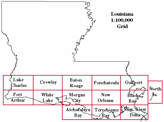
This CD-ROM contains Digital Orthophoto Quarter Quadrangles (DOQQs) in Multi-resolution Seamless Image Database (MrSID) format (.sid), index map layers in ESRI shapefile format (.shp), an ESRI ArcView project (.apr) with the index map layers referenced and this readme.txt file. The original DOQQs were produced for the state of Louisiana by 3001, Inc. through an innovative partnership with the United States Geological Survey (USGS). The entire data set is stored on multiple CD-ROMs. The geographic limit of the project is the state of Louisiana, south of 30.5 degrees latitude. Each CD contains MrSID images for specific 100K blocks in Louisiana. In certain cases, only a few images are contained in a 100K block due to the irregular geometric shape of the state, and therefore some 100K blocks will be combined into one CD to make efficient use of the CD-ROM storage media. A final CD will be made available containing DOQQs from 100K blocks in MrSID format that are currently not available.
Viewing the MrSID files requires ArcView 3.1 or later, with the MrSID extension, or the MrSID Viewer available from LizardTech's website at <URL:http://www.lizardtech.com>.
When using the contained ArcView project, the MrSID extension must be turned on in order to view the images.
The naming convention for the files contained on this CD-ROM can best be understood by the following example:
File Name: c3009334_nes_50.sid
c =color infrared
30093 = represents the 100k block in which the image resides
34 = The quadrangle in which the image resides
nes = represents the section the image comprises (Northeast section)
50 = MrSID compression ratio (50:1)
The directory structure of this CD is as follows:
\mrsid_[blockname].apr - ESRI ArcView project
\[blockname]_images\ - folder containing MrSID images
\shapes\ - folder containing ESRI shapefiles for use in the ArcView project
\readme.txt - this file